Verdalselva
| Verdalselva | |
|---|---|
 | |
 Location of the river  Verdalselva (Norway) | |
| Country | Norway |
| County | Trøndelag |
| Municipality | Verdal |
| Physical characteristics | |
| Main source |
Confluence of Helgåa and Inna Vuku, Verdal, Norway 41 metres (135 ft) 63°46′34″N 11°44′21″E / 63.77611°N 11.73917°E |
| River mouth |
Trondheimsfjord Verdalsøra, Verdal, Norway 0 metres (0 ft) 63°47′35″N 11°28′54″E / 63.79306°N 11.48167°ECoordinates: 63°47′35″N 11°28′54″E / 63.79306°N 11.48167°E |
| Length | 21 km (13 mi) |
| Basin features | |
| Basin size | 1,454 km2 (561 sq mi) |
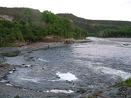
Verdalselva (English: Verdal River) is a 21-kilometre (13 mi) long river in the municipality of Verdal in Trøndelag county, Norway. The river begins at Holmen in the village of Vuku at the confluence of the rivers Inna and Helgåa. The river Inna drains the lake Innsvatnet near the Swedish border and the river Helgåa runs from the lake Veresvatnet at the village of Vera. The river Verdalselva flows west into the Trondheimsfjord, after passing through the town of Verdalsøra. The river Verdalselva is one of the country's best for salmon fishing.[1][2]
See also
References
- ↑ Ramfjord, Ole Johan (12 November 2009). "Vurderer å stenge populær lakseelv". Norwegian Broadcasting Corporation (in Norwegian).
- ↑ Store norske leksikon. "Verdalselva" (in Norwegian). Retrieved 2011-07-03.
This article is issued from
Wikipedia.
The text is licensed under Creative Commons - Attribution - Sharealike.
Additional terms may apply for the media files.