Ventura River
| Ventura River | |
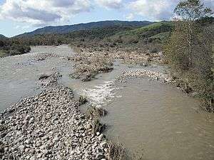
 Ventura River flowing through cobble near Meiners Oaks. | |
| Country | United States |
|---|---|
| State | California |
| Tributaries | |
| - left | San Antonio Creek, Cañada Larga Creek |
| - right | Matilija Creek, North Fork Matilija Creek, Coyote Creek |
| Source | Transverse Ranges |
| - location | Confluence of Matilija Creek and North Fork Matilija Creek, near Ojai |
| - elevation | 6,010 ft (1,832 m) |
| - coordinates | 34°29′07″N 119°18′02″W / 34.48528°N 119.30056°W [1] |
| Mouth | Pacific Ocean |
| - location | Ventura River Estuary, near Ventura |
| - elevation | 0 ft (0 m) |
| - coordinates | 34°16′32″N 119°18′28″W / 34.27556°N 119.30778°WCoordinates: 34°16′32″N 119°18′28″W / 34.27556°N 119.30778°W [1] |
| Length | 16.2 mi (26 km) |
| Basin | 226 sq mi (585 km2) [2] |
| Discharge | for near Ventura |
| - average | 72.6 cu ft/s (2 m3/s) [3] |
| - max | 63,600 cu ft/s (1,801 m3/s) |
| - min | 0 cu ft/s (0 m3/s) |
The Ventura River, located in western Ventura County in southern California, United States, flows 16.2 miles (26.1 km) from its headwaters through to the Pacific Ocean. The smallest of the three major rivers in Ventura County, the Ventura River's source stream is Matilija Creek, from its confluence with North Fork Matilija Creek. Matilija Creek is Ventura River's highest volume tributary, followed by San Antonio Creek, which joins the Ventura River from the east halfway to the ocean; Coyote Creek enters the river from the west about 7 miles (11 km) from the river mouth and Cañada Larga Creek from the east a few miles downstream. Much of the Ventura River's route is contained by the steeply sloped sides of the narrow Ventura Valley,[4] with its final 0.7 miles (1.1 km) through the broader Ventura River estuary, which extends from where it crosses under a 101 Freeway bridge through to the Pacific Ocean.[2]
Watershed
The Ventura River watershed encompasses 226 square miles (590 km2) consisting of steep mountains and foothills, with altitudes ranging from 6,010 feet (1,830 m) to sea level. Valley floors are home to communities and farms. Conditions in much of the watershed remain natural and undeveloped, with 57% of its land area in protected status. Most of the watershed's primary streams and drainages are unchannelized, though the natural hydrologic patterns have been modified by two dams (the Casitas and Matilija) and three levees (the Ventura River, Casitas Springs, and Live Oak).[2]
Developed land (excluding grazing) comprises only about 13% of the total land area in the watershed. The northern half of the watershed lies within Los Padres National Forest. The watershed's southern half has agriculture as the dominant land use, with irrigated citrus and avocados as the primary crops while a significant area of land is used for cattle grazing.[2] The populated area includes two cities and a number of unincorporated communities. The smaller of the two cities, Ojai, lies entirely within the watershed, 13-mile inland (21 km) at an elevation of 746 feet (227 m). Only 13% of the larger city of Ventura lies within the watershed, adjacent to the coast on the lower stretch of the Ventura River.
The population of the watershed is relatively small and the rate of growth low. The population is approximately 44,140, which represents just 5.4% of Ventura County's population (as of 2010 Census). The population is 58% white, 37% Hispanic or Latino, 2% Asian, and 3% other races. Income varies widely, and several areas qualify as disadvantaged or severely disadvantaged communities.[2]
Climate


Rainfall varies geographically, seasonally, and from year to year. Median annual precipitation is 14.12 inches or 359 millimetres in the lower watershed, 19.20 inches or 488 millimetres in the middle watershed, and 28.74 inches or 730 millimetres in the upper watershed. However, even in the subhumid upper basin, rainfall is infrequent – falling on as few days in a year as in hot, arid Phoenix, Arizona – but when rain does fall it can be extremely heavy with totals of 20 inches or 510 millimetres in a week not uncommon in the middle and upper basins. Consequently, cycles of drought and flood are the norm: as an illustration, in the main settlement of Ojai since 1906, 67 percent of the years have had less than the mean rainfall.
Many parts of the Ventura River stream network are typically dry during much of the year. Surface water readily disappears underground in some stream reaches (segments); in others, groundwater regularly feeds streamflow.[2]
Flooding
Rainfall in the Matilija Wilderness, the river's headwaters, is the highest in Ventura County, with average annual rainfall that is over twice that of rainfall at the coast. The steep terrain of the Ventura River watershed, coupled with intense downpours that can occur in its upper portions, result in flash flood conditions where floodwaters rise and fall in a matter of hours. Major or moderate floods have occurred once every five years on average since 1933.[2][5]
The most damaging riverine flood recorded in the Ventura River watershed occurred in 1969.[6] The watershed above Ojai received a staggering 43 inches of rain in nine days in January. The floodwaters and associated debris rolled down out of the mountains, flooding homes in Casitas Springs and Live Oak Acres. Much agricultural land, primarily citrus groves, was seriously damaged or destroyed. All over Ventura County, transportation facilities, including roads, bridges, and railroad tracks, were damaged. The wastewater treatment plant below Foster Park was severely damaged and dumped raw sewage into the Ventura River. In addition, sewer trunk lines were broken along the Ventura River and San Antonio Creek. Untreated sewage polluted the river and beach. The capacity of the Matilija reservoir was significantly reduced by siltation from the flood.[2]
Water Quality
Limited land development and large areas of protected habitat in the Ventura River watershed help support surface water that is relatively clean compared with more developed areas in the region. However, all of the watershed's major waterbodies are on the Clean Water Act Section 303(d) list of impaired waterbodies. Surface waters are impaired for a number of factors, including trash, algae, water diversion/pumping, eutrophic conditions, low dissolved oxygen, nitrogen, fish barriers, coliform, bacteria, mercury, and total dissolved solids.[2]
Water Supply
Unlike almost all of its neighbors in southern California, Ventura River watershed is 100% dependent on local water supplies. Lake Casitas serves as the major surface water supply reservoir in the watershed and groundwater is heavily relied upon. On average, surface water comprises about 55% of the water recovered from the watershed and groundwater comprises about 45%.[2]
Cycles of drought and flooding occur regularly. Annual rainfall in downtown Ojai has ranged from a low of seven inches to a high of 49 inches—a sevenfold variation. Because the annual amount of rainfall received is highly variable, water supplies must be managed with caution.[2]
Two small coastal watersheds—the North Ventura Coastal Streams watershed and the Buenaventura watershed—flank the Ventura River watershed's lower section and are dependent on its water. Water from the Ventura River watershed is used to irrigate avocado orchards in the North Ventura Coastal Streams watershed and serves a significant population in a portion of the Buenaventura watershed that lies within the City of Ventura.[2]
Dams
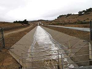
The flow of the Ventura River and its tributary Coyote Creek have been reduced by the completion of Casitas Dam, which forms Casitas Reservoir. The dam is on Coyote Creek about 2 miles upstream of the junction with the Ventura River. The Robles Diversion Dam was constructed on the Ventura River in 1958 to divert up to 107,800 acre-feet of water per year through a four-and-a-half mile canal to Casitas Reservoir.[7] About 40% of the total water in Lake Casitas is supplied from high winter flows in the Ventura River. Casitas Municipal Water District sells water to both domestic and agricultural customers.
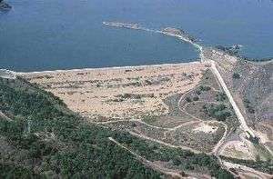
The Matilija Creek, source stream and main tributary of the Ventura River, is controlled by the Matilija Dam. Completed in 1948, it was built to store 7,000 acre feet (8,600,000 m3) of water, but sediment has reduced its capacity by 90%. The Matilija Dam was built by Ventura County, against the advice of the United States Army Corps of Engineers, who pointed out that the characteristics of waterways in the region would lead to sediment buildup, rendering the dam ineffective and dangerous.[8]
Ecology
The watershed's rugged topography, largely undeveloped status, and Mediterranean climate combine to make for an area of exceptional biodiversity. It supports a diverse array of natural habitats, including grassland, coastal sage scrub, chaparral, oak woodlands and savannas; coniferous woodlands; riparian scrub, woodlands and wetlands; alluvial scrub; freshwater aquatic habitats; estuarine wetlands; and coastal cobble, dune and intertidal habitats. The Ventura River estuary, at the mouth of the Ventura River, is an exceptionally valuable wetland habitat and ecological resource in the watershed.[2]
The watershed is home to numerous protected species and habitats, including 137 plants and animals protected at either the federal, state, or local level. The federally endangered southern California steelhead (listed in 1997) is of particular importance, given the watershed's often dry and always variable climate.[2] The steelhead found in the Ventura River are part of the Southern California Steelhead Distinct Population Segment (DPS) were listed as federally endangered.[9] Genetic analysis of the steelhead trout (Oncorhynchus mykiss) in the Ventura river watershed (both above and below Matilija Dam) has shown them to be of native and not hatchery stocks.[10][11]
The Ventura River Preserve, owned by the Ojai Valley Land Conservancy (OVLC), protects 1,600 acres (650 ha) of land in and adjacent to the Ventura River, including 3 miles (4.8 km) of the river. Additional land in and adjacent to the river is protected by OVLC, along with Ventura Hillsides Conservancy, Ventura County Watershed Protection District, Ventura County Parks, and the City of Ventura.[2][12]
Restoration
Plans and projects have been underway since the 1990s to restore natural features, flora and fauna to the river. The watershed is challenged by invasive, non-native plants, such as giant reeds, ice plants and castor bean, which choke out the willows and estuary-area salt marsh which normally support the native fauna.[2][13]
A USA Petrochem petroleum refinery, which is situated within the 100-year floodplain of the Ventura River, was shutdown in 1985. In August 2012 the Environmental Protection Agency (EPA) determined there had been discharge to navigable waters of the United States in violation of the Clean Water Act. The EPA's site assessment found that there were numerous leaking pipelines, leaking tanks and leaking production vessels throughout the abandoned property. The site was also out of compliance with Los Angeles Water Quality Control Board's Ventura River Estuary Trash Total Maximum Daily Load. The EPA issued an order that the site must be cleaned up or daily fines would be sought from the owner.[14] In 2015, the site owner agreed to remove all machinery and equipment, which would complete the cleanup of the plant.[15]
Further upriver, there is a major project underway to remove the Matilija Dam, in part to return access to the steelhead to spawning habitat while also enhancing the overall watershed. Since 1998, efforts to remove the dam have received regulatory approvals but little funding, with one ceremonial section last removed in 2001.[8]
Recreation
The Ventura River Parkway Trail was built on an abandoned railroad spur (CA_VEN-1109H) that was constructed by the Ventura and Ojai Valley Railroad in 1898 and acquired by Southern Pacific in 1899.[16] The rail trail, that runs along the easterly bank of the river, was designated a National Recreation Trail in 2014.[17] The "Ventura River Trail" part of the trail (completed in 1999) extends from the coast to Foster Park, and the "Ojai Valley Trail" part (completed in 1987) extends from Foster Park into the City of Ojai. The 15.8-mile trail (25.4 km), with the steady grade of the former Southern Pacific Railway right-of-way, is very popular with bicyclists, as well as walkers and horseback riders (on the Ojai Valley Trail segment). As of 2015, the vision of a "Ventura River Parkway," a network of trails, vista points, and natural areas along the river, is being actively pursued by a coalition of stakeholders.[2][18][19]
State Route 33 also roughly parallels the river through the Ventura River Valley. A portion of SR 33, north of the SR 150, is officially designated as a state scenic highway, and the entire Ventura River Valley section is eligible for the designation.[20]
The watershed is a recreation destination for hikers, walkers, bikers, surfers, campers, fishermen, boaters, backpackers, equestrians, and birders, as well as artists, spiritual seekers, and students of natural history. Many local organizations are committed to providing the public with access to nature and nature-based recreation opportunities. Camping in the Ventura River bottom, which is dry most of the year, was outlawed by the Ventura City Council in 1995 after floods killed one man and prompted the evacuation of 12 other people near the Main Street bridge.[13]
Collaborative Watershed Planning

The Ventura River Watershed Council, which includes government agencies, nonprofit groups, businesses, community groups, and individuals, prepared a watershed management plan. Approved in 2015, this comprehensive plan proposed ways to improve the health and sustainability of the watershed.[21]
See also
References
- 1 2 "Ventura River". Geographic Names Information System. United States Geological Survey. 1981-01-19. Retrieved 2014-01-19.
- 1 2 3 4 5 6 7 8 9 10 11 12 13 14 15 16 17 "The Ventura River Watershed Management Plan". Ventura River Watershed Council. Retrieved 2015-06-15.
- ↑ "USGS Gage #11118501 Ventura River and Ventura City Diversion near Ventura, CA" (PDF). National Water Information System. U.S. Geological Survey. 1933–2007. Retrieved 2014-01-19.
- ↑ Rincon Consultants, Inc. (June 2014 "Olivas Park Drive Extension Project Final Environmental Impact Report SCH # 1995081004" Archived 2014-07-13 at the Wayback Machine. City of Ventura
- ↑ Miller, Joanna M. (March 1, 1992). "No Concrete Answers to Ventura Flooding : Environment: Unlike the L.A. River, lining the waterway is not an option. Experts say only fail-safe method is to forbid building in flood plains". Los Angeles Times. Retrieved 19 March 2017.
- ↑ Miller, Joanna M. (March 20, 1994). "A Few Deadly Floods Stand Out in County". Los Angeles Times. Retrieved 19 March 2017.
- ↑ "Robles Dam". U.S. Department of Interior Bureau of Reclamation. 2009-06-04. Retrieved 2013-03-16.
- 1 2 Booth, William (2001-01-21). "Dam-removal Sentiment Flows More Freely Now". Orlando Sentinel. Retrieved 2017-10-05.
- ↑ NOAA/NMFS (1997-08-18). "Endangered and Threatened Species: Listing of Several Evolutionary Significant Units (ESUs) of West Coast Steelhead" (PDF). Federal Register. Retrieved 2013-03-16.
- ↑ Anthony J. Clemento, Eric C. Anderson, David Boughton, Derek Girman, John Carlos Garza (2009). "Population genetic structure and ancestry of Oncorhynchus mykiss populations above and below dams in south-central California" (PDF). Conservation Genetics: 1321–1336. doi:10.1007/s10592-008-9712-0. Retrieved 2011-06-11.
- ↑ "Steelhead/Rainbow Trout (Oncorhynchus mykiss) Resources South of the Golden Gate, California: Distribution Report:Ventura County (376 KB PDF)". Center for Ecosystem Management and Restoration. Retrieved October 12, 2015.
- ↑ Martinez, Arlene (October 1, 2016). "Hut in Ventura River must go, officials say". Ventura County Star. Retrieved 2 October 2016.
- 1 2 McDonald, Jeff (July 09, 1995) "Ventura River Area Gets a 2nd Chance : Environment: Ambitious $754,000 cleanup plan calls for clearing site of harmful invasive vegetation, renewing trails and diverting flood-control channels." Los Angeles Times
- ↑ Sullivan, Michael (02/14/2013) "EPA orders cleanup at USA Petrochem site" Ventura County Reporter
- ↑ Wilson, Kathleen (January 29, 2015) "Long-closed refinery expected to be cleaned up by year end" Ventura County Star
- ↑ MacGregor, Hilary E. (September 18, 1996). "In Search of the Missing Link". Los Angeles Times.
- ↑ Kallas, Anne (June 7, 2014) "On the path to restoring the river: Trail in county gets designation from government" Ventura County Star (subscription may be required for this article.
- ↑ Lubin, Theresa, Ventura County Parks (July 29, 2015)
- ↑ Martinez, Arlene (July 27, 2016). "Plans for Ventura River Parkway, a route of trails from Ventura to Ojai, move along". Ventura County Star. Retrieved 28 July 2016.
- ↑ CA Codes (shc:263.3)
- ↑ staff (March 19, 2015) "Group releases Ventura River watershed management plan" Ventura County Star
External links
- Friends of the River
- Ojai Valley Land Conservancy
- Santa Barbara Channelkeeper
- Ventura River Streamwalk Program at the Wayback Machine (archived September 28, 2011)
- Stream Team: Ventura River
- United States Bureau of Reclamation - Ventura River Project