Veľký Slavkov
| Veľký Slavkov | ||
| Municipality | ||
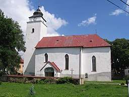 Church of Saint Andrew, the Apostle | ||
|
||
| Country | Slovakia | |
|---|---|---|
| Region | Prešov | |
| District | Poprad | |
| Elevation | 677 m (2,221 ft) | |
| Coordinates | 49°06′N 20°17′E / 49.100°N 20.283°ECoordinates: 49°06′N 20°17′E / 49.100°N 20.283°E | |
| Area | 12.35 km2 (4.77 sq mi) | |
| Population | 1,237 (2010-12-31) | |
| Density | 100/km2 (259/sq mi) | |
| First mentioned | 1251 | |
| Postal code | 059 91 | |
| Car plate | PP | |
 Location of Veľký Slavkov in Slovakia | ||
| Statistics: | ||
| Website: www.velkyslavkov.sk | ||

Veľký Slavkov (Hungarian: Nagyszalók, German: Groß Schlagendorf, Polish: Wielki Sławków) is a village and municipality in Poprad District in the Prešov Region of northern Slovakia.[1]
Geography
The municipality lies at an elevation of 677 metres (2,221 ft) and covers an area of 12.347 km² (4.767 mi²). It has a population of about 1,150.
History
In historical records the village was first mentioned in 1251.
Economy and infrastructure
Its proximity to High Tatras have developed the village as a tourist destination. In Velký Slavkov are several pensions and a hotel.
References
- ↑ "Statistical Office of the Slovak Republic" (PDF). Výsledky SODB 2011. Štatistický úrad SR. Archived from the original (PDF) on October 12, 2013. Retrieved 9 August 2012.
Municipalities of Poprad District | ||
|---|---|---|
This article is issued from
Wikipedia.
The text is licensed under Creative Commons - Attribution - Sharealike.
Additional terms may apply for the media files.