Štrba
| Štrba | ||
| Municipality | ||
 Štrba | ||
|
||
| Country | Slovakia | |
|---|---|---|
| Region | Prešov | |
| District | Poprad | |
| Elevation | 850 m (2,789 ft) | |
| Coordinates | 49°04′N 20°04′E / 49.067°N 20.067°ECoordinates: 49°04′N 20°04′E / 49.067°N 20.067°E | |
| Area | 43.463 km2 (16.78 sq mi) | |
| Population | 3,640 (2010-12-31) | |
| Density | 84/km2 (218/sq mi) | |
| First mentioned | 1281 | |
| Postal code | 059 38 | |
| Area code | +421-52 | |
| Car plate | PP | |
  Location of Štrba in Slovakia | ||
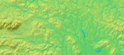  Location of Štrba in the Prešov Region | ||
| Statistics: MOŠ/MIS | ||
| Website: www.strba.sk | ||
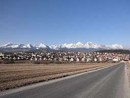
Štrba is a village in the Poprad District, Prešov Region, northern Slovakia.[1] It is situated in the Sub-Tatra Basin, which separates the High Tatras and Low Tatras at the European continental divide between the Baltic and the Black Sea. It is approximately 16 km (10 mi.) west of the city of Poprad.
History
Historical records first mention Štrba in 1280. It had been also known under the names Tschirm, Sorba and Csorba. The village owns the lands around the mountain glacial lake, and now resort, of Štrbské pleso, to which it gave its name. Locals had started to profit from the construction of High Tatras facilities at the end of 19th century.
Geography
The municipality lies at an altitude of 829 metres and covers an area of 43.463 km². It has a population of 3,653 people. Its detached borough of Tatranská Štrba hosts the Štrba railway station, the valley terminus of the Štrbské Pleso - Štrba rack railway, and a stop on one of Slovakia's major railways. The mountain resort settlement of Štrbské Pleso also belongs to the village.[2]
References
- ↑ "Statistical Office of the Slovak Republic" (PDF). Výsledky SODB 2011. Štatistický úrad SR. Retrieved 2012-09-08.
- ↑ Štrbské Pleso patrí mestu Štrba (Štrbské Pleso belongs to the town of Štrba) - newspaper Pravda, 3 May 2007 (in Slovak)
External links
Municipalities of Poprad District | ||
|---|---|---|