Vandiver, Alabama
| Vandiver, Alabama | |
|---|---|
| Census-designated place & Unincorporated community | |
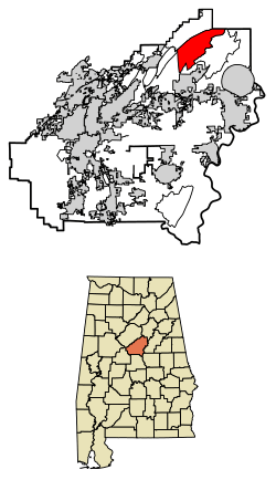 Location of Vandiver in Shelby County, Alabama. | |
 Vandiver, Alabama Location of Vandiver in Shelby County, Alabama.  Vandiver, Alabama Vandiver, Alabama (the US) | |
| Coordinates: 33°28′14″N 86°30′48″W / 33.4706617°N 86.5133163°WCoordinates: 33°28′14″N 86°30′48″W / 33.4706617°N 86.5133163°W | |
| Country | United States |
| State | Alabama |
| County | Shelby |
| Area[1] | |
| • Total | 21.01 sq mi (54.41 km2) |
| • Land | 20.47 sq mi (53.01 km2) |
| • Water | 0.54 sq mi (1.41 km2) |
| Elevation | 531 ft (162 m) |
| Population (2010)[2] | |
| • Total | 1,529 |
| • Estimate (2016)[3] | N/A |
| Time zone | UTC-6 (Central (CST)) |
| • Summer (DST) | UTC-5 (CDT) |
| Area code(s) | 205 |
| GNIS feature ID | 128408[4] |
Vandiver is a census-designated place (CDP) and unincorporated community in Shelby County, Alabama, United States. Its population was 1168 as of the 2010 census.[2] One structure in Vandiver, the Falkner School, is listed on the Alabama Register of Landmarks and Heritage.[5]
Demographics
| Historical population | |||
|---|---|---|---|
| Census | Pop. | %± | |
| U.S. Decennial Census[6] | |||
Notable people
- Wes Helms, former Major League Baseball player
- David McCluskey, professional boxer who fought future world champions Mike McCallum, Roy Jones Jr., Bernard Hopkins, Julio Cesar Vasquez, and Glen Johnson.[7]
References
- ↑ "2016 U.S. Gazetteer Files". United States Census Bureau. Retrieved Jul 17, 2017.
- 1 2 "American FactFinder". United States Census Bureau. Retrieved 2011-05-14.
- ↑ "Population and Housing Unit Estimates". Retrieved June 9, 2017.
- ↑ "Vandiver". Geographic Names Information System. United States Geological Survey.
- ↑ "Properties on the Alabama Register of Landmarks & Heritage". Alabama Historical Commission. www.preserveala.org. Archived from the original on September 4, 2012. Retrieved June 5, 2014.
- ↑ "Census of Population and Housing". Census.gov. Retrieved June 4, 2016.
- ↑ "David McCluskey - Boxer". Boxrec.com. 1962-08-04. Retrieved 2014-06-05.
Municipalities and communities of Shelby County, Alabama, United States | ||
|---|---|---|
| Cities | 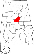 | |
| Towns | ||
| CDPs | ||
| Unincorporated communities | ||
| Footnotes | ‡This populated place also has portions in an adjacent county or counties | |
This article is issued from
Wikipedia.
The text is licensed under Creative Commons - Attribution - Sharealike.
Additional terms may apply for the media files.