Van Buren Township, Hancock County, Ohio
| Van Buren Township, Hancock County, Ohio | |
|---|---|
| Township | |
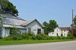 On the Lincoln Highway in New Stark | |
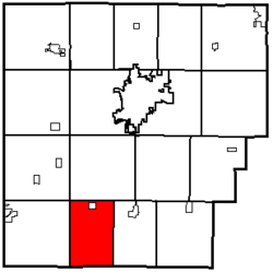 Location of Van Buren Township in Hancock County | |
| Coordinates: 40°52′39″N 83°43′20″W / 40.87750°N 83.72222°WCoordinates: 40°52′39″N 83°43′20″W / 40.87750°N 83.72222°W | |
| Country | United States |
| State | Ohio |
| County | Hancock |
| Area | |
| • Total | 24.4 sq mi (63.2 km2) |
| • Land | 24.4 sq mi (63.2 km2) |
| • Water | 0.0 sq mi (0.0 km2) |
| Elevation[1] | 889 ft (271 m) |
| Population (2010) | |
| • Total | 915 |
| • Density | 38/sq mi (14.5/km2) |
| Time zone | UTC-5 (Eastern (EST)) |
| • Summer (DST) | UTC-4 (EDT) |
| ZIP code | 45889 |
| Area code(s) | 419 |
| FIPS code | 39-79408[2] |
| GNIS feature ID | 1086254[1] |
Van Buren Township is one of the seventeen townships of Hancock County, Ohio, United States. As of the 2010 census, the population was 915,[3] of whom 694 lived in the unincorporated portions of the township.
Geography
Located in the southern part of the county, it borders the following townships:
- Eagle Township - north
- Madison Township - east
- Washington Township, Hardin County - south
- Liberty Township, Hardin County - southwest corner
- Orange Township - west
- Union Township - northwest corner
The village of Jenera is located in northern Van Buren Township.
Name and history
Statewide, other Van Buren Townships are located in Darke, Putnam, and Shelby counties.
Van Buren Township was organized in 1831. It was named for Martin Van Buren, who had at that time served as Secretary of State, and who would go on to become President of the United States.[4]
Government
The township is governed by a three-member board of trustees, who are elected in November of odd-numbered years to a four-year term beginning on the following January 1. Two are elected in the year after the presidential election and one is elected in the year before it. There is also an elected township fiscal officer,[5] who serves a four-year term beginning on April 1 of the year after the election, which is held in November of the year before the presidential election. Vacancies in the fiscal officership or on the board of trustees are filled by the remaining trustees.
References
- 1 2 "US Board on Geographic Names". United States Geological Survey. 2007-10-25. Retrieved 2008-01-31.
- ↑ "American FactFinder". United States Census Bureau. Retrieved 2008-01-31.
- ↑ "Geographic Identifiers: 2010 Census Summary File 1 (G001): Van Buren township, Hancock County, Ohio". American Factfinder. U.S. Census Bureau. Retrieved December 27, 2017.
- ↑ History of Hancock County, Ohio. Warner, Beers. 1886. p. 498.
- ↑ §503.24, §505.01, and §507.01 of the Ohio Revised Code. Accessed 4/30/2009.
External links
Municipalities and communities of Hancock County, Ohio, United States | ||
|---|---|---|
| Cities | 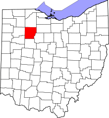 | |
| Villages | ||
| Townships | ||
| Unincorporated communities | ||
| Footnotes | ‡This populated place also has portions in an adjacent county or counties | |