Valdemarín
| Valdemarín | |
|---|---|
| Ward of Madrid | |
 Moncloa-Aravaca district within Madrid. Valdemarín is in the north-western borders | |
| Country |
|
| Aut. community |
|
| Municipality |
|
| District |
|
| Population | 4,000 |
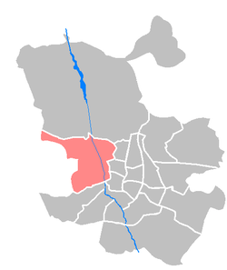
Valdemarín is a ward (barrio) of Madrid belonging to the district of Moncloa-Aravaca.[1] Its code number is 95 and, as of 2006, its population was of 4,000.
Geography
The ward is located in north-western area of the city, crossed by the M-40 orbital motorway and close to the borders of Moncloa-Aravaca with Fuencarral-El Pardo. Nearest barrios are Aravaca, in the south, and Ciudad Universitaria, in the east.[2] Just in the north of Valdemarín, over the M-40, is situated a great city forest (16,000 ha) named Monte de El Pardo.[3]
The principal road of the ward is Avenida de Valdemarín, running from east to west.[2]
References
- ↑ (in Spanish) Infos and list of wards of Moncloa-Aravaca (Madrid official website)
- 1 2 Valdemarín on Google Maps
- ↑ (in Spanish) Infos about Monte de El Pardo
External links
- (in Spanish) Valdemarín at WikiMadrid
Coordinates: 40°28′21.22″N 3°46′48.86″W / 40.4725611°N 3.7802389°W
This article is issued from
Wikipedia.
The text is licensed under Creative Commons - Attribution - Sharealike.
Additional terms may apply for the media files.