Latina (Madrid)
| Latina | |
|---|---|
| District of Madrid | |
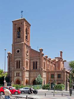 Church of Santa Cristina | |
 | |
| Country |
|
| Aut. community |
|
| Municipality |
|
| Government | |
| • Concejal | Nieves Sáez de Adana |
| Area | |
| • Total | 25.41 km2 (9.81 sq mi) |
| Population | 256,644 |
| • Density | 10,097.8/km2 (26,153/sq mi) |
| Madrid district number | 10 |
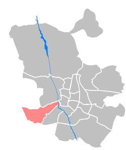
Latina is one of the districts of Madrid. Different from La Latina area in the district of Centro, its name comes from Beatriz Galindo La Latina.
Geography
Position
The district, situated in a southwestern suburb of Madrid, borders with the following districts: Carabanchel, Arganzuela, Centro and Moncloa-Aravaca. It includes the old cross-roads of the road of Extremadura, and it has several tributary streams to Manzanares river (Luche, Caño Roto etc.).
Subdivision
The district is administratively divided into 7 wards (Barrios):
History
The district is found over Quaternary terrains. There are several promontories in the ground: Bermejo, Cerro de la Piedra, Cerro de los Alemanes, Cerro de los Cuervos, Cerro de la Mica (the highest one) and Cerro Almodóvar.
The district was included in the 1845 administrative division of Madrid in 10 districts. It included all the so-called los Carabancheles districts which were added to the city of Madrid as the district of Carabanchel in 1948. In 1971 that district was divided in the three current districts: Usera, Carabanchel and Latina.
Government
_01.jpg)
The Civil Aviation Accident and Incident Investigation Commission has its headquarters in Latina.[1]
Transport
- Cercanías train line C-5. Stations: Aluche, Cuatro Vientos, Fanjul, Laguna and Las Águilas.
- Metro de Madrid: Lines 5 & 10.
Public services, interesting places
- Parque de Aluche or Parque Arias Navarro.
- Centro Comercial Aluche
- Junta Municipal de Distrito
- Colegio Público de Educación Especial Fray Pedro Ponce de León.
- Polideportivo municipal de Aluche.
References
- ↑ "Contáctenos Archived 2010-09-16 at the Wayback Machine.." Civil Aviation Accident and Incident Investigation Commission. Retrieved on September 17, 2010. "Comisión de Investigación de Accidentes e Incidentes de Aviación Civil: C\ Fruela, 6 28011 Madrid" Direct map link Archived 2011-07-20 at the Wayback Machine. Direct link to image of headquarters
External links
![]()
- Information on Latina at www.munimadrid.es (in Spanish)
- Maps and satellite images at www.munimadrid.es (PDF document) (in Spanish)
Coordinates: 40°24′41″N 3°42′30″W / 40.411360°N 3.708417°W