Valcourt Airport
| Valcourt Airport | |||||||||||
|---|---|---|---|---|---|---|---|---|---|---|---|
 | |||||||||||
| Summary | |||||||||||
| Airport type | Public | ||||||||||
| Operator | Aero Club de Valcourt | ||||||||||
| Location | Valcourt, Quebec | ||||||||||
| Time zone | EST (UTC−05:00) | ||||||||||
| • Summer (DST) | EDT (UTC−04:00) | ||||||||||
| Elevation AMSL | 740 ft / 226 m | ||||||||||
| Coordinates | 45°28′52″N 072°18′37″W / 45.48111°N 72.31028°WCoordinates: 45°28′52″N 072°18′37″W / 45.48111°N 72.31028°W | ||||||||||
| Map | |||||||||||
 CSQ2 Location in Quebec | |||||||||||
| Runways | |||||||||||
| |||||||||||
|
Sources: Canada Flight Supplement[1] | |||||||||||
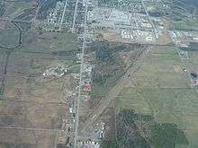
Valcourt Airport, (TC LID: CSQ3), is located 1 nautical mile (1.9 km; 1.2 mi) south of Valcourt, Quebec, Canada. The runway was built on the right-of-way of an old Canadian Pacific Railway branch line that once ran between the towns of Eastman and Windsor Mills, Quebec.[2] In 2005, the 3,750 ft (1,143 m) runway was repaved, with the centre 20 ft (6.1 m) being asphalt, with gravel on each side.
References
- ↑ Canada Flight Supplement. Effective 0901Z 19 July 2018 to 0901Z 13 September 2018.
- ↑ Titre : 31-H-08, Orford
| By name | |
|---|---|
| By location indicator | |
| By province/territory | |
| By area | |
| National Airports System | |
| Related | |
| |
This article is issued from
Wikipedia.
The text is licensed under Creative Commons - Attribution - Sharealike.
Additional terms may apply for the media files.