North Utica, Illinois
| North Utica, Illinois | |
|---|---|
| Village | |
| North Utica | |
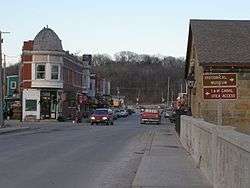 Looking north through Utica | |
| Motto(s): "Historical Past Promising Future" | |
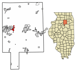 Location of North Utica in LaSalle County, Illinois. | |
.svg.png) Location of Illinois in the United States | |
| Coordinates: 41°20′32″N 89°0′51″W / 41.34222°N 89.01417°WCoordinates: 41°20′32″N 89°0′51″W / 41.34222°N 89.01417°W | |
| Country | United States |
| State | Illinois |
| County | LaSalle |
| Township | Utica |
| Area[1] | |
| • Total | 3.47 sq mi (8.98 km2) |
| • Land | 3.46 sq mi (8.95 km2) |
| • Water | 0.01 sq mi (0.03 km2) |
| Elevation | 476 ft (145 m) |
| Population (2010) | |
| • Total | 1,352 |
| • Estimate (2016)[2] | 1,339 |
| • Density | 387.55/sq mi (149.63/km2) |
| Time zone | UTC-6 (CST) |
| • Summer (DST) | UTC-5 (CDT) |
| ZIP Code(s) | 61373 |
| Area code(s) | 815 and 779 |
| FIPS code | 17-54222 |
| Wikimedia Commons | North Utica, Illinois |
| Website | www.utica-il.gov |
| [3] | |
North Utica, often known as Utica, is a village in Utica Township, LaSalle County, Illinois. The population was 1352 at the 2010 United States Census. It is part of the Ottawa–Streator Micropolitan Statistical Area.
While North Utica is the proper name for the city, advertising on nearby Interstates 80 and 39 refers to the village by its original name, Utica. In addition, people who live in the area, official Interstate signage, and signs indicating the city limits all refer to the town as Utica.
History
The town of Utica had previously been established on the banks of the Illinois River during the 1830s, but flooding and the construction of the Illinois and Michigan Canal a few miles north encouraged redevelopment of the village there as North Utica.
Utica Tornado of 2004
There were 9 fatalities during a F3 tornado on April 20, 2004, which heavily damaged the downtown business district.
Geography
North Utica is located at 41°20′32″N 89°0′51″W / 41.34222°N 89.01417°W (41.3422775, -89.0142070).[3]
According to the 2010 census, North Utica has a total area of 3.471 square miles (8.99 km2), of which 3.46 square miles (8.96 km2) (or 99.68%) is land and 0.011 square miles (0.03 km2) (or 0.32%) is water.[4]
Demographics
| Historical population | |||
|---|---|---|---|
| Census | Pop. | %± | |
| 1880 | 767 | — | |
| 1890 | 1,094 | 42.6% | |
| 1900 | 1,150 | 5.1% | |
| 1910 | 976 | −15.1% | |
| 1920 | 1,037 | 6.3% | |
| 1930 | 1,120 | 8.0% | |
| 1940 | 1,019 | −9.0% | |
| 1950 | 985 | −3.3% | |
| 1960 | 1,014 | 2.9% | |
| 1970 | 974 | −3.9% | |
| 1980 | 1,067 | 9.5% | |
| 1990 | 848 | −20.5% | |
| 2000 | 977 | 15.2% | |
| 2010 | 1,352 | 38.4% | |
| Est. 2016 | 1,339 | [2] | −1.0% |
| U.S. Decennial Census[5] | |||
As of the census[6] of 2010, there were 1352 people residing in the village. The population density was 389.6 people per square mile (249.8/km²). There were 598 housing units at an average density of 172.3 per square mile (114.6/km²). The racial makeup of the village was 98.52% White, 0.36% African American, 0.14% Native American, 0.14% Asian, 0.61% from other races, and 0.73% from two or more races. Hispanic.
There were 598 households out of which 26.2% had children under the age of 18 living with them. The average household size was 2.48 and the average family size was 2.93.
In the village, the population was spread out with 23.0% under the age of 18, 6.9% from 18 to 24, 9.5% from 25 to 34, 23.1% from 35 to 49, 44.1% from 50 to 64, and 15.5 who were 65 years of age or older, 47.5% Male, 52.5% Female
The median income for a household in the village was $43,182, and the median income for a family was $54,107. Males had a median income of $37,614 versus $20,074 for females. The per capita income for the village was $23,061. About 3.7% of families and 7.2% of the population were below the poverty line, including 13.1% of those under age 18 and 4.7% of those age 65 or over.
Culture
Local attractions include Grizzly Jack's Grand Bear Resort and Starved Rock State Park.
Utica is the location of the annual Burgoo Festival on Columbus Day weekend in October. The Burgoo Festival is a fundraising event hosted by the LaSalle County Historical Society.
Notable people
- Leo Cahill, pro football coach and executive
References
- ↑ "2016 U.S. Gazetteer Files". United States Census Bureau. Retrieved Jun 30, 2017.
- 1 2 "Population and Housing Unit Estimates". Retrieved June 9, 2017.
- 1 2 U.S. Geological Survey Geographic Names Information System: Village of North Utica, Illinois
- ↑ "G001 - Geographic Identifiers - 2010 Census Summary File 1". United States Census Bureau. Retrieved 2015-12-25.
- ↑ "Census of Population and Housing". Census.gov. Retrieved June 4, 2015.
- ↑ "American FactFinder". United States Census Bureau. Retrieved 2008-01-31.
External links
Municipalities and communities of LaSalle County, Illinois, United States | ||
|---|---|---|
| Cities | ||
| Villages | ||
| Townships |
| |
| CDPs | ||
| Other unincorporated communities |
| |
| Ghost towns |
| |
| Footnotes | ‡This populated place also has portions in an adjacent county or counties | |