Ust-Koksinsky District
| Ust-Koksinsky District Усть-Коксинский район (Russian) Кӧк-Суу аймак (Altay) | |
|---|---|
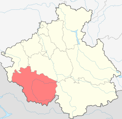 Location of Ust-Koksinsky District in the Altai Republic | |
| Coordinates: 51°57′N 85°57′E / 51.950°N 85.950°ECoordinates: 51°57′N 85°57′E / 51.950°N 85.950°E | |
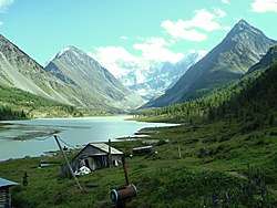 Lake Akkemskoye, a protected area of Russia in Ust-Koksinsky District | |
 | |
|
| |
| Location | |
| Country | Russia |
| Federal subject | Altai Republic[1] |
| Administrative structure (as of October 2015) | |
| Administrative center | selo of Ust-Koksa[1] |
| Administrative divisions:[1] | |
| Rural settlements | 9 |
| Inhabited localities:[1] | |
| Rural localities | 42 |
| Municipal structure (as of March 2015) | |
| Municipally incorporated as | Ust-Koksinsky Municipal District[2] |
| Municipal divisions:[2] | |
| Urban settlements | 0 |
| Rural settlements | 9 |
| Statistics | |
| Area | 12,960 km2 (5,000 sq mi)[3] |
| Population (2010 Census) | 17,020 inhabitants[4] |
| • Urban | 0% |
| • Rural | 100% |
| Density | 1.31/km2 (3.4/sq mi)[5] |
| Time zone | KRAT (UTC+07:00)[6] |
| Established | October 19, 1923[7] |
| Previous names | Uymonsky District (until April 10, 1933)[7] |
| Official website | |
| Ust-Koksinsky District on WikiCommons | |
| 2010 Census | 17,020[4] |
|---|---|
| 2002 Census | 17,481[8] |
| 1989 Census | 16,734[9] |
| 1979 Census | 16,367[10] |
Ust-Koksinsky District (Russian: Усть-Ко́ксинский район; Altay: Кӧк-Суу аймак) is an administrative[1] and municipal[2] district (raion), one of the ten in the Altai Republic, Russia. It is located in the west and southwest of the republic. The area of the district is 12,960 square kilometers (5,000 sq mi).[3] Its administrative center is the rural locality (a selo) of Ust-Koksa.[1] As of the 2010 Census, the total population of the district was 17,020, with the population of Ust-Koksa accounting for 25.7% of that number.[4]
History
The district was established on October 19, 1923 as Uymonsky District (Уймонский район)[7] within Oirot Autonomous Oblast.[11] It was given its present name on April 10, 1933.[7]
Administrative and municipal status
Within the framework of administrative divisions, Ust-Koksinsky District is one of the ten in the Altai Republic.[1] As a municipal division, the district is incorporated as Ust-Koksinsky Municipal District.[2] Both administrative[1] and municipal[2] districts are divided into the same nine rural settlements, comprising forty-two rural localities.[1][2] The selo of Ust-Koksa serves as the administrative center of both the administrative[1] and municipal[2] district.
Nature reserves
The district is home to two nature reserves: Katunsky State Natural Biosphere Reserve[12] and Belukha Nature Park.
References
Notes
- 1 2 3 4 5 6 7 8 9 10 Law #101-RZ
- 1 2 3 4 5 6 7 Law #10-RZ
- 1 2 "History of Ust-Koksinsky District" (in Russian). Ust-Koksinsky District. Retrieved June 30, 2017.
- 1 2 3 Russian Federal State Statistics Service (2011). "Всероссийская перепись населения 2010 года. Том 1" [2010 All-Russian Population Census, vol. 1]. Всероссийская перепись населения 2010 года (2010 All-Russia Population Census) (in Russian). Federal State Statistics Service. Retrieved June 29, 2012.
- ↑ The value of density was calculated automatically by dividing the 2010 Census population by the area specified in the infobox. Please note that this value is only approximate as the area specified in the infobox does not necessarily correspond to the area of the entity proper or is reported for the same year as the population.
- ↑ Правительство Российской Федерации. Федеральный закон №107-ФЗ от 3 июня 2011 г. «Об исчислении времени», в ред. Федерального закона №271-ФЗ от 03 июля 2016 г. «О внесении изменений в Федеральный закон "Об исчислении времени"». Вступил в силу по истечении шестидесяти дней после дня официального опубликования (6 августа 2011 г.). Опубликован: "Российская газета", №120, 6 июня 2011 г. (Government of the Russian Federation. Federal Law #107-FZ of June 31, 2011 On Calculating Time, as amended by the Federal Law #271-FZ of July 03, 2016 On Amending Federal Law "On Calculating Time". Effective as of after sixty days following the day of the official publication.).
- 1 2 3 4 Reference Book of the Administrative-Territorial Changes in Altai, p. 345
- ↑ Russian Federal State Statistics Service (May 21, 2004). "Численность населения России, субъектов Российской Федерации в составе федеральных округов, районов, городских поселений, сельских населённых пунктов – районных центров и сельских населённых пунктов с населением 3 тысячи и более человек" [Population of Russia, Its Federal Districts, Federal Subjects, Districts, Urban Localities, Rural Localities—Administrative Centers, and Rural Localities with Population of Over 3,000] (XLS). Всероссийская перепись населения 2002 года [All-Russia Population Census of 2002] (in Russian). Retrieved August 9, 2014.
- ↑ Demoscope Weekly (1989). "Всесоюзная перепись населения 1989 г. Численность наличного населения союзных и автономных республик, автономных областей и округов, краёв, областей, районов, городских поселений и сёл-райцентров" [All Union Population Census of 1989: Present Population of Union and Autonomous Republics, Autonomous Oblasts and Okrugs, Krais, Oblasts, Districts, Urban Settlements, and Villages Serving as District Administrative Centers]. Всесоюзная перепись населения 1989 года [All-Union Population Census of 1989] (in Russian). Институт демографии Национального исследовательского университета: Высшая школа экономики [Institute of Demography at the National Research University: Higher School of Economics]. Retrieved August 9, 2014.
- ↑ "Всесоюзная перепись населения 1979 г. Национальный состав населения по регионам России. (All Union Population Census of 1979. Ethnic composition of the population by regions of Russia.)". Всесоюзная перепись населения 1979 года (All-Union Population Census of 1979) (in Russian). Demoscope Weekly (website of the Institute of Demographics of the State University—Higher School of Economics. 1979. Retrieved 2008-11-25.
- ↑ Reference Book of the Administrative-Territorial Changes in Altai, p. 345
- ↑ Wild-Russia.org. Katunsky Zapovednik
Sources
- Государственное Собрание —Эл Курултай Республики Алтай. Закон №101-РЗ от 10 ноября 2008 г. «Об административно-территориальном устройстве Республики Алтай», в ред. Закона №51-РЗ от 6 октября 2015 г. «О внесении изменений в Закон Республики Алтай "Об административно-территориальном устройстве Республики Алтай"». Вступил в силу по истечении 10 дней после дня официального опубликования. Опубликован: Приложение к газете "Звезда Алтая", 14 ноября 2008 г. (State Assembly of the Altai Republic—El Kurultai. Law #101-RZ of November 10, 2008 On the Administrative and Territorial Structure of the Altai Republic, as amended by the Law #51-RZ of October 6, 2015 On Amending the Law of the Altai Republic "On the Administrative and Territorial Structure of the Altai Republic". Effective as of after 10 days after the official publication day.).
- Государственное Собрание —Эл Курултай Республики Алтай. Закон №10-РЗ от 13 января 2005 г. «Об образовании муниципальных образований, наделении соответствующим статусом и установлении их границ», в ред. Закона №12-РЗ от 31 марта 2015 г. «О преобразовании муниципальных образований на территории Майминского района Республики Алтай и о внесении изменений в Закон Республики Алтай "Об образовании муниципальных образований, наделении соответствующим статусом и установлении их границ"». Опубликован: "Звезда Алтая", №7–8, №23–24, 18 января 2005 г., 5 февраля 2005 г. (State Assembly of the Altai Republic—El Kurultai. Law #10-RZ of January 13, 2005 On Establishing the Municipal Formations, on Granting Them an Appropriate Status, and on Establishing Their Borders, as amended by the Law #12-RZ of March 31, 2015 On the Transformation of the Municipal Formations on the Territory of Mayminsky District of the Altai Republic and on Amending the Law of the Altai Republic "On Establishing the Municipal Formations, on Granting Them an Appropriate Status, and on Establishing Their Borders". ).
- Исполнительный комитет Алтайского краевого Совета народных депутатов. Архивный отдел. Государственный архив Алтайского края. "Справочник административно-территориальных изменений на Алтае, 1917–1980" (Reference Book of the Administrative-Territorial Changes in Altai, 1917–1980). Барнаул, Алтайское книжное издательство, 1987.