Useldange
| Useldange Useldeng | ||
|---|---|---|
| Commune | ||
 | ||
| ||
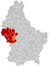 Map of Luxembourg with Useldange highlighted in orange, and the canton in dark red | ||
| Coordinates: 49°46′00″N 5°59′00″E / 49.7667°N 5.9833°ECoordinates: 49°46′00″N 5°59′00″E / 49.7667°N 5.9833°E | ||
| Country |
| |
| Canton | Redange | |
| Government | ||
| • Mayor | Léon Bodem | |
| Area | ||
| • Total | 23.92 km2 (9.24 sq mi) | |
| Area rank | 36 of 102 | |
| Highest elevation | 377 m (1,237 ft) | |
| • Rank | 73rd of 102 | |
| Lowest elevation | 232 m (761 ft) | |
| • Rank | 45th of 102 | |
| Population (2014) | ||
| • Total | 1,639 | |
| • Rank | 80th of 102 | |
| • Density | 69/km2 (180/sq mi) | |
| • Density rank | 78th of 102 | |
| Time zone | UTC+1 (CET) | |
| • Summer (DST) | UTC+2 (CEST) | |
| LAU 2 | LU00003008 | |
| Website | useldange.lu | |

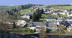
Useldange (Luxembourgish: Useldeng, German: Useldingen) is a commune and small town in western Luxembourg, in the canton of Redange.
As of 2005, the town of Useldange, which lies in the east of the commune, has a population of 622. Other towns within the commune include Everlange, Rippweiler, and Schandel.
Useldange Castle is a medieval castle, which, while now being mainly in ruin, also comprises the current townhall. It is located in the centre of the village, right opposite to the town's church building. The site can be visited throughout the year with special arrangements for poorly sighted visitors.[1]

Useldange Castle
Useldange also has an airfield used by gliders (49°46′07″N 5°57′56″E / 49.768611°N 5.965556°E).
References
- ↑ "Château fort d'Useldange", Service des Sites et Monuments Nationaux. (in French) Retrieved 26 March 2011.
External links

Places adjacent to Useldange | ||||||||||
|---|---|---|---|---|---|---|---|---|---|---|
| ||||||||||
 | ||
| Authority control |
|---|
This article is issued from
Wikipedia.
The text is licensed under Creative Commons - Attribution - Sharealike.
Additional terms may apply for the media files.