Uralla Shire
| Uralla Shire New South Wales | |||||||||||||||
|---|---|---|---|---|---|---|---|---|---|---|---|---|---|---|---|
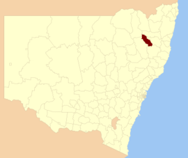 Location in New South Wales | |||||||||||||||
| Coordinates | 30°39′S 151°30′E / 30.650°S 151.500°ECoordinates: 30°39′S 151°30′E / 30.650°S 151.500°E | ||||||||||||||
| Population | 6,048 (2016 census)[1] | ||||||||||||||
| • Density | 1.8724/km2 (4.850/sq mi) | ||||||||||||||
| Established | 1948 | ||||||||||||||
| Area | 3,230 km2 (1,247.1 sq mi) | ||||||||||||||
| Mayor | Michael Pearce (Independent) | ||||||||||||||
| Council seat | Uralla[2] | ||||||||||||||
| Region | New England | ||||||||||||||
| State electorate(s) | Northern Tablelands | ||||||||||||||
| Federal Division(s) | New England | ||||||||||||||
| Website | Uralla Shire | ||||||||||||||
| |||||||||||||||
Uralla Shire is a local government area located in the New England region of New South Wales, Australia. The New England Highway passes through the Shire.
The Shire was established in 1948 as a rsult of the amalgamation of the Municipality of Uralla with the surrounding Gostwyck Shire.[3]
The Mayor of Uralla Shire Council is Cr. Michael Pearce, an independent politician.
Towns and villages
The towns and villages of Uralla Shire include Uralla, Bundarra, Yarrowyck, Kingstown, Kentucky Invergowrie and Wollun.
Heritage listings
The Uralla Shire has a number of heritage-listed sites, including:
- Bundarra, Oliver Street: Bundarra Police Station and Courthouse[4]
- Kentucky District: Captain Thunderbolt's Death Site[5]
- Uralla, 6 East Street: New England Brass and Iron Lace Foundry[6]
- Uralla, Main Northern railway: Uralla railway station[7]
- Uralla, Salisbury Street: McCrossins Mill[8]
- Uralla, Uralla Square: Captain Thunderbolt's Grave[9]
- Uralla, New England Highway: Blanch's Royal Oak Inn[10]
- Uralla, New England Highway: Captain Thunderbolt's Rock[11]
Demographics
According to the Australian Bureau of Statistics[12] there:
- were 6,126 people as at 30 June 2006, the 122nd largest Local Government Area in New South Wales. It was equal to less than 0.1% of the New South Wales population of 6,827,694
- was an increase of 56 people over the year to 30 June 2006, the 101st largest population growth in a Local Government Area in New South Wales. It was equal to 0.1% of the 58,753 increase in the population of New South Wales
- was, in percentage terms, an increase of 0.9% in the number of people over the year to 30 June 2006, the 55th fastest growth in population of a Local Government Area in New South Wales. In New South Wales the population grew by 0.9%
- was an increase in population over the 10 years to 30 June 2006 of 78 people or 1.3% (0.1% in annual average terms), the 94th highest rate of a Local Government Area in New South Wales. In New South Wales the population grew by 622,966 or 10% (1.0% in annual average terms) over the same period.
Incomes
According to the Australian Bureau Statistics[13] during 2003-04, there:
- were 1,865 wage and salary earners (ranked 118th in New South Wales and 381st in Australia, less than 0.1% of both New South Wales's 2,558,415 Australia's 7,831,856)
- was a total income of around $58 million (ranked 118th in New South Wales and 384th in Australia, less than 0.1% of both New South Wales's $107 billion and Australia's $304 billion)
- was an estimated average income per wage and salary earner of $31,071 (ranked 128th in New South Wales and 435th in Australia, 75% of New South Wales's $41,407 and 80% of Australia's $38,820)
- was an estimated median income per wage and salary earner of $28,396 (ranked 140th in New South Wales and 461st in Australia, 80% of New South Wales's $35,479 and 83% of Australia's $34,149).
Council
Current composition and election method
Uralla Shire Council is composed of nine Councillors elected proportionally as three separate wards, each electing three Councillors. All Councillors are elected for a fixed four-year term of office. The Mayor is by the Councillors at the first meeting of the Council. The most recent election was held on 8 September 2012 and the makeup of the Council is as follows:[14][15][16]
| Party | Councillors | |
|---|---|---|
| Independent and Unaligned | 9 | |
| Total | 9 | |
The current Council, elected in 2012, in order of election by ward, is:
| Ward | Councillor | Party | Notes | |
|---|---|---|---|---|
| Ward A[14] | Bob Crouch | Independent | Deputy Mayor[17] | |
| Michael Pearce | Unaligned | Mayor[17] | ||
| Mark Dusting | Independent | |||
| Ward B[15] | Kevin Ward | Unaligned | ||
| Fred Geldof | Unaligned | |||
| Daphne Field | Independent | |||
| Ward C[16] | Isabell Strutt | Independent | ||
| Leanne Cooper | Independent | |||
| Karen Dusting | Independent | |||
At the 2012 local government elections, a referendum was held to directly elect they Mayor and reduce the number of Wards from three to two, each electing four Councillors. The referendum was passed, with 55.96% voting in favour of the resolution.[18] The changes will take place at the next local government elections, due to be held in 2016.
Proposed amalgamation
A 2015 review of local government boundaries recommended that the Armidale Dumaresq Shire and the Guyra Shire councils merge.[19] An alternative proposal, submitted by the Armidale Dumaresq Council on 1 March 2016, was for an amalgamation of the Armidale Dumaresq, Guyra, Uralla and Walcha councils.[20] The outcome of the independent review is expected by mid–2016.
References
- ↑ Australian Bureau of Statistics (27 June 2017). "Uralla (A)". 2016 Census QuickStats. Retrieved 8 December 2017.

- ↑ "Uralla Shire Council". Department of Local Government. Retrieved 17 June 2011.
- ↑ "Municipal District of Uralla (1882-1906) Municipality of Uralla (1906-1947) Council". Search. State Records NSW. Retrieved 21 May 2016.
- ↑ "Bundarra Police Station & Courthouse, New South Wales State Heritage Register (NSW SHR) Number H00229". New South Wales State Heritage Register. Office of Environment and Heritage. Retrieved 18 May 2018.
- ↑ "The Captain Thunderbolt Sites - Thunderbolt's Death Site, New South Wales State Heritage Register (NSW SHR) Number H01889". New South Wales State Heritage Register. Office of Environment and Heritage. Retrieved 2 June 2018.
- ↑ "New England Brass and Iron Lace Foundry, New South Wales State Heritage Register (NSW SHR) Number H01455". New South Wales State Heritage Register. Office of Environment and Heritage. Retrieved 18 May 2018.
- ↑ "Uralla Railway Station group, New South Wales State Heritage Register (NSW SHR) Number H01275". New South Wales State Heritage Register. Office of Environment and Heritage. Retrieved 18 May 2018.
- ↑ "McCrossins Mill, New South Wales State Heritage Register (NSW SHR) Number H00161". New South Wales State Heritage Register. Office of Environment and Heritage. Retrieved 18 May 2018.
- ↑ "The Captain Thunderbolt Sites - Thunderbolt's Grave, New South Wales State Heritage Register (NSW SHR) Number H01889". New South Wales State Heritage Register. Office of Environment and Heritage. Retrieved 18 May 2018.
- ↑ "The Captain Thunderbolt Sites - Blanch's Royal Oak Inn, New South Wales State Heritage Register (NSW SHR) Number H01889". New South Wales State Heritage Register. Office of Environment and Heritage. Retrieved 18 May 2018.
- ↑ "The Captain Thunderbolt Sites - Thunderbolt's Rock, New South Wales State Heritage Register (NSW SHR) Number H01889". New South Wales State Heritage Register. Office of Environment and Heritage. Retrieved 18 May 2018.
- ↑ "Regional Population Growth, Australia, 2005-06 (catalogue no.: 3218.0)". Australian Bureau of Statistics. Retrieved 12 March 2007.
- ↑ "Regional Wage and Salary Earner Statistics, Australia (catalogue no.: 5673.055.003)". Australian Bureau of Statistics. Retrieved 11 March 2007.
- 1 2 "Uralla Council - A Ward: Summary of First Preference Votes for each Candidate". Local Government Elections 2012. Electoral Commission of New South Wales. 14 September 2012. Retrieved 12 October 2012.
- 1 2 "Uralla Council - B Ward: Summary of First Preference Votes for each Candidate". Local Government Elections 2012. Electoral Commission of New South Wales. 14 September 2012. Retrieved 12 October 2012.
- 1 2 "Uralla Council - C Ward: Summary of First Preference Votes for each Candidate". Local Government Elections 2012. Electoral Commission of New South Wales. 15 September 2012. Retrieved 12 October 2012.
- 1 2 Denman, Elyse (20 September 2012). "New mayor for Uralla Shire Council". ABC News. Australia. Retrieved 12 October 2012.
- ↑ "Uralla Council - Referendum". Local Government Elections 2012. Electoral Commission of New South Wales. 14 September 2012. Retrieved 12 October 2012.
- ↑ "Merger proposal: Armidale Dumaresq Council and Guyra Shire Council" (PDF). Government of New South Wales. January 2016. p. 7. Retrieved 18 February 2016.
- ↑ Armidale Dumaresq Council (1 March 2016). "Merger proposal: Armidale Dumaresq Council, Guyra Shire Council, Uralla Shire Council and Walcha Council" (PDF). Government of New South Wales. Retrieved 7 March 2016.