Upper Sûre Lake
Upper Sûre Lake
| |
|---|---|
 | |
| Type | Reservoir |
| Designation | Nature reserve[1] |
| Construction engineer | André Coyne[2] |
| First flooded | 1959[2] |
| Surface area | 3.8 km2 (1.5 sq mi)[1] |
| Shore length1 | 48 km (30 mi)[1] |
| Website | Upper Sûre Lake |
| References | [1] [2] |
| Official name | Vallée de la Haute-Sûre |
| Designated | 8 March 2004 |
| Reference no. | 1407[3] |
| Official name | Vallée de la Haute-Sûre |
| Designated | 8 March 2004 |
| Reference no. | 1408[4] |
| 1 Shore length is not a well-defined measure. | |
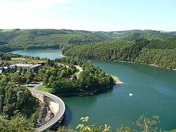
The Upper Sûre Lake (Luxembourgish: Stauséi Uewersauer, French: Lac de la Haute-Sûre, German: Stausee an der Ober-Sauer) is a large reservoir in north-western Luxembourg. It is the largest body of water in the country. It gives its name to the commune of Lac de la Haute-Sûre, which was formed in 1979.
History
It is created by the Esch-sur-Sûre Dam which was built in the 1950s to meet Luxembourg's drinking water and electricity needs. The town of Esch-sur-Sûre nestles at one end of the lake. Immediately above it, the river has been dammed to form a hydroelectric reservoir extending some 10 kilometres (6.2 mi) up the valley. Its average surface area is 3.8 km2 (1.5 sq mi), or about 0.15% of Luxembourg's total area.
Protected area
The region around the reservoir forms the Upper Sûre Natural Park, a Luxembourgish national park. The valley of the Upper Sûre surrounding the reservoir has been designated as a Ramsar site, in Luxembourg and in neighboring Belgium, since 2004.[3][4]
Recreation
Surrounded by luxuriant vegetation and peaceful creeks, the lake is a center for water sports, such as sailing, canoeing, and kayaking. Such outdoor activities, which make it an attractive spot for tourists, has led to the growth of a local crafts industry. The lake has a very high level of water quality.[5]
References
- 1 2 3 4 "Naturpark Öewersauer - Description". naturpark-sure.lu. Retrieved 30 May 2018.
- 1 2 3 "Présentation & Historique - SEBES". SEBES (in French). Retrieved 30 May 2018.
- 1 2 "Vallée de la Haute-Sûre". Ramsar Sites Information Service. Retrieved 25 April 2018.
- 1 2 "Vallée de la Haute-Sûre". Ramsar Sites Information Service. Retrieved 25 April 2018.
- ↑ "Water quality in the EU". European Commission. URL accessed 4 June 2006.
External links

Coordinates: 49°54′11″N 5°52′34″E / 49.903°N 5.876°E