Upper Nihotupu Reservoir
| Upper Nihotupu Reservoir | |
|---|---|
 Upper Nihotupu Dam | |
| Location | Auckland, North Island |
| Coordinates | 36°57′00″S 174°33′50″E / 36.95°S 174.5638°ECoordinates: 36°57′00″S 174°33′50″E / 36.95°S 174.5638°E |
| Type | Reservoir |
| Basin countries | New Zealand |
| Surface area | 12.5 ha (31 acres)[1] |
| Water volume | 2.2×10⁶ m3 (1,800 acre⋅ft)[1] |
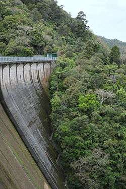
The Upper Nihotupu Reservoir (or Upper Nihotupu Dam) is one of five reservoirs in the Waitakere Ranges that supply water to Auckland, New Zealand. Completed in 1923,[1] the concrete gravity dam and its reservoir are managed by Water Care Services Limited, a council-owned company.
Construction
Construction was difficult due to the amount of rainfall and flooding in the area and spanned a total of 8 years. One person was killed during the construction of the bush tram line.
Tourism
The Nihotupu area and the picturesque Nihotupu Falls were a tourist attraction in the late 19th century before the dam for the reservoir was built.
A bush tram that was built during the construction of the dam and its water pipeline was used for the Water Care-run "Rainforest Express" tourist excursions. As at November 2014, the RFE is closed by Watercare until further notice along with the closure of the Waitakere Tramline simultaneously, by Watercare . Please enquire with Watercare for further information or look up Waitakere Tramline and NZ Regional Trains on facebook.The dam was the end point of the trips from Jacobson's Depot and can also be reached by walking track access from Piha Road. Steep steps lead up the face of the dam.
References
| Wikimedia Commons has media related to Upper Nihotupu Dam. |