Unionville, Worcester County, Maryland
| Unionville, Maryland | |
|---|---|
| Unincorporated community | |
 Unionville | |
| Coordinates: 38°03′38″N 75°35′57″W / 38.06056°N 75.59917°WCoordinates: 38°03′38″N 75°35′57″W / 38.06056°N 75.59917°W | |
| Country | United States |
| State | Maryland |
| County | Worcester |
| Elevation | 20 ft (6 m) |
| Time zone | UTC-5 (Eastern (EST)) |
| • Summer (DST) | UTC-4 (EDT) |
| Area code(s) | 410, 443 |
| GNIS feature ID | 591455[1] |
Unionville is an unincorporated community in Worcester County, Maryland, United States. Unionville is 2 miles (3.2 km) southwest of Pocomoke City.
References
Municipalities and communities of Worcester County, Maryland, United States | ||
|---|---|---|
| City | 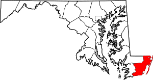 | |
| Towns | ||
| CDPs | ||
| Other communities | ||
| Footnotes | ‡This populated place also has portions in an adjacent county or counties | |
This article is issued from
Wikipedia.
The text is licensed under Creative Commons - Attribution - Sharealike.
Additional terms may apply for the media files.