Cedar Hall, Maryland
| Cedar Hall, Maryland | |
|---|---|
| Unincorporated community | |
 Cedar Hall | |
| Coordinates: 38°01′12″N 75°36′35″W / 38.02000°N 75.60972°WCoordinates: 38°01′12″N 75°36′35″W / 38.02000°N 75.60972°W | |
| Country | United States |
| State | Maryland |
| County | Worcester |
| Elevation | 7 ft (2 m) |
| Time zone | UTC-5 (Eastern (EST)) |
| • Summer (DST) | UTC-4 (EDT) |
| ZIP code | 21851 |
| Area code(s) | 410, 443, and 667 |
| GNIS feature ID | 583648[1] |
Cedar Hall is an unincorporated community in Worcester County, Maryland, United States.[1] Cedar Hall is located in the southwestern corner of the county along the Pocomoke River.
References
Municipalities and communities of Worcester County, Maryland, United States | ||
|---|---|---|
| City | 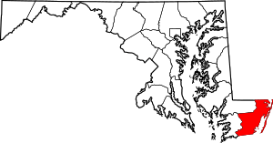 | |
| Towns | ||
| CDPs | ||
| Other communities | ||
| Footnotes | ‡This populated place also has portions in an adjacent county or counties | |
This article is issued from
Wikipedia.
The text is licensed under Creative Commons - Attribution - Sharealike.
Additional terms may apply for the media files.