Union Township, Union County, Indiana
| Union Township | |
|---|---|
| Township | |
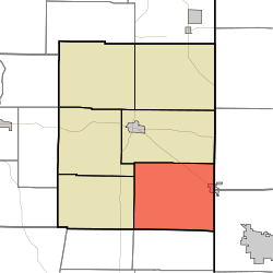 Location in Union County | |
| Coordinates: 39°33′53″N 84°52′30″W / 39.56472°N 84.87500°WCoordinates: 39°33′53″N 84°52′30″W / 39.56472°N 84.87500°W | |
| Country | United States |
| State | Indiana |
| County | Union |
| Government | |
| • Type | Indiana township |
| Area | |
| • Total | 30.51 sq mi (79.0 km2) |
| • Land | 30.43 sq mi (78.8 km2) |
| • Water | 0.08 sq mi (0.2 km2) 0.26% |
| Elevation[1] | 1,014 ft (309 m) |
| Population (2010) | |
| • Total | 1,622 |
| • Density | 53.3/sq mi (20.6/km2) |
| Time zone | UTC-5 (Eastern (EST)) |
| • Summer (DST) | UTC-4 (EDT) |
| ZIP codes | 47003, 47010, 47353 |
| Area code(s) | 765 |
| GNIS feature ID | 453936 |
Union Township is one of six townships in Union County, Indiana, United States. As of the 2010 census, its population was 1,622 and it contained 696 housing units.[2]
Geography
According to the 2010 census, the township has a total area of 30.51 square miles (79.0 km2), of which 30.43 square miles (78.8 km2) (or 99.74%) is land and 0.08 square miles (0.21 km2) (or 0.26%) is water.[2]
Cities and towns
Unincorporated towns
- Billingsville at 39°33′21″N 84°54′35″W / 39.5558837°N 84.9096808°W
- Charlottesville at 39°32′10″N 84°51′11″W / 39.5361624°N 84.8530123°W
(This list is based on USGS data and may include former settlements.)
Cemeteries
The township contains these three cemeteries: College Corner, Crawfords and Keiffer.
School districts
- Union County-College Corner Joint School District
Political districts
- Indiana's 6th congressional district
- State House District 55
- State Senate District 43
References
- United States Census Bureau 2007 TIGER/Line Shapefiles
- United States Board on Geographic Names (GNIS)
- IndianaMap
- ↑ "US Board on Geographic Names". United States Geological Survey. October 25, 2007. Retrieved 2017-05-09.
- 1 2 "Population, Housing Units, Area, and Density: 2010 - County -- County Subdivision and Place -- 2010 Census Summary File 1". United States Census. Retrieved 2013-05-10.
External links
Places adjacent to Union Township, Union County, Indiana | |
|---|---|
Municipalities and communities of Union County, Indiana, United States | ||
|---|---|---|
| Towns | ||
| Townships | ||
| Unincorporated communities | ||
This article is issued from
Wikipedia.
The text is licensed under Creative Commons - Attribution - Sharealike.
Additional terms may apply for the media files.