Union, Louisiana
| Union, Louisiana | |
|---|---|
| Unincorporated community | |
 Union, Louisiana  Union, Louisiana | |
| Coordinates: 30°05′14″N 90°54′17″W / 30.08722°N 90.90472°WCoordinates: 30°05′14″N 90°54′17″W / 30.08722°N 90.90472°W | |
| Country | United States |
| State | Louisiana |
| Parish | St. James |
| Area[1] | |
| • Total | 10.634 sq mi (27.54 km2) |
| • Land | 9.506 sq mi (24.62 km2) |
| • Water | 1.128 sq mi (2.92 km2) |
| Elevation | 23 ft (7 m) |
| Population (2010)[1] | |
| • Total | 892 |
| • Density | 84/sq mi (32/km2) |
| Time zone | UTC-6 (Central (CST)) |
| • Summer (DST) | UTC-5 (CDT) |
| Area code(s) | 225 |
| GNIS feature ID | 1628401[2] |
Union is an unincorporated community and census-designated place in St. James Parish, Louisiana, United States. Its population was 892 as of the 2010 census.[1] The community is located along Louisiana Highway 44 on the east bank of the Mississippi River.
Geography
According to the U.S. Census Bureau, the community has an area of 10.634 square miles (27.54 km2); 9.506 square miles (24.62 km2) of its area is land, and 1.128 square miles (2.92 km2) is water.[1]
References
- 1 2 3 4 "2010 Census Gazetteer Files - Places: Louisiana". U.S. Census Bureau. Retrieved January 17, 2017.
- ↑ "Union". Geographic Names Information System. United States Geological Survey.
Municipalities and communities of St. James Parish, Louisiana, United States | ||
|---|---|---|
| Towns | 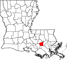 | |
| CDPs | ||
| Unincorporated community | ||
| Footnotes | ‡This populated place also has portions in an adjacent parish or parishes | |
This article is issued from
Wikipedia.
The text is licensed under Creative Commons - Attribution - Sharealike.
Additional terms may apply for the media files.