Ungkaya Pukan, Basilan
| Ungkaya Pukan | |
|---|---|
| Municipality | |
| Municipality of Ungkaya Pukan | |
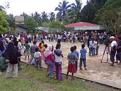 ABS-CBN Kapamilya Outreach program in Barangay Materling, Ungkaya Pukan, in 2009. | |
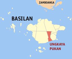 Map of Basilan with Ungkaya Pukan highlighted | |
.svg.png) Ungkaya Pukan Location within the Philippines | |
| Coordinates: 6°30′N 122°07′E / 6.5°N 122.12°ECoordinates: 6°30′N 122°07′E / 6.5°N 122.12°E | |
| Country |
|
| Region | Autonomous Region in Muslim Mindanao (ARMM) |
| Province | Basilan |
| District | Lone District |
| Founded | May 22, 2006 |
| Barangays | 12 (see Barangays) |
| Government [1] | |
| • Type | Sangguniang Bayan |
| • Mayor | Jomar M. Maturan |
| • Electorate | 9,015 voters (2016) |
| Area [2] | |
| • Total | 96.13 km2 (37.12 sq mi) |
| Population (2015 census)[3] | |
| • Total | 18,441 |
| • Density | 190/km2 (500/sq mi) |
| Time zone | UTC+8 (PST) |
| ZIP code | 7304 |
| PSGC | 150711000 |
| IDD : area code | +63 (0)62 |
| Climate type | Tropical climate |
| Income class | 5th municipal income class |
| Revenue (₱) | 58,392,640.57 (2016) |
| Native languages |
Yakan Chavacano Tagalog |
Ungkaya Pukan, officially the Municipality of Ungkaya Pukan, (Tausūg: Lupah Ungkaya Pukan; Chavacano: Municipalidad de Ungkaya Pukan; Tagalog: Bayan ng Ungkaya Pukan), is a 5th class municipality in the province of Basilan, Philippines. According to the 2015 census, it has a population of 18,441 people.[3]
Ungkaya Pukan was created by Muslim Mindanao Autonomy Act No. 190,[4] ratified by plebiscite on May 22, 2006. It is composed of 12 barangays that were formerly part of Tipo-Tipo.
Barangays
Ungkaya Pukan is politically subdivided into 12 barangays.[5]
| PSGC | Barangay | Population | ±% p.a. | |||
|---|---|---|---|---|---|---|
| 2015[3] | 2010[6] | |||||
| 150711001 | Amaloy | 6.1% | 1,129 | 980 | 2.73% | |
| 150711002 | Bohe-Pahuh | 7.8% | 1,437 | 1,499 | −0.80% | |
| 150711003 | Bohe-Suyak | 15.2% | 2,804 | 2,128 | 5.39% | |
| 150711004 | Cabangalan | 5.5% | 1,010 | 1,136 | −2.21% | |
| 150711005 | Danit | 4.4% | 818 | 824 | −0.14% | |
| 150711006 | Kamamburingan | 5.5% | 1,018 | 1,223 | −3.43% | |
| 150711007 | Matata | 6.3% | 1,170 | 1,041 | 2.25% | |
| 150711008 | Materling | 12.5% | 2,296 | 2,268 | 0.23% | |
| 150711009 | Pipil | 12.9% | 2,375 | 2,069 | 2.66% | |
| 150711010 | Sungkayut | 5.0% | 931 | 1,040 | −2.09% | |
| 150711011 | Tongbato | 7.8% | 1,446 | 1,371 | 1.02% | |
| 150711012 | Ulitan | 10.9% | 2,007 | 2,122 | −1.06% | |
| Total | 18,441 | 17,701 | 0.78% | |||
Demographics
| Population census of Ungkaya Pukan | ||
|---|---|---|
| Year | Pop. | ±% p.a. |
| 2007 | 30,472 | — |
| 2010 | 17,701 | −17.94% |
| 2015 | 18,441 | +0.78% |
| Source: Philippine Statistics Authority[3][6][7][8] | ||
In the 2015 census, Ungkaya Pukan had a population of 18,441.[3] The population density was 190 inhabitants per square kilometre (490/sq mi).
References
- ↑ "Municipality". Quezon City, Philippines: Department of the Interior and Local Government. Retrieved 31 May 2013.
- ↑ "Province: Basilan". PSGC Interactive. Quezon City, Philippines: Philippine Statistics Authority. Retrieved 12 November 2016.
- 1 2 3 4 5 Census of Population (2015). "ARMM – Autonomous Region in Muslim Mindanao". Total Population by Province, City, Municipality and Barangay. PSA. Retrieved 20 June 2016.
- ↑ "Muslim Mindanao Autonomy Act No. 190; An Act Creating the Municipality of Ungkaya Pukan in the Province of Basilan and for Other Purposes" (PDF). Regional Legislative Assembly, Autonomous Region in Muslim Mindanao. Archived from the original (PDF) on 4 February 2016. Retrieved 27 January 2016.
- ↑ "Municipal: Ungkaya Pukan, Basilan". PSGC Interactive. Quezon City, Philippines: Philippine Statistics Authority. Retrieved 8 January 2016.
- 1 2 Census of Population and Housing (2010). "ARMM – Autonomous Region in Muslim Mindanao". Total Population by Province, City, Municipality and Barangay. NSO. Retrieved 29 June 2016.
- ↑ Censuses of Population (1903–2007). "ARMM – Autonomous Region in Muslim Mindanao". Table 1. Population Enumerated in Various Censuses by Province/Highly Urbanized City: 1903 to 2007. NSO.
- ↑ "Province of Basilan". Municipality Population Data. Local Water Utilities Administration Research Division. Retrieved 17 December 2016.
Places adjacent to Ungkaya Pukan, Basilan | ||||||||||
|---|---|---|---|---|---|---|---|---|---|---|
| ||||||||||
Lamitan (capital) | ||
| Municipalities |  | |
| Component cities |
| |
This article is issued from
Wikipedia.
The text is licensed under Creative Commons - Attribution - Sharealike.
Additional terms may apply for the media files.