Undercliffe, New South Wales
| Undercliffe Sydney, New South Wales | |
|---|---|
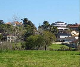 Undercliffe, view from Waterworth Park | |
| Postcode(s) | 2206 |
| Location | 10 km (6 mi) south-west of Sydney CBD |
| LGA(s) | Canterbury-Bankstown Council |
| State electorate(s) | Canterbury |
| Federal Division(s) | Barton |
Undercliffe is an area in the east of the suburb of Earlwood in south-western Sydney, in the state of New South Wales, Australia. Undercliffe is located 10 kilometres south-west of the Sydney central business district in the local government area of the Canterbury-Bankstown Council.
Undercliffe was a suburb of Sydney until incorporation into Earlwood in 1993.[1]
Undercliffe is located on the peninsula between the Cooks River and Wolli Creek. Bayview Avenue and Unwins Bridge link Undercliffe north over the Cooks River to Tempe. Another bridge links Illawarra Avenue over the Cooks River to Marrickville. Wolli Creek and Turrella are located on the opposite bank of Wolli Creek, to the south, with footbridges being the only direct links to these suburbs.
Landmarks
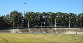
Undercliffe is a predominantly residential area. The northern end of the peninsula is characterised by parkland and recreational areas. Canterbury Velodrome is located at Waterworth Park, beside Wolli Creek. Gough Whitlam Park is a large recreational area, beside Cooks River. The popular Cooks River bicycle track follows the river along its northern bank connecting the suburb with Homebush to the north-west and Botany Bay to the east.
Undercliffe Public School is located in Bayview Avenue. The Transfiguration of Our Lord Greek Orthodox Church is also located in Bayview Avenue.
History
Undercliffe takes its name from the heavy sandstone outcrop which is quite evident. The Undercliffe Estate was the name of an 1840s land grant which had a house built on it. In the early days, the quarrying of sandstone between Wolli Creek and Cooks River provided the first industry here. Some homes were built completely from sandstone, while almost all others used sandstone for their foundations. Amongst notable land owners in the area was retired East India Company Judge James Donnithorne (1773-1852) who owned shares in the Undercliffe Estate, which upon his death were passed to his daughter Eliza Emily (1826-1886) a recluse who leased out the land until her death. It was then sold and eventually subdivided for housing.
A wooden bridge was built across the Cooks River in 1836 to carry the Illawarra Road across the river. It was known as Tompsons Bridge, after Mr P. A. Tompson's father who purchased the Bexley estate from James Chandler. The bridge was washed away several times during floods. later, Frederick Wright Unwin, a Sydney Solicitor, built a bridge on the peninsula between Cooks River and Wolli Creek to provide access to his property. Unwin had bought his property from Arthur Martin in 1840 and built a large home known as Wanstead, after a village in Essex, England. Unwins Bridge, Unwins Bridge Road, Wanstead Avenue and Wanstead Avenue Reserve commemorate these names. Waterworth Park was set aside as a reserve in 1906 when it was declared unhealthy and unsuitable for residences.[2]
Between 1912 and 1957, electric trams operated through Undercliffe along Illawarra Road and Homer Street on their way to the west of Earlwood, providing service to the city via Marrickville and Newtown.[3] The service is now operated by buses.
Heritage listings
Undercliffe has a number of heritage-listed sites, including:
- Pine Street: Cooks River Sewage Aqueduct[4]
- Unwin Street: Wolli Creek Aqueduct[5]
References
- ↑ "Undercliffe". Geographical Names Register (GNR) of NSW. Geographical Names Board of New South Wales. Retrieved 11 August 2013.
- ↑ The Book of Sydney Suburbs, Compiled by Frances Pollen, Angus & Robertson Publishers, 1990, Published in Australia ISBN
- ↑ Keenan, D., Tramways of Sydney. Transit Press 1979
- ↑ "Cooks River Sewage Aqueduct, New South Wales State Heritage Register (NSW SHR) Number H01322". New South Wales State Heritage Register. Office of Environment and Heritage. Retrieved 18 May 2018.
- ↑ "Wolli Creek Aqueduct, New South Wales State Heritage Register (NSW SHR) Number H01355". New South Wales State Heritage Register. Office of Environment and Heritage. Retrieved 18 May 2018.
Coordinates: 33°55′35″S 151°08′37″E / 33.92648°S 151.14368°E