Uelversheim
| Uelversheim | ||
|---|---|---|
| ||
 Uelversheim Location of Uelversheim within Mainz-Bingen district  | ||
| Coordinates: 49°48′36″N 08°17′18″E / 49.81000°N 8.28833°ECoordinates: 49°48′36″N 08°17′18″E / 49.81000°N 8.28833°E | ||
| Country | Germany | |
| State | Rhineland-Palatinate | |
| District | Mainz-Bingen | |
| Municipal assoc. | Rhein-Selz | |
| Government | ||
| • Mayor | Stefan Ebling (SPD) | |
| Area | ||
| • Total | 7.49 km2 (2.89 sq mi) | |
| Elevation | 190 m (620 ft) | |
| Population (2017-12-31)[1] | ||
| • Total | 1,094 | |
| • Density | 150/km2 (380/sq mi) | |
| Time zone | CET/CEST (UTC+1/+2) | |
| Postal codes | 55278 | |
| Dialling codes | 06249 | |
| Vehicle registration | MZ | |
| Website | www.uelversheim.com | |


Uelversheim is an Ortsgemeinde – a municipality belonging to a Verbandsgemeinde, a kind of collective municipality – in the Mainz-Bingen district in Rhineland-Palatinate, Germany.
Geography
Uelversheim lies between Mainz and Worms, in the “Heart of Rhenish Hesse”, and belongs to the Berggemeinden (“Mountain Municipalities”, besides Uelversheim these are the neighbouring centres of Weinolsheim, Dolgesheim and Eimsheim)
Uelversheim is a typical winegrowing centre, with almost a fourth of its area given over to this pursuit. Wine is also grown in an exclave between Dienheim and Guntersblum, which along with the actual community forms part of Uelversheim’s municipal area.
History
In 766, Uelversheim had its first documentary mention. Digs, however, confirm that the area was earlier substantially settled by Celts and Germanic peoples.
Over lengthy times in the Middle Ages, the place belonged to the Counts of Leiningen who built a castle here as a summer residence.
Government
Uelversheim is part of the Verbandsgemeinde Rhein-Selz.
The Municipal Council is made up of 17 council members, counting the part-time mayor, with seats apportioned thus:
| CDU | SPD | FWG | Total | |
| 2004 | 5 | 7 | 4 | 16 seats |
(as of municipal election held on 13 June 2004)
Elections in 2014:
- CDU: 9 seats
- SPD: 7 seats
Culture and sightseeing
Buildings
The Evangelical church was built in 1722 by a master builder from Freiburg in the unique shape of a regular octagon. It is to this unusual church that the Uelversheim nickname die Merkwerdische can be traced, merkwerdisch being a local variation of the German word merkwürdig – “odd”.
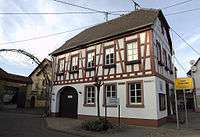
Today’s Town Hall is a timber-frame house built in the Baroque style.
Regular events
The village’s well known festivals are Fassenacht with two regularly sold-out “sessions”, the Sport Week held by TSV Uelversheim with the Traditionsjedermannturnier (“Traditional Everyman Tournament”), the kermis (church consecration festival, locally known as the Kerb) with its famous kermis parade and kermis youth, the Keller-Dudde-Fest organized by the men’s singing club and the AVT-Hakorennen (race) held every other year.
Transport
The nearest Autobahn interchange is Wörrstadt on the A 63, some 12 km away.
References
- ↑ Statistisches Landesamt Rheinland-Pfalz "Bevölkerungsstand 2017 - Gemeindeebene" Check
|url=value (help). Statistisches Landesamt Rheinland-Pfalz (in German). 2018.
External links

- Municipality’s official webpage (in German)