Twin Rivers, East Riding of Yorkshire
| Twin Rivers | |
|---|---|
| Civil parish | |
 | |
| Coordinates: 53°41′N 0°44′W / 53.683°N 0.733°WCoordinates: 53°41′N 0°44′W / 53.683°N 0.733°W | |
| Country | England |
| Primary council | East Riding of Yorkshire |
| Region | Yorkshire and the Humber |
| Status | Parish |
| Government | |
| • Type | Parish Council |
| • UK Parliament | Brigg and Goole |
| • EU Parliament | Yorkshire and the Humber |
| Population (2011 census)[1] | |
| • Total | 367 |
| Website | Twin Rivers Parish Council |
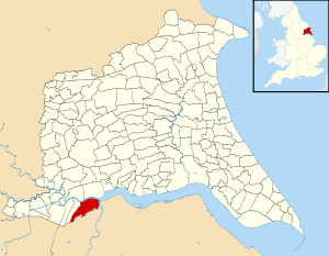
Twin Rivers is a civil parish in the East Riding of Yorkshire, England. It is situated along the south bank of the River Ouse to the east of the town of Goole, covering an area of 2,403.178 hectares (5,938.38 acres).[2]
The civil parish is formed by the village of Adlingfleet and the hamlets of Ousefleet and Whitgift.
According to the 2011 UK census, Twin Rivers parish had a population of 367,[1] an increase on the 2001 UK census figure of 357.[3]
References
- 1 2 UK Census (2011). "Local Area Report – Twin Rivers Parish (1170211279)". Nomis. Office for National Statistics. Retrieved 26 February 2018.
- ↑ "2001 Census Area Profile" (PDF). East Riding of Yorkshire Council. 2004. Archived (PDF) from the original on 18 March 2012. Retrieved 8 February 2013.
- ↑ "Neighbourhood Statistics - Area: Twin Rivers CP (Parish)". Neighbourhood Statistics. Office for National Statistics. Retrieved 12 March 2008.
- Gazetteer — A–Z of Towns Villages and Hamlets. East Riding of Yorkshire Council. 2006. p. 11.
External links
![]()
This article is issued from
Wikipedia.
The text is licensed under Creative Commons - Attribution - Sharealike.
Additional terms may apply for the media files.