Turnpike trusts in Greater Manchester
Turnpike trusts were bodies set up by Acts of Parliament in the United Kingdom during the 18th and 19th centuries. The trusts had powers to collect road tolls for the maintenance of principal highways. The length of turnpike roads within what is now Greater Manchester varied considerably, from the 0.5 miles (0.80 km) Little Lever Trust,[1] to the 22 miles (35 km) Manchester to Saltersbrook Trust.[2]
Turnpikes contributed significantly to England's economic development before and during the Industrial Revolution. Although the trusts were abolished in the late-19th century, the roads themselves broadly remain as modern routes, and some of the original toll houses and roadside milestones have survived.
The metropolitan county of Greater Manchester was created in 1974 and so the turnpike trusts predate its existence. Greater Manchester lies at the conjunction of the historic county boundaries of Cheshire, Derbyshire, Lancashire and Yorkshire; many trusts operated roads which crossed those ancient county boundaries. The list below is divided according to historic county, with the first part of the name of each trust determining which table it appears in.
History
Method of construction and the design of the road surface varied. Before construction of its road, the Bury, Blackburn and Whalley Trust engaged "skilled persons" as temporary surveyors, to make a survey of the districts through which the road would pass. It then advertised for tenders for construction of varied parts of the roads, with contractors responsible for building their respective portions, under the supervision of permanent surveyors.[3] The trust bought limestone for the road surface largely from limestone quarries in Clitheroe.[4] In Manchester, Liverpool, and Wigan, due to heavy coal traffic it was necessary to lay pavements of large stones along the roads. Suitable material would, if not found in the vicinity, be imported from the coasts of Wales and Scotland. Normally the pavement ran down the middle of the road, with a gravelled way on either side. An exception was along Bury New Road (built in 1826), where the middle track was 4 yards (3.7 m) of gravel, with stone pavements 3 yards (2.7 m) outside it. Such pavements were expensive, and unpopular with travellers who regularly described their discomfort travelling upon them.[5]
Toll rates varied across the region, but preferential rates were often available to local residents, and for particular kinds of local traffic. The 1819 Act of the Crossford Bridge and Manchester Trust allowed it to charge half tolls on the inhabitants and occupiers of Trafford House, Old Trafford, and Stretford Moss. The Bolton and Westhoughton Trust allowed farmers from Rumworth and Westhoughton to use the roads free of charge, when taking horses and carts laden with produce from their own farms to Bolton Market. Carriage of coal was often charged at half the normal rate, and no tolls were payable by persons travelling on foot. Other road users who were entitled to free passage included posthorses, carriage of ordnance and military stores, and cattle going to pasture.[6]
Turnpike roads had a huge impact on the nature of business transport around Manchester. Packhorses were superseded by waggons, and merchants would no longer accompany their caravans to markets and fairs, instead sending agents with samples, and despatching the goods at a later date. In 1804 it was said that Manchester employed more than 120 "land carriers".[7]
The railway era spelt disaster for most turnpike trusts. Although some trusts in districts not served by railways managed to increase revenue, most did not. In 1829, the year before the Liverpool and Manchester Railway opened, the Warrington and Lower Irlam Trust had receipts of £1,680, but by 1834 this had fallen to £332. The Bolton and Blackburn Trust had an income of £3,998 in 1846, but in 1847 following the completion of a railway between the two towns this had fallen to £3,077, and in 1849 £1,185.[8]
The end of the turnpike system created serious problems for the local parishes and highway district boards upon whom the burden of maintenance fell. The Local Government Act 1888 made the repair of all main roads the responsibility of the new County Councils. Lancashire County Council determined that any road leading to a town with a population of 25,000 or more would become a main road, which included almost all of the old turnpike roads in the region.[9]
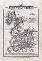 An 1814 map of Lancashire by John Cary which shows many of the Turnpike roads.
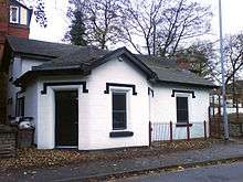 The Grade II listed Kersal Bar Toll House,[10] along the Manchester and Bury New Road Turnpike road.
 A milestone along the Warrington and Lower Irlam Turnpike road, near Rixton. The opposite side gives the distance to Warrington.
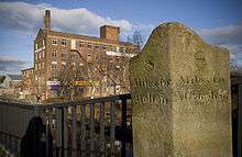 A milestone on Patricroft Bridge, along the Barton and Moses Gate Turnpike road, near Eccles. Note the older spelling of 'Altringham' - latterly Altrincham.
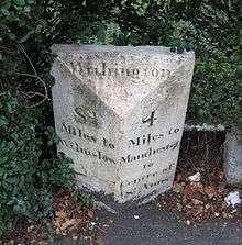 A milestone along the Manchester to Wilmslow Turnpike road, in Withington
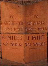 This milestone, part of the Smut Inn public house, indicates the distance between Oldham and Manchester Town Hall.
Cheshire
| Name | Interest | Income | Length | Main Gates | Side gates | Act | Year | date expired | county | modern road(s) |
|---|---|---|---|---|---|---|---|---|---|---|
| Cranage Green to Altrincham | 26 Geo. II, c. 26[11] | 1753[11] | 1881[12] | Cheshire | ||||||
| Stockport to Marple Bridge | 10 miles (16 km) (1852)[13] | 5[13] | 1 (chain)[13] | 41 Geo. III, c. 98[14] | 1801[14] | Cheshire & Derbys | ||||
| Washway (Crossford Bridge to Altringham)[17] | 3 miles, 4 furlongs, 164 yards (5.8 km) (1852)[18] |
Derbyshire
| Name | Interest | Income | Length (1848) | Main Gates | Side gates | Act | Year | date expired | county | modern road(s) |
|---|---|---|---|---|---|---|---|---|---|---|
| Glossop to Marple Bridge | 43 Geo III. c. 18[14] | 1803[14] | Derbys |
Lancashire
| Name | Interest | Income | Length (1848) | Main Gates | Side gates | Act | Year | Year ended | county | modern road(s) |
|---|---|---|---|---|---|---|---|---|---|---|
| Adlington and Westhoughton Trust | £201, 14s, 10d[19] | Lancs | ||||||||
| Ashton and Platt Bridge | £175 13s 6d[19] | 3 miles 4 furlongs (5.6 km)[21] | 46 Geo III. c. 2[22] | 1806[22] | Lancs | |||||
| Ashton under Lyne to Saddleworth | 7 Geo. IV c. 21[24] | 1826[24] | Lancs & Yorks | |||||||
| Barton Bridge and Moses Gate | £933 13s 4d[19] | 13 miles 1 furlong 110 yards (21.2 km)[21] | ||||||||
| Barton Bridge and Stretford | £300 19s[19] | 4 miles 3 furlongs 2 yards (7 km)[21] | 51 Geo III. c. 31[22] | 1811[22] | Lancs | Barton Road, Stretford (partial)[25] | ||||
| Bolton and Blackburn | £1,267 6d[19] | 12 miles 5 furlongs 41 yards (20.4 km)[21] | ||||||||
| Bolton and Nightingale | £1,755 10s 9d[19] | 19 miles (30.6 km)[21] | B6226 Smithills Dean Road Colliers Row Road Scout Road[23] | |||||||
| Bolton and St Helens | 17 miles 2 furlongs 44 yards (27.8 km)[21] | 5[26] | 8[26] | B5215[23] | ||||||
| Bolton and Westhoughton | 2 miles 7 furlongs (4.6 km)[21] | Bolton Road | ||||||||
| Bolton to Haslingdon (dormant) | 6 Geo IV. c. 92[27] | 1825[27] | Dormant | Lancs | ||||||
| Bolton to Leigh | 2 Geo III. c. 44[28] | 1762[28] | Lancs | |||||||
| Burnley to Tottington | 32 Geo III. c. 146[29] | 1795[29] | Lancs | |||||||
| Bury to Little Bolton | 5 miles 4 furlongs 176 yards (9 km)[21] | 3[30] | 4[30] | 1 & 2 Geo IV. c. 90[31] | 1821[31] | Lancs | ||||
| Bury to Blackburn, Whalley etc. | 33 miles 5 furlongs 9 yards (54.1 km)[21] | |||||||||
| Bury to Haslingden to Blackburn | 29 Geo III. c. 107[32] | 1789[32] | Lancs | |||||||
| Dryclough, Shaw, Rochdale | 10 miles 7 furlongs 102 yards (17.6 km)[21] | 1805[34] | Lancs | |||||||
| Eccles to Farnworth | ||||||||||
| Edenfield and Little Bolton | 1797[35] | B6213[20] | ||||||||
| Edenfield Chapel and Bury Bridge | ||||||||||
| Elton and Blackburn | 12 miles 6 furlongs (20.5 km)[21] | B6214[33] | ||||||||
| Gilda Brook and Irlam | 7 miles 7 furlongs 173 yards (12.8 km)[21] | B5320[25] | ||||||||
| Heath Charnock to Bolton | 3 Geo III. c. 31[36] | 1763[36] | Lancs | |||||||
| Heywood to Heaton | 29 Geo III. c. 110[32] | 1789[32] | ||||||||
| Hulme and Eccles | 3 miles 5 furlongs 214 yards (6 km)[21] | 46 Geo III.[37] | 22 March 1806[37] | Lancs | ||||||
| Hulme and Stretford | 5 miles 4 furlongs 183 yards (9 km)[21] | |||||||||
| Hulton | 5 miles 20 yards (8.1 km)[21] | |||||||||
| Ince, Hindley and Westhoughton | 6 miles (9.7 km)[21] | |||||||||
| Irlam's-o'-th'-Heights | 3 miles 7 furlongs 87 yards (6.3 km)[21] | |||||||||
| Little Lever | 4 furlongs (0.8 km)[2] | 1[38] | 5 Geo. IV c. 143[38] | 1824[38] | 1849 (disturnpiked)[38] | |||||
| Manchester and Ashton under Lyne | 3 miles 7 furlongs (6.2 km)[2] | 6 Geo. IV c. 51[24] | 1825[24] | Lancs | ||||||
| Manchester and Bury | ||||||||||
| Manchester and Oldham and Austerlands | 19 miles 1 furlong (30.8 km)[2] | 8 Geo. II c. 3[39] | 1735[27][39][40] | 1880[12] | Lancs & Yorks | |||||
| Manchester to Bolton | ||||||||||
| Manchester to Newton Chapel (dormant) | 57 Geo III. c. 47[27] | 1817[27] | Dormant | Lancs | ||||||
| Manchester to Pilkington | ||||||||||
| Manchester to Rochdale, Bury and Radcliffe | 5 miles 7 furlongs (9.5 km)[2] | 28 Geo II. c. 58[41] | 1755[41] | 1873-80[12] | Lancs | |||||
| Manchester to Saltersbrook | 22 miles (35.4 km)[2] | 5 Geo II. c. 10[39] | 1732[27][39] | 1884[12] | Lancs & Cheshire | |||||
| Manchester, Denton, Stockport | 58 Geo III. c. 6[31] | 1818[31] | Lancs & Cheshire | |||||||
| Mather Fold and Hardmans, Moses Gate District | 3 miles 2 furlongs (5.2 km)[2] | |||||||||
| Mather Fold and Hardmans, Ringley District | 3 miles 6 furlongs (6 km)[2] | |||||||||
| Pendleton Trust Agecroft District | £300[19] | 4 miles 187 yards (6.6 km)[21] | Moor Lane Singleton Road[20] | |||||||
| Pendleton Trust Irlam's-o'-th'-Heights District | ||||||||||
| Pendleton Trust Pendleton District | 2 miles 2 furlongs (3.6 km)[2] | |||||||||
| Pendleton Trust Swinton District | 5 miles 2 furlongs (8.5 km)[2] | |||||||||
| Prestwich and Bury | 5 miles 3 furlongs (8.7 km)[2] | Stand Lane[20] | ||||||||
| Radcliffe | 6 miles 1 furlongs (9.9 km)[2] | |||||||||
| Rochdale and Burnley | 18 miles 4 furlongs (29.8 km)[2] | 28 Geo II. c. 53[41] | 1755[41] | 1880[12] | Lancs | |||||
| Rochdale and Edenfield | 7 miles (11.3 km)[2] | 34 Geo III. c. 124[29] | 1794[29] | Lancs | ||||||
| Rochdale and Manchester, Manchester District | ||||||||||
| Rochdale and Manchester, Rochdale District | ||||||||||
| Rochdale, Bamford and Bury | 7 miles 4 furlongs (12.1 km)[2] | 1797[34] | 1866[43] | Lancs | Norden Road Bagslate Moor Road[33] | |||||
| Salford to Wigan | 26 Geo II. c. 27[11] | 1753[11] | Lancs | |||||||
| Sharples and Hoghton | 10 miles 4 furlongs (16.9 km) (1848)[2] | 3 (1852)[2] | 41 Geo III. c. 123[44] | |||||||
| Standedge and Oldham | 10 miles 7 furlongs (17.5 km)[2] | |||||||||
| Stretford to Manchester | 24 Geo II. c. 13[45] | 1751[45] | 1872[12] | Lancs | ||||||
| Sudden Bridge to Bury | 4 miles 6 furlongs (7.6 km)[2] | 1797[34] | Lancs | |||||||
| Swinton District | 5 miles 2 furlongs (8.4 km)[2] | |||||||||
| Warrington and Lower Irlam | 7 miles 5 furlongs (12.3 km)[2] | |||||||||
| Warrington and Wigan | 11 miles 2 furlongs (18.1 km)[2] | 13 Geo I. c. 10[46] | 1727[46] | Lancs | ||||||
| Radcliffe to Bolton & Bury | 6&7 Wm IV. c. 10[47] | 1836[47] | Lancs | |||||||
| Wigan and Preston, south of (River) Yarrow | 12 miles 6 furlongs (20.5 km)[2] | 13 Geo I. c. 9[46] | 1727[46] | 1866-67[12] | Lancs | |||||
| Manchester and Buxton | 11 Geo. I c.13[46] | 1725[27][40][46] | 1860-75[12] | Lancs & Derbys | ||||||
| Stockport and Ashton | 5 Geo. III c.100[36] | 1765[36] | Lancs & Cheshire | |||||||
| Stockport and Warrington | 1 Geo. IV, c. 28[48] | 1820[48] | Lancs & Cheshire | |||||||
| Stockport and Warrington (Edgley Branch) | ||||||||||
| Wilmslow | 26 Geo II.[50] | 1753[50] | 1881[12][50] | Lancs & Cheshire | B5167[25] | |||||
| Worsley Trust |
Yorkshire
| Name | Interest | Income | Length (1848) | Main Gates | Side gates | Act | Year | date expired | county | modern road(s) |
|---|---|---|---|---|---|---|---|---|---|---|
| Halifax to Littleborough | 33 Geo II. c. 48[51] | 1760[51] | Yorks & Lancs | |||||||
| Oldham and Ripponden | 16 miles 7 furlongs (27.2 km)[2] | 35 Geo III. c. 137[29] | 1795[29] | Yorks & Lancs | ||||||
| Rochdale to Halifax and Elland | 8 Geo. II c. 7[39] | 1735[27][39] | 1872[12] | Yorks | ||||||
| Saddleworth to Oldham | 32 Geo III. c. 139[29] | 1792[29] | Yorks & Lancs |
References
Notes
- ↑ Tupling 1952, pp. 4–5.
- 1 2 3 4 5 6 7 8 9 10 11 12 13 14 15 16 17 18 19 20 21 22 23 24 Parliamentary Papers, Turnpike Trusts. Harvard University: HMSO. 1848. p. 9.
- ↑ Tupling 1952, p. 6.
- ↑ Tupling 1952, p. 8.
- ↑ Tupling 1952, pp. 8–9.
- ↑ Tupling 1952, p. 13.
- ↑ Tupling 1952, p. 15.
- ↑ Tupling 1952, p. 18.
- ↑ Tupling 1952, p. 23.
- ↑ "Listed Building Register B". www.salford.gov.uk. Retrieved 2009-01-11.
- 1 2 3 4 Albert 2007, p. 206.
- 1 2 3 4 5 6 7 8 9 10 Moffit 1963, p. 290.
- 1 2 3 Parliamentary Papers - No.1, Stockport and Marple Road. Harvard University: HMSO. 1852. p. 2.
- 1 2 3 4 Albert 2007, p. 218.
- ↑ Arnott, Sue (2008-05-07). "Order decision Ref: FPS/C4235/7/16" (PDF). The Planning Inspectorate. Retrieved 2009-01-03.
- ↑ Although no map exists to demonstrate the location of this road, the previous reference provides a strong indication that it was this road
- ↑ Altringham is the old spelling of Altrincham
- ↑ Parliamentary Papers, Turnpike Trusts. HMSO. 1848.
- 1 2 3 4 5 6 7 "Abstract statements of income and expenditure of Turnpike Trusts in England and Wales, 1850". HMSO. 1852.
- 1 2 3 4 5 6 7 8 9 10 11 12 13 14 15 16 17 Lancashire & Furness (Map). Ordnance Survey. 1850. Retrieved 2009-01-03.
- 1 2 3 4 5 6 7 8 9 10 11 12 13 14 15 16 17 18 Parliamentary Papers, Turnpike Trusts. Harvard University: Great Britain Parliament. 1848. p. 8.
- 1 2 3 4 Albert 2007, p. 219.
- 1 2 3 4 5 6 7 8 9 Lancashire & Furness (Map). Ordnance Survey. 1849. Retrieved 2009-01-03.
- 1 2 3 4 Albert 2007, p. 222.
- 1 2 3 4 5 6 7 8 9 10 Lancashire & Furness (Map). Ordnance Survey. 1848. Retrieved 2009-01-03.
- 1 2 check this ref!! Parliamentary Papers, section 16. Harvard University: HMSO. 1852. p. 76.
- 1 2 3 4 5 6 7 8 Tupling 1952, p. 4.
- 1 2 Albert 2007, p. 210.
- 1 2 3 4 5 6 7 8 Albert 2007, p. 217.
- 1 2 Parliamentary Papers, No. 25 - Bury and Bolton Road. Harvard University: HMSO. 1852. p. 86.
- 1 2 3 4 Albert 2007, p. 221.
- 1 2 3 4 Albert 2007, p. 216.
- 1 2 3 4 Lancashire & Furness (Map). Ordnance Survey. 1851. Retrieved 2009-01-03.
- 1 2 3 Wadsworth 1918, p. 9.
- ↑ Francis, James (2007). Highways of Turton. Turton Local History Society. p. 42. ISBN 978-1-904974-30-7.
- 1 2 3 4 Albert 2007, p. 211.
- 1 2 Hulme and Eccles Turnpike Road. Manchester Central Library, Local Studies, f388.1 Ma21: Manchester Central Library Archives Department. 1970.
- 1 2 3 4 Parliamentary Papers - No. 43, Little Lever Road. Harvard University: HMSO. 1852. p. 164.
- 1 2 3 4 5 6 Albert 2007, p. 204.
- 1 2 Chaloner, Farnie & Henderson 1990, p. 174.
- 1 2 3 4 Albert 2007, p. 207.
- ↑ Cheetham Hill Trust
- ↑ Wadsworth 1918, p. 17.
- ↑ Parliamentary Papers. HMSO. 1852. p. 71.
- 1 2 Albert 2007, p. 205.
- 1 2 3 4 5 6 Albert 2007, p. 203.
- 1 2 Albert 2007, p. 223.
- 1 2 Thacker et al., pp. 73–83.
- ↑ Cheshire (Map). Ordnance Survey. 1882. Retrieved 2009-01-03.
- 1 2 3 Manchester and Wilmslow Turnpike Trust. Manchester Central Library, Local Studies, m124, f352.042 m103: The Royal Commission on Historical Manuscripts. 1973.
- 1 2 Albert 2007, p. 209.
Bibliography
- Albert, William (2007). The Turnpike Road System in England. Cambridge University Press. ISBN 0-521-03391-8.
- Chaloner, William Henry; Farnie, D. A.; Henderson, William Otto (1990). Industry and innovation: selected essays. Routledge. ISBN 0-7146-3335-6.
- Francis, James (2007). Highways of Turton. Turton Local History Society. ISBN 978-1-904974-30-7.
- Moffit, Louis Wilfrid (1963). England on the Eve of the Industrial Revolution. Routledge. ISBN 0-7146-1345-2.
- Thacker, J. S.; Lewis, C. P.; Barrow; Herson, J. D.; Lawes, A. H.; Riden, P. J.; Seaborne, M. V. J. (2005). A History of the County of Chester: Volume 5 part 2. British History Online.
- Tupling, G. H. (1952). The Turnpike Trusts of Lancashire. 94. Manchester: Memoirs and Proceedings of the Manchester Literary and Philosophical Society, session 1952-1953.
- Wadsworth, A. P. (1918). Rochdale's Main Roads: The History of Turnpikes.