Tulloch Dam
| Tulloch Dam | |
|---|---|
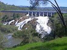 Overflow in April 2006 | |
| Country | United States |
| Location | Calaveras / Tuolumne counties, California |
| Coordinates | 37°52′35″N 120°36′18″W / 37.87639°N 120.60500°WCoordinates: 37°52′35″N 120°36′18″W / 37.87639°N 120.60500°W |
| Opening date | 1958 |
| Dam and spillways | |
| Type of dam | Concrete gravity |
| Impounds | Stanislaus River |
| Height | 205 ft (62 m) |
| Length | 1,914 ft (583 m) |
| Reservoir | |
| Creates | Tulloch Reservoir |
| Total capacity | 68,400 acre⋅ft (84,400,000 m3) |
| Active capacity | 67,000 acre⋅ft (83,000,000 m3) |
| Catchment area | 980 sq mi (2,500 km2) |
| Surface area | 1,280 acres (520 ha) |
| Normal elevation | 510 ft (160 m) |
| Power Station | |
| Turbines | 2x vertical Francis |
| Installed capacity | 18 MW |
| Annual generation | 93 million KWh |
Tulloch Dam is a hydroelectric dam on the Stanislaus River in central California. The dam is part of the Stanislaus River Tri-Dam project cooperatively owned by the Oakdale and South San Joaquin Irrigation Districts, and was completed in 1958. It serves mainly for irrigation purposes but also has a power station with a capacity of 18 megawatts.[1] The dam is located just downstream of the New Melones Dam and upstream of the Goodwin Dam.
See also
References
- ↑ "Project Summary - Donnells & Beardsley". Energy NewsData. Retrieved 2011-10-23.
This article is issued from
Wikipedia.
The text is licensed under Creative Commons - Attribution - Sharealike.
Additional terms may apply for the media files.