Thuli River
| Thuli River | |
|---|---|
 | |
| Country | Zimbabwe |
| Physical characteristics | |
| Main source | Matopo Mission, Matobo District, Zimbabwe |
| River mouth | Shashe River |
| Discharge |
|
| Basin features | |
| Basin size | 7,910 km2 (3,050 sq mi) |
The Thuli River, former name Tuli River, is a major tributary of the Shashe River in Zimbabwe. It rises near Matopo Mission, Matobo District, and flows into the Shashe River near Tuli village.
Hydrology
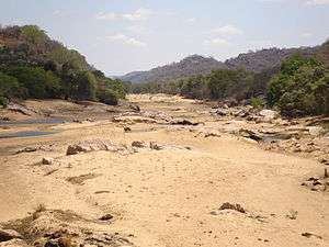
The Thuli is an ephemeral river, with declining annual unit runoff.[2]
Major tributaries of the Thuli River include the Mtshabezi, Mtshelele and Mwewe Rivers.
The Thuli River below Thuli-Makwe Dam is a sand filled channel, with alluvial aquifers in the river channel.[3]
Towns along the river
The Thuli River passes through no major settlements, only the following business centres:
- Freda Mine
- Guyu
- Manama
Bridges and crossings

There are five main bridges over the Mzingwane River:
- Bridge on Old Gwanda Road, between Matombo Mission and Blanket Mine.
- Bridge on Gwanda - Kezi road, below Thuli-Makwe Dam.
- Elliot Bridge, upstream of Guyu.
- Bridge on Manama - Kafusi road.
- Mankonkoni Bridge on Tuli - Kafusi road. This bridge was destroyed by Cyclone Eline.
There are also a number of fords and crossing points, including:
- Ntalale causeway, which was badly damaged by Cyclone Eline.
- Causeway below Thuli gorge
Development
In addition to a number of small weirs, there is one major dam on the Thuli River:
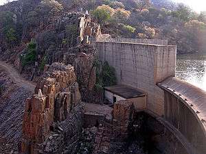
- Thuli–Makwe Dam, west of Gwanda. It is located near the confluence with the Mtshelele River and supplies water for irrigation.
The Mtshabezi River (the principal left-bank tributary) is dammed at Mtshabezi, Sheet and Blanket. Mtshabezi Dam will augment the water supply for the City of Bulawayo, once a connecting pipeline has been completed. Sheet and Blanket Dams supply water to the City of Gwanda and Blanket and Vubachikwe Mines.
Two additional dam sites have been selected further downstream:
- Thuli–Moswa, where no development has taken place.
- Thuli–Manyange, upstream of Elliot Bridge, where construction was briefly started in 2007 but is now halted.[1]
References
| Wikimedia Commons has media related to Thuli River. |
- 1 2 Chibi, T., Kandori, C. and Makone, B.F. 2005. Mzingwane Catchment Outline Plan. Zimbabwe National Water Authority, Bulawayo.
- ↑ Love, D., Uhlenbrook, S., Madamombe, E., Twomlow, S. and van der Zaag, P. 2006. An evaluation of climate and run-off variability and associated livelihood risks in the Mzingwane Catchment, Limpopo Basin, Zimbabwe. Water Institute of Southern Africa Biennial Conference and Exhibition, Durban, South Africa, May 2006.
- ↑ Görgens, A.H.M. and Boroto, R.A. 1997. Limpopo River: flow balance anomalies, surprises and implications for integrated water resources management. In: Proceedings of the 8th South African National Hydrology Symposium, Pretoria, South Africa.