Tule Valley
| Tule Valley | |
| (1859: White Valley) | |
| Endorheic basin | |
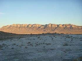 Shadow on the eponymic white rocks of Tule Valley | |
| Country | United States |
|---|---|
| State | Utah |
| County | Millard and extends into Juab County |
| Elevation | 4,780 ft (1,457 m) [1] |
| Lowest point | Tule Spring |
| - elevation | 1,348 m (4,423 ft) [2] |
| Area | 248 sq mi (642 km2) |
| Population | 0 |
| Biome | central Basin & Range ecoregion |
| Geology | down-faulted graben (normal faults), carbonate knolls/horsts, alluvial sediments with marls [3] |
| Period | Silurian-Devonian carbonates Quaternary sediments Pleistocene marls [3] |
| Easiest access | 1 paved road |
| GNIS ID, HUC |
1438072 (1979),[1] 16020303[4] |

Tule Valley, also known as White Valley, is a north-south trending endorheic valley within the Great Basin (geographically), Great Basin Desert (ecologically), and Basin and Range Province (tectonically) of west-central Utah. It is bounded on the west by the Confusion Range, on the east by the House Range, to the north by the Middle Range and the Great Salt Lake Desert, and the south by Wah Wah Valley and the Wah Wah Mountains. The central part of the valley has several knolls, the largest of which is Coyote Knolls. The White Valley name comes from the abundance of white rocks noted by James H. Simpson in 1859.[5] These rocks are mostly Lake Bonneville marls in the valley floor.
Geographic features
Tule Valley's most prominent feature may be Coyote Springs, an important spring system for local wildlife and feral horses which populate the valley. It is also used as a gateway to viewing and traveling toward the base of Notch Peak, a 4,450 foot carbonate rock cliff (2,200 foot of which is pure vertical drop), the tallest carbonate cliff in North America. The name "Tule" is a reference to a swamp plant that probably was found at Coyote Springs during early exploration of the valley.[5]
The valley itself is very isolated, and only has one paved road through its southern end, US Highway 6/US Highway 50. There are no permanent human residents of the valley, though shepherds are known to populate it in the spring. The center of the valley is a large playa, the place where all precipitation from the drainage basin collects, since it is an isolated basin and watershed.[6] This is the location of the lowest point in Millard County, Utah.[7]
Geology
The geology of Tule Valley consists of Quaternary alluvial sediments punctuated by chalky white Pleistocene marls. The valley is a true graben in the sense that it is down-faulted by normal faults on both sides of the valley. The knolls in the valley are horsts of Silurian to Devonian carbonates.[3]
Tule Valley watershed
The Tule Valley hydrologic unit is an area of several Utah valleys and ridgelines of the Basin and Range Province.[8] The endorheic watershed's volume of surface water averages 4,000 acre feet (4,900,000 m3).[9]
References
| Wikimedia Commons has media related to Tule Valley. |
- 1 2 U.S. Geological Survey Geographic Names Information System: Tule Valley (1438072), Tule Valley Hardpan (1437736), Coyote Knolls (1427049) (search)
- ↑ Schneider, Bill and Ann Seifert, Hiking Utah, Falcon, 2005, p. 102 ISBN 978-0-7627-2566-3
- 1 2 3 Chronic, Halka (1990). Roadside Geology of Utah. p. tbd. ISBN 0-87842-228-5.
- ↑ "Tule Valley Watershed -- 16020303". Surf Your Watershed. Environmental Protection Agency. Retrieved 2010-05-07. External link in
|work=(help) - 1 2 Van Cott, J. W., 1990, Utah Place Names, ISBN 0-87480-345-4
- ↑ http://cfpub.epa.gov/surf/huc.cfm?huc_code=16020303
- ↑ Nash, Fred J., 2008, Utah's Low Points: A guide to the Lowest Points in Utah's 29 Counties, pg. 114-122, ISBN 978-0-87480-932-9
- ↑ Davis, Fitzhugh D (2005). "Water Resources of Millard County, Utah" (PDF). Utah Geological Survey. p. 12. Retrieved 2010-05-09.
- ↑ "West Desert Basin" (PDF). Utah State Water Plan. Retrieved 2010-05-06.
Places adjacent to Tule Valley | ||||||||||
|---|---|---|---|---|---|---|---|---|---|---|
| ||||||||||
Gallery
|
|

Coordinates: 38°57′25″N 113°22′34″W / 38.9568985°N 113.376079°W