Troussures
| Troussures | |
|---|---|
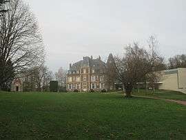 View of Château of Troussures. | |
 Troussures Location within Hauts-de-France region  Troussures | |
| Coordinates: 49°23′24″N 1°58′25″E / 49.39°N 1.9736°ECoordinates: 49°23′24″N 1°58′25″E / 49.39°N 1.9736°E | |
| Country | France |
| Region | Hauts-de-France |
| Department | Oise |
| Arrondissement | Beauvais |
| Canton | Beauvais-2 |
| Area1 | 5.18 km2 (2.00 sq mi) |
| Population (2012)2 | 182 |
| • Density | 35/km2 (91/sq mi) |
| Time zone | UTC+1 (CET) |
| • Summer (DST) | UTC+2 (CEST) |
| INSEE/Postal code | 60649 /60390 |
| Elevation |
97–231 m (318–758 ft) (avg. 130 m or 430 ft) |
|
1 French Land Register data, which excludes lakes, ponds, glaciers > 1 km2 (0.386 sq mi or 247 acres) and river estuaries. 2 Population without double counting: residents of multiple communes (e.g., students and military personnel) only counted once. | |
Troussures is a former commune in the Oise department in northern France. On 1 January 2017, it was merged into the commune Auneuil.[1] The château of Troussures shelters a priory of Community of St. John who organizes sessions and spiritual retreats.
See also
References
- ↑ Arrêté préfectoral 30 December 2016 (in French)
| Wikimedia Commons has media related to Troussures. |
This article is issued from
Wikipedia.
The text is licensed under Creative Commons - Attribution - Sharealike.
Additional terms may apply for the media files.