Tropical Storm Gladys (1991)
| Severe tropical storm (JMA scale) | |
|---|---|
| Category 1 typhoon (SSHWS) | |
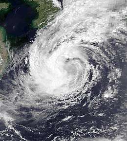 Tropical Storm Gladys early on August 21 | |
| Formed | August 15, 1991 |
| Dissipated | August 24, 1991 |
| Highest winds |
10-minute sustained: 110 km/h (70 mph) 1-minute sustained: 120 km/h (75 mph) |
| Lowest pressure | 965 hPa (mbar); 28.5 inHg |
| Fatalities | 113 total |
| Damage | $252.8 million (1991 USD) |
| Areas affected | Japan, South Korea |
| Part of the 1991 Pacific typhoon season | |
Tropical Storm Gladys in August 1991 was a large tropical cyclone that affected Japan and South Korea. An area of disturbed weather within the Western Pacific monsoon trough on August 15. Slowly organizing, the disturbance developed into a tropical depression on August 15. Heading northwest, Gladys became a tropical storm the following day. Despite forecasts calling for significant strengthening, only slow intensification occurred thereafter due to the storm's large size. After turning west, Gladys attained peak intensity on August 21 near Okinawa. After turning north and bypassing Kyushu, Gladys began to encounter significant wind shear, which caused weakening. Gladys veered west, interacting with land. Gladys weakened to a tropical depression on August 24, and dissipated the next day.
Affecting the Philippines weeks after a volcanic eruption, the storm forced 67,000 people to evacuate but there were no deaths. Across southern Japan, the storm dropped heavy rains, with rainfall totals in some areas exceeding 710 mm (28 in). Overall, 23 fatalities were reported and 11 others sustained injuries. Nearly 200,000 train passengers were stranded. A total 53 houses were destroyed while 4,162 others were flooded. According to the National Police Agency, torrential rains caused 92 landslides, damaged 48 roads, and washed away four bridges. Four ships as well as 4,142 ha (10,235 acres) of farmland were damaged. Monetary damage totaled 11.9 billion yen ($88.4 million USD). The storm's unusually large wind field resulted in extremely heavy precipitation across South Korea, where at least 90 people were killed while 62 others were injured. About 6,700 houses were flooded and over 1,500 houses were damaged, which resulted in 40,000 homeless. Over 100 ha (245 acres) of farmland were inundated. Damage there was estimated at $164 million USD.
Meteorological history
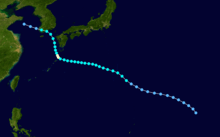
The origins of Gladys can be traced back to an active Western Pacific monsoon trough during mid-August 1991. An area of disturbed weather developed within the trough late on August 13. A weak low-pressure area then developed and over the next two days, the disturbance slowly organized[1] while tracking northwestward.[2] The JMA upgraded the disturbance into a tropical depression at 00:00 UTC on August 15 while the JTWC issued a Tropical Cyclone Formation Alert (TCFA) at 07:30 UTC.[3][nb 1] An increase in curved banding features prompted the JTWC to declare the system Tropical Depression 14W at 00:00 UTC on August 16.[2] At the same time, the JMA upgraded the depression into a tropical storm,[5][nb 2] with the JTWC following suit that evening.[7]
Initially, Gladys was forecast by the JTWC to intensify considerably, with one advisory predicting the system to attain winds of 225 km/h (140 mph), just below super typhoon intensity, and through August 18, the JTWC forecast the storm to attain winds of at least 185 km/h (115 mph). However, Gladys' large size prevented significant organization, with tropical storm force winds extending some 665 km (415 mi) from the center.[1] On August 17, the JMA upgraded Gladys into a severe tropical storm.[3] Continuing to slowly intensify,[5] Gladys turned west,[2] contrast to forecasts of recurvature,[1] tracking through the Ryukyu Islands.[2] On August 18, the JMA estimated that the storm attained its peak velocity of 115 km/h (70 mph), which it would maintain for several days.[3] Surface observations from the Amami Ōshima prompted the JTWC to upgrade Gladys to a typhoon early on August 21 165 km (105 mi) northeast of Okinawa. At this time, the JTWC estimated peak intensity of 120 km/h (75 mph)[1] while the JMA estimated a minimum barometric pressure of 965 mbar (28.5 inHg).[3] The same day, the storm turned north, passing west of Kyushu before turning northwest east of the Korean Peninsula under the influence of a ridge over the Sea of Japan.[1][2] A passing trough to its north enhanced southerly wind shear, and that along with land interaction triggered rapid weakening. The JTWC discontinued warnings at noon on August 23,[1] with the JMA classifying Gladys as a tropical depression the next day. The JMA ceased tracking the storm altogether on August 25.[3]
Impact
Philippines
Monsoon rains caused by Gladys prompted maximum weather alerts for nine major river valleys in the provinces of Tarlac, Pampanga, and Zambales, all previously affected by a volcanic eruption weeks earlier. In the later, 15,000 people were evacuated from six villages while 52,000 others were evacuated from nine cities in Pampanga. Many areas, including Manila, sustained flooding, but no fatalities were reported.[8]
Japan
Due to its large wind field,[2] the storm dropped heavy rainfall across much of the Japanese archipelago for several days. The heaviest rainfall occurring near Kyusyu,[9] with many locations receiving over 710 mm (28 in) of rainfall.[1] A peak rainfall total occurred of 848 mm (33.4 in) at Hidegadake.[10] A peak hourly rainfall total of 45 mm (1.8 in) was observed in Naze.[11] Meanwhile, a peak daily precipitation total of 415 mm (16.3 in) fell in Koinya.[12] A wind gust of 76 km/h (47 mph) was recorded on Nomozaki.[13]
While passing south of Okinawa, the outer fringes of the storm dropped moderate to heavy rainfall across Tokushima Prefecture. Roads were cut in 15 places and damage there amounted to 160 million yen.[14] On the southern tip of Kyushu Island, two people suffered injuries in Kagoshima Prefecture. A total of 168 homes were damaged and 12 others were destroyed.[15] Twenty-nine homes were damaged and four were demolished, resulting in six people homeless.[16] Throughout Kanagawa Prefecture, sxity-two homes wrre damaged and three more were destroyed. A total of 35,000 households were left without power. In Hakone, one person died after he fell from his automobile. There, 24 roads necessitated closure. Across Hakone and Odawara, 13 mudslides were reported.[17] Throughout Tokyo, one person was wounded. A total of nineteen homes were damaged and five were destroyed. Roads were flooded in 37 districts across the city.[18] Five people died and three were reported missing in Okutama after a mudslide buried two wooden houses and a hotel.[19][18] A fire killed three people, left another missing, and injured two others in Izu.[20] Six ferries were delayed offshore Chiba Prefecture.[21] Seven people were killed in Otsuki, two in traffic accidents and five motorists died when a landslide swept their vehicles off a highway.[19] In Ibaraki Prefecture, eighteen homes were damaged and one was destroyed.[22] Further north, in Saitama Prefecture, 1,495 homes were damaged and 224 others were destroyed, resulting in 668 homeless. A total of 1,281 ha (3,170 acres) of arable land was flooded. One person was also injured.[23] Damage in Gunma prefecture amounted to $3.8 billion yen,[24] where 97 roads were destroyed and 38 rivers flooded.[25] Thirty-nine landslides occurred in Tochigi Prefecture. A total of 658 homes were damaged and 76 others were destroyed. Embankments were damaged in 45 locations. Damage there was estimated at 14.3 billion yen.[26] Fifty homes sustained damage in Fukushima Prefecture.[27]
Nationwide, 23 fatalities were reported and 11 others sustained injuries.[9][19] Nearly 200,000 train passengers were stranded.[19] A total 53 houses were destroyed while 4,162 others were flooded.[9] According to the National Police Agency, torrential rains caused 92 landslides, cut 48 roads and washed away four bridges.[28] Four ships as well as 4,142 ha (10,235 acres) of farmland were damaged.[9] Monetary damage totaled 11.9 billion yen $$88.4 million USD.[9][nb 3][nb 4]
South Korea
In advance of the storm, 22,000 tourists were evacuated from low-lying areas while 44,000 ships were pulled into shelter.[29] Typhoon warnings were issued for the Cheju area. According to authorities, the primary threat of the cyclone was expected to be heavy rainfall.[30] Tropical Storm Gladys' broad circulation caused torrential rainfall in South Korea; Pusan, South Korea’s second largest city, received 610 mm (24 in) of rain in 20 hours, setting a single-day rainfall record. Furthermore, sections along the southeast coast were reported to have received 660 mm (26 in) during the same period.[2] During a 24-hour period in Ulsan, 420 mm (16.4 in) of rain fell, the most ever recorded on record.[31] During a two day period, Kyongju received 710 mm (28 in), the heaviest recorded during a storm there since record keeping began in 1904.[32]
In Punsan, eight people were confirmed killed and one was rendered missing, with a man dying after he was struck by a falling steel ladder while the remainder drowned in waist-high floodwaters. The primary highway connecting Seoul to Pusan was blocked by a landslide. Just north off Pulsan, the storm's high winds forced a 950,000 kW (1,273,970 hp) nuclear reactor to shut down. In Ulsan, an industrial city 29 km (18 mi) northeast of Pusan, flooding caused many major automobile plants,[33] including 30 Hyundai plants,[34] to halt operations.[33] More than 500 individuals lost their homes.[34] A man was electrocuted in the city when he stepped on a high-voltage power line knocked by the storm. Further west, five people were killed when their homes were buried in landslides in Changwon. Two people drowned in overflowed rivers in nearby Masan.[33] Throughout South Korea, at least 90 people were killed and 62 others were injured.[1] Telephone lines were cut and rail traffic was disrupted. All domestic flights were cancelled but international flights were not.[33] About 6,700 houses were flooded and over 1,500 houses were damaged, resulting in 40,000 homeless. Over 100 ha (245 acres) of farmland were inundated. Damage was estimated at $146 million USD,[1] with property damage exceeding $44 million.[35]
See also
Notes
- ↑ The Japan Meteorological Agency is the official Regional Specialized Meteorological Center for the western Pacific Ocean.[4]
- ↑ Wind estimates from the JMA and most other basins throughout the world are sustained over 10 minutes, while estimates from the United States-based Joint Typhoon Warning Center are sustained over 1 minute. 10‑minute winds are about 1.14 times the amount of 1‑minute winds.[6]
- ↑ All currencies are converted from Japanese yen to United States Dollars using this with an exchange rate of the year 1991.
- ↑ All damage totals are in 1990 values of their respective currencies.
References
- 1 2 3 4 5 6 7 8 9 Joint Typhoon Warning Center; Naval Pacific Meteorology and Oceanography Center (1992). Annual Tropical Cyclone Report: 1991 (PDF) (Report). United States Navy, United States Air Force. p. 84-87. Retrieved July 22, 2017.
- 1 2 3 4 5 6 7 Hong Kong Observatory (1992). "Part III – Tropical Cyclone Summaries". Meteorological Results: 1991 (PDF). Meteorological Results (Report). Hong Kong Observatory. p. 15. Retrieved July 22, 2017.
- 1 2 3 4 5 Japan Meteorological Agency (October 10, 1992). RSMC Best Track Data – 1990–1999 (.TXT) (Report). Retrieved July 22, 2017.
- ↑ "Annual Report on Activities of the RSMC Tokyo – Typhoon Center 2000" (PDF). Japan Meteorological Agency. February 2001. p. 3. Retrieved July 22, 2017.
- 1 2 Kenneth R. Knapp; Michael C. Kruk; David H. Levinson; Howard J. Diamond; Charles J. Neumann (2010). 1991 GLADYS (1991226N18159). The International Best Track Archive for Climate Stewardship (IBTrACS): Unifying tropical cyclone best track data (Report). Bulletin of the American Meteorological Society. Retrieved July 22, 2017.
- ↑ Christopher W Landsea; Hurricane Research Division (April 26, 2004). "Subject: D4) What does "maximum sustained wind" mean? How does it relate to gusts in tropical cyclones?". Frequently Asked Questions:. National Oceanic and Atmospheric Administration's Atlantic Oceanographic and Meteorological Laboratory. Retrieved July 22, 2017.
- ↑ Tropical Storm 14W Best Track (TXT) (Report). Joint Typhoon Warning Center. December 17, 2002. Retrieved July 22, 2017.
- ↑ "Over 65,000 Flee Homes Because of Flooding Around Volcano". Associated Press. August 20, 1991.
- 1 2 3 4 5 Asanobu, Kitamoto. Typhoon 199112 (Gladys). Digital Typhoon (Report). National Institute of Informatics. Retrieved July 22, 2017.
- ↑ Asanobu, Kitamoto. AMeDAS HIDEGADAKE (64211) @ Typhoon 199112. Digital Typhoon (Report). National Institute of Informatics. Retrieved July 22, 2017.
- ↑ Asanobu, Kitamoto. AMeDAS NAZE (88836) @ Typhoon 199112. Digital Typhoon (Report). National Institute of Informatics. Retrieved July 22, 2017.
- ↑ Asanobu, Kitamoto. AMeDAS KONIYA (88901) @ Typhoon 199112. Digital Typhoon (Report). National Institute of Informatics. Retrieved July 22, 2017.
- ↑ Asanobu, Kitamoto. AMeDAS NOMOZAKI (84596) @ Typhoon 199112. Digital Typhoon (Report). National Institute of Informatics. Retrieved July 22, 2017.
- ↑ Asanobu, Kitamoto. 1991-895-11. Digital Typhoon (Report). National Institute of Informatics. Retrieved July 25, 2017.
- ↑ Asanobu, Kitamoto. 1991-827-11. Digital Typhoon (Report). National Institute of Informatics. Retrieved July 25, 2017.
- ↑ Asanobu, Kitamoto. 1991-817-14. Digital Typhoon (Report). National Institute of Informatics. Retrieved July 25, 2017.
- ↑ Asanobu, Kitamoto. 1991-670-02. Digital Typhoon (Report). National Institute of Informatics. Retrieved July 25, 2017.
- 1 2 Asanobu, Kitamoto. 1991-662-06. Digital Typhoon (Report). National Institute of Informatics. Retrieved July 25, 2017.
- 1 2 3 4 "At Least 9 Dead, Over 1,800 Homes Flooded in Torrential Rains". Associated Press. August 21, 1991.
- ↑ Asanobu, Kitamoto. 1991-656-04. Digital Typhoon (Report). National Institute of Informatics. Retrieved July 25, 2017.
- ↑ Asanobu, Kitamoto. 1991-648-13. Digital Typhoon (Report). National Institute of Informatics. Retrieved July 25, 2017.
- ↑ Asanobu, Kitamoto. 1991-629-09. Digital Typhoon (Report). National Institute of Informatics. Retrieved July 25, 2017.
- ↑ Asanobu, Kitamoto. 1991-626-06. Digital Typhoon (Report). National Institute of Informatics. Retrieved July 25, 2017.
- ↑ Asanobu, Kitamoto. 1991-624-16. Digital Typhoon (Report). National Institute of Informatics. Retrieved July 25, 2017.
- ↑ Asanobu, Kitamoto. 1991-624-12. Digital Typhoon (Report). National Institute of Informatics. Retrieved July 25, 2017.
- ↑ Asanobu, Kitamoto. 1991-615-03. Digital Typhoon (Report). National Institute of Informatics. Retrieved July 25, 2017.
- ↑ Asanobu, Kitamoto. 1991-595-05. Digital Typhoon (Report). National Institute of Informatics. Retrieved July 25, 2017.
- ↑ "Typhoon kills 11 in Japan". Agence France Presse. August 22, 1991.
- ↑ "Typhoon Gladys Hits Korean Coast, Weakens; 15 Dead, Thousands Evacuated". Associated Press. August 23, 1991.
- ↑ "Typhoon Gladys veers west and heads for Korea". Agence France Presse. August 23, 1981.
- ↑ "At Least 60 Dead, Dozens Missing as Typhoon Lashes South Korea". Associated Press. August 24, 1991.
- ↑ "Typhoon leaves trail of destruction". United Press International. August 24, 1991.
- 1 2 3 4 "Typhoon Spawns Heavy Downpours, 42 Koreans Dead or Missing". Associated Press. August 23, 1991.
- 1 2 "typhoon hits south Xkorea". Xinhua General News Service. August 23, 1991.
- ↑ "Typhoon leaves nearly 11,000 homeless". United Press International. August 25, 1991.