Triple Divide Peak (Madera County, California)
| Triple Divide Peak | |
|---|---|
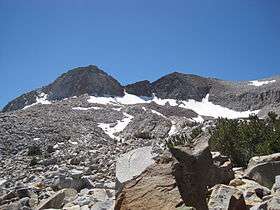 Triple Divide Peak from the north | |
| Highest point | |
| Elevation | 11,616 ft (3,541 m) NAVD 88[1] |
| Prominence | 651 ft (198 m) [1] |
| Coordinates | 37°37′55″N 119°22′14″W / 37.6318783°N 119.3704219°WCoordinates: 37°37′55″N 119°22′14″W / 37.6318783°N 119.3704219°W [2] |
| Geography | |
 Triple Divide Peak  Triple Divide Peak | |
| Location | Madera County, California U.S. |
| Parent range | Sierra Nevada |
| Topo map | USGS Mount Lyell |
| Climbing | |
| First ascent | 1920 by Norman Clyde[3] |
| Easiest route | Scramble, class 3[3] |
Triple Divide Peak is a mountain on the boundary between Yosemite National Park and the Ansel Adams Wilderness in Madera County, California. It is located 0.7 miles (1.1 km) north of Walton Lake and 1.3 miles (2.1 km) southeast of Merced Peak. Its name refers to the fact that it lies on the boundaries of three distinct watersheds, namely those of the Merced, South Fork Merced, and San Joaquin rivers.
References
- 1 2 "Triple Divide Peak, California". Peakbagger.com.
- ↑ "Triple Divide Peak". Geographic Names Information System. United States Geological Survey.
- 1 2 Secor, R.J. (2009). The High Sierra Peaks, Passes, and Trails (3rd ed.). Seattle: The Mountaineers. p. 408. ISBN 9780898869712.
This article is issued from
Wikipedia.
The text is licensed under Creative Commons - Attribution - Sharealike.
Additional terms may apply for the media files.