Trinity, Edinburgh
Trinity
| |
|---|---|
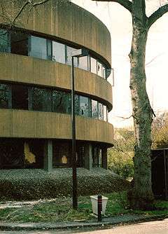 Trinity Park House, now demolished | |
| Council area | |
| Country | Scotland |
| Sovereign state | United Kingdom |
| Postcode district | EH |
| Dialling code | 0131 |
| Police | Scottish |
| Fire | Scottish |
| Ambulance | Scottish |
| EU Parliament | Scotland |
Trinity is a district of northern Edinburgh, Scotland, once a part of Greater Leith (itself a part of the city since 1920). It is one of the more desirable neighbourhoods of Edinburgh. It is bordered by Wardie to the west and north-west, Newhaven to the north-east, Victoria Park to the east and Bangholm to the south.
Origin

The name derives from Trinity House in Leith, which formerly held these lands and had a large estate farm, Trinity Mains, in the area. The coat of arms from the farm is preserved on the gable of a modern block on Newhaven Main Street.
Although having some buildings from the 18th century, the area was largely developed in the early 19th century, as a mansion house district, broadly comparable in style to The Grange area of Edinburgh (Trinity is sometimes referred to as Leith's Grange). Many buildings were "second homes" to rich families in the New Town and were treated as a "country retreat".
The style of housing is now very mixed, as the area has always been seen as desirable, and developers have accordingly been keen to build, usually in the preferred architectural style of their period. Victoria Park adds to the area's amenities as do a large number of cycle paths and walkways derived from the city's disused northern suburban railway lines. East Trinity Road is typical in having property types ranging from original mansions, Victorian terraces and tenements, cottages to modern developments. Craighall Crescent has a Victorian crescent on one side of the street with much later houses on the other side.
Buildings of interest
The remnant northeast wing of the 15th century Wardie Castle (later Wardie House) survives on Wardie House Lane. This was rebuilt in 1780 by Sir Alexander Boswall who gives his name to Boswall Road.
Numbers 17 to 23 Boswall Road were built in 1815 by Donald Pollock, Chancellor of the University of Edinburgh. The westmost wing (containing a telescope viewing area to the harbour) was his own house. The central and east blocks were built as the Pollock Missionary School. The doorpiece on number 21 seems a later addition to embellish this otherwise plainer block.
The most notable building on Boswall Road was Wardie Lodge, later renamed Challenger Lodge by Sir John Murray in 1914, after his Challenger Expedition investigating abyssal lifeforms in the deep oceans. After use as a children's home, it was converted to St Columba's Hospice, providing care for the terminally ill, in 1977.[1] Although still extant, the original lodge is now subsumed by modern buildings for the hospice.
11 Boswall Road, East Cottage, dates from the 17th century and was a part-time summer home for Professor John Wilson pen-named "Christopher North".
From 1821 to 1898 the Trinity Chain Pier was used by ferries and latterly swimmers. The booking office survives as a pub. Trinity Railway Station still survives, up a lane opposite, but is converted to residential use.
Wardie Parish Church is one of several Church of Scotland churches in Trinity.
Trinity Academy is one of the historic schools of the city.
Trinity Park House, an unusual low-rise office block built on the site of the former Trinity Cottage (demolished in 1969)[2] for the National Health Service (NHS) in the 1970s, was demolished between 2006 and 2008 and is to be replaced with a development of apartments, retaining the walled garden.[3] The office, set in 26,480 m² of grounds, attracted controversy, being of a modern style unlike anything in its surroundings, but having mature trees on its grounds and using gentle curves and a muted gold colour-scheme. The proposed replacement housing development attracted its own controversy because of its scale and proposed style.[4] Although many of the mature trees on the site were cut down to allow a larger building footprint for the new development, a rare Strawberry tree was relocated on-site.[5] The original development stalled and was later abandoned in the wake of the Financial crisis of 2007–2010 and by April 2010 all construction equipment had been removed from the site. In 2011, development of a new, more mixed development is now underway. The NHS department has relocated to the edge of the city at South Gyle.
Notable residents
- Allan Ker VC (1883-1958) lived at St Abbs on Russell Place
- James McBain FRSE (1807-1879) Royal Navy surgeon and naturalist, lived his final years in Trinity and died at Logie Villa on York Road[6]
- Dr James Russell FRSE (1754-1836) lived at Bangholm Bower House.
See also
- The city's Trinity House Maritime Museum, run by Historic Environment Scotland, is not in the Trinity area and should not be confused with Trinity Park House.
References
- ↑ St Columba's Hospice: http://www.stcolumbashospice.org.uk/index.php?option=com_content&view=article&id=3&Itemid=73
- ↑ PDF document covering the history of the Scottish NHS Information Services Department
- ↑ Trinity Gardens website
- ↑ Edinburgh Evening News newspaper story
- ↑ Scotsman newspaper story
- ↑ Biographical Index of Former Fellows of the Royal Society of Edinburgh 1783–2002 (PDF). The Royal Society of Edinburgh. July 2006. ISBN 0 902 198 84 X.
External links
Coordinates: 55°58′38.92″N 3°12′9.01″W / 55.9774778°N 3.2025028°W