Triesenberg
| Triesenberg | |||
|---|---|---|---|
| Municipality | |||
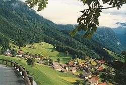 Triesenberg in late-August 1987 | |||
| |||
 Triesenberg and its exclave in Liechtenstein | |||
| Coordinates: 47°7′5″N 9°32′36″E / 47.11806°N 9.54333°ECoordinates: 47°7′5″N 9°32′36″E / 47.11806°N 9.54333°E | |||
| Country |
| ||
| Electoral district | Oberland | ||
| Villages | Gaflei, Malbun, Masescha, Rotenboden, Silum, Steg, Sücka, Wangerberg | ||
| Area | |||
| • Total | 29.8 km2 (11.5 sq mi) | ||
| Elevation | 884 m (2,900 ft) | ||
| Population [1] | |||
| • Total | 2,618 | ||
| Time zone | UTC+1 (CET) | ||
| • Summer (DST) | CEST | ||
| Postal code | 9497 | ||
| Area code(s) | 7004 | ||
| ISO 3166 code | LI-10 | ||
| Website | www.triesenberg.li | ||

Triesenberg is a municipality in Liechtenstein with a population of 2,618. Its area of 30 square kilometers makes it the largest municipality in Liechtenstein. The center of the municipality rests at an elevation of 884 – 1,000 metres.
History
Triesenberg is noted for its distinct dialect, dating from the influence of Walser migrants in the Middle Ages, who arrived in the region early in the 14th century.[2] This dialect is actively promoted by the municipality. The existence of this dialect is one evidence of remarkable linguistic diversity within the small Principality, as it is spoken alongside the Standard German and Alemannic dialect common to the country.
Geography
The municipality includes 8 villages: Gaflei, Malbun, Masescha, Rotenboden, Silum, Steg, Sücka and Wangerberg. Malbun is the only ski-resort village in the country, located not far from the Austrian border.
Notable people
- Gustav Schädler (1883 Triesenberg – 1961 in Vaduz), politician and a former Prime Minister of Liechtenstein
- Marco Schädler (born 1964 in Triesenberg) composer, he studied music at the conservatory in Feldkirch, Austria.
Gallery
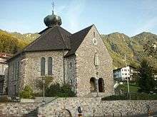 St. Joseph's Parish Church
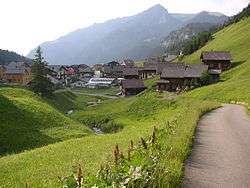 The village of Malbun
References
- ↑ https://www.llv.li/files/as/bevolkerungsstatistik-30-juni-2017.pdf
- ↑ P. Christiaan Klieger, The Microstates of Europe: Designer Nations in a Post-Modern World (2014), p. 41
External links
![]()