Ruggell
| Ruggell | |||
|---|---|---|---|
| Municipality | |||
 | |||
| |||
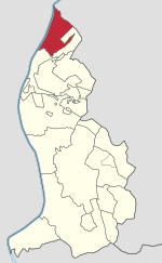 Ruggell in Liechtenstein | |||
| Coordinates: 47°14′36″N 9°31′48″E / 47.24333°N 9.53000°ECoordinates: 47°14′36″N 9°31′48″E / 47.24333°N 9.53000°E | |||
| Country |
| ||
| Electoral district | Unterland | ||
| Villages | none | ||
| Area | |||
| • Total | 7.38 km2 (2.85 sq mi) | ||
| Elevation | 433 m (1,421 ft) | ||
| Population (30-06-2017)[1] | |||
| • Total | 2,243 | ||
| Time zone | UTC+1 (CET) | ||
| • Summer (DST) | CEST | ||
| Postal code | 9491 | ||
| Area code(s) | 7010 | ||
| ISO 3166 code | LI-06 | ||
| Website | www.ruggell.li | ||
Ruggell is the most northerly and low-lying of the Liechtenstein communities/municipalities, with population of 2,243 in 2017.[2]
History
The name is said to be from the Latin for "clearing the land" (roncale - ad roncalem). Most known for conservation areas and the historic St. Fridolin's Parish Church.
Geography
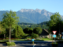
While Liechtenstein is known as a largely mountainous country, Ruggell is largely flat and is situated along the Rhine River, where the international borders with Switzerland and Austria meet.
Notable people
- Benjamin Büchel (born 1989 in Ruggell) international footballer who plays for FC Vaduz.
References
External links
![]()
- Official website (in German)
This article is issued from
Wikipedia.
The text is licensed under Creative Commons - Attribution - Sharealike.
Additional terms may apply for the media files.