Treska
| Treska | |
|---|---|
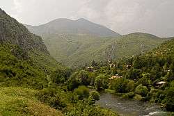 View to the Treska in the Poreče Region | |
| Country | Former Yugoslav Republic of Macedonia |
| Physical characteristics | |
| River mouth |
Vardar 42°00′08″N 21°20′50″E / 42.0022°N 21.3473°ECoordinates: 42°00′08″N 21°20′50″E / 42.0022°N 21.3473°E |
| Basin features | |
| Progression | Vardar→ Aegean Sea |

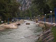
Matka dam
Kayak track in the River
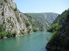
Lake Matka
Treska (Macedonian: Треска) is a river in the western part of the Former Yugoslav Republic of Macedonia, a right tributary to Vardar. It is 132 km (82 mi) long, and its basin is 2350 km².[1]
It rises in the Stogovo mountain at an altitude of around 2000 meters, and flows eastwards through the valley of Kičevo. At Makedonski Brod it turns northwards, flows between the mountains of Suva Gora and Karadžica, finally flowing into the Vardar in the Skopje suburb Gjorče Petrov.
Three dams have been built on Treska:
- in 1937 the Matka dam and lake near Skopje
- in 2004 the Kozjak dam and lake
- in 201? the Sveta Petka
References
- ↑ Opća enciklopedija Jugoslavenskog leksikografskog zavoda - Zagreb, 1982. (2. izdanje)
| Wikimedia Commons has media related to Treska. |
This article is issued from
Wikipedia.
The text is licensed under Creative Commons - Attribution - Sharealike.
Additional terms may apply for the media files.