Trautmannsdorf an der Leitha
| Trautmannsdorf an der Leitha | ||
|---|---|---|
| ||
 Trautmannsdorf an der Leitha Location within Austria | ||
| Coordinates: 48°1′N 16°37′E / 48.017°N 16.617°ECoordinates: 48°1′N 16°37′E / 48.017°N 16.617°E | ||
| Country | Austria | |
| State | Lower Austria | |
| District | Bruck an der Leitha | |
| Government | ||
| • Mayor | Heinz-Christian Berthold | |
| Area | ||
| • Total | 35.39 km2 (13.66 sq mi) | |
| Elevation | 168 m (551 ft) | |
| Population (1 January 2016)[1] | ||
| • Total | 2,815 | |
| • Density | 80/km2 (210/sq mi) | |
| Time zone | UTC+1 (CET) | |
| • Summer (DST) | UTC+2 (CEST) | |
| Postal code | 2454 | |
| Area code | 02169 | |
| Website | www.trautmannsdorf.at | |

Trautmannsdorf an der Leitha is a town in the district of Bruck an der Leitha in Lower Austria in Austria.
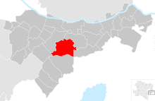
Trautmannsdorf an der Leitha in the district of Bruck an der Leitha
Geography
Trautmannsdorf an der Leitha lies in the industrial area of Lower Austrica. The Leitha River crosses the municipality It is the third-largest municipality of the district. About 9.56 percent of the municipality is forested.
The municipality contains following villages (in brackets are the Population numbers of the 1 January 2017)
- Trautmannsdorf an der Leitha (979)
- Gallbrunn (736)
- Stixneusiedl (580)
- Sarasdorf (568)
References
- ↑ Statistik Austria - Bevölkerung zu Jahresbeginn 2002-2016 nach Gemeinden (Gebietsstand 1.1.2016) for Trautmannsdorf an der Leitha.
This article is issued from
Wikipedia.
The text is licensed under Creative Commons - Attribution - Sharealike.
Additional terms may apply for the media files.