Transmitter Solt
| Transmitter Solt | |
|---|---|
| Solti rádióadó | |
 | |
| General information | |
| Status | In use |
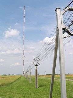
| Type | Mast radiator insulated against ground |
| Location | Solt, Bács-Kiskun, Hungary |
| Construction started | 6 September 1974 |
| Completed | 10 January 1977 |
| Height | 303.6 m |
| Design and construction | |
| Main contractor | Magyar Posta (Hungarian Post) |
The Transmitter Solt (Hungarian: Solti rádióadó) is a radio transmission facility for 540 kHz MW (Medium Wave) near Solt, Hungary, serving as the primary transmitter site for Kossuth Rádió.[1] With an output power of 2000 kW (2 MW), it is the most powerful radio transmitter in Europe and is among the most powerful radio transmitters in the world.[2][3] Its intended broadcast area covers the Hungarian-speaking territories of Central- and Eastern Europe, however successful reception of the Kossuth Rádió was reported from as far as Kazan, Russia (~2,200 km) to the east, Kuala Lumpur[3][4] to the southeast (~13,500 km) and Ireland (~1,900 km) to the west in the evening.[3][5] It uses a 303.6-metre (298.4 m long radiating) guyed mast.[3] The transmitter site (including all the equipment) has been a protected industrial monument since 2013.[6]
Location
Transmitter Solt located in the Great Hungarian Plain, 4 km north from Solt and 80 km south from Budapest.[7]
History
By the 1970s Lakihegy Tower became out-of-date (covered only 50% of the country's territory in 1972) so the Magyar Posta (Hungarian Post) and the central government decided to build a new and much more powerful transmitter. Construction started in 1974 with the cooperation of the Soviet Union as a high priority project. Several farmhouses and barns were demolished around the mast and the area became closed.[1] Europe's most powerful radio transmitter was designed by Hungarian, Polish and Soviet engineers from several companies and organizations, including the Soviet Ministry of Communications (Министерство связи СССР), Hungarian Postal Planning Institute (Postai Tervező Intézet), Power Plant and Network Planning Company (Erőmű és Hálózattervező Vállalat), Road and Rail Planning Company (Út- és Vasúttervező Vállalat) and Budapest Geodesial and Cartographical Company (Budapesti Geodéziai és Térképészeti Vállalat). It was finished in 1977.[3]
The transmitter site underwent a substantial renovation and equipment modernisation in 2017.[8]
Equipment
The original 1977 transmitter was made of two identical, Soviet-made vacuum tube based 1000kW units, whose outputs were combined to produce the required 2000kW output power.[9] It was replaced in 2017 by a solid state Nautel NX2000 consisting of five DRM-enabled NX400 units combined for 2000kW output.[10] The original vacuum tube transmitter (along with the building and radio mast) is a protected industrial monument and remains on site as a backup unit.[11]
See also
References
- 1 2 Fucskó Lajos: A magyar középhullámú műsorszórás (History of the Hungarian medium wave broadcasting, 1924-1975), Híradástechnika, 1975 (Hungarian)
- ↑ List of medium wave transmitters worldwide, MWLIST - longwave, mediumwave, tropical bands and shortwave radio database (English)
- 1 2 3 4 5 Hlatky Béla: Egy évforduló nyomában – 30 éves a solti adó (Solt Transmitter is 30 years old), Híradástechnika, 2008 (Hungarian)
- ↑ http://shortwavedxer.blogspot.com/2012/10/mr1-mr1-kossuth-radio-solt-hungary-on.html
- ↑ Medium wave reception in Kazan, Russia, 540 kHz, Hungary, Kossuth Radio (English)
- ↑ Műemlék lett a solti rádióadó (Transmitter Solt became a monument), Kecskeméti hírhatár (Hungarian)
- ↑ Magyarország autóatlasz, Dimap-Szarvas, Budapest, 2004, ISBN 963-03-7576-1
- ↑ https://www.ahrt.hu/hu/hirek/befejezodtek-a-solti-kozephullamu-radioallomas-rekonstrukcios-munkai
- ↑ http://www.hte.hu/fooldal/-/hir/40-eves-a-solti-radioado-allomas
- ↑ http://www.nautel.com/solutions/digital-radio/2-megawatt-transmitter-antenna-hungaria/
- ↑ http://www.hte.hu/fooldal/-/hir/latogatas-a-solti-kozephullamu-radioallomason-a-media-klub-a-veteltechnikai-es-a-kabeltelevizios-szakosztaly-beszamoloja
- Press photos on the webpage of the operator (Antenna Hungária Zrt.)
- Solt Transmission Mast at Structurae
- Solt Transmission Mast, skyscraperpage.com
Coordinates: 46°50′3.51″N 19°1′53.64″E / 46.8343083°N 19.0315667°E