Tram route 4 (Antwerp)
| Tram route 4 | ||||||||||||||||||||||||||||||||||||||||||||||||||||||||||||||||||||||||||||||||||||||||||||||||||||||||||||||||||||||||||||||||||||||||||||||||||||||||||||||||||||||||||||||||||||||||||||||||||||||||
|---|---|---|---|---|---|---|---|---|---|---|---|---|---|---|---|---|---|---|---|---|---|---|---|---|---|---|---|---|---|---|---|---|---|---|---|---|---|---|---|---|---|---|---|---|---|---|---|---|---|---|---|---|---|---|---|---|---|---|---|---|---|---|---|---|---|---|---|---|---|---|---|---|---|---|---|---|---|---|---|---|---|---|---|---|---|---|---|---|---|---|---|---|---|---|---|---|---|---|---|---|---|---|---|---|---|---|---|---|---|---|---|---|---|---|---|---|---|---|---|---|---|---|---|---|---|---|---|---|---|---|---|---|---|---|---|---|---|---|---|---|---|---|---|---|---|---|---|---|---|---|---|---|---|---|---|---|---|---|---|---|---|---|---|---|---|---|---|---|---|---|---|---|---|---|---|---|---|---|---|---|---|---|---|---|---|---|---|---|---|---|---|---|---|---|---|---|---|---|---|---|
 Itinerary of tram route 4 | ||||||||||||||||||||||||||||||||||||||||||||||||||||||||||||||||||||||||||||||||||||||||||||||||||||||||||||||||||||||||||||||||||||||||||||||||||||||||||||||||||||||||||||||||||||||||||||||||||||||||
| Overview | ||||||||||||||||||||||||||||||||||||||||||||||||||||||||||||||||||||||||||||||||||||||||||||||||||||||||||||||||||||||||||||||||||||||||||||||||||||||||||||||||||||||||||||||||||||||||||||||||||||||||
| Type | tram | |||||||||||||||||||||||||||||||||||||||||||||||||||||||||||||||||||||||||||||||||||||||||||||||||||||||||||||||||||||||||||||||||||||||||||||||||||||||||||||||||||||||||||||||||||||||||||||||||||||||
| System | Antwerp tram network | |||||||||||||||||||||||||||||||||||||||||||||||||||||||||||||||||||||||||||||||||||||||||||||||||||||||||||||||||||||||||||||||||||||||||||||||||||||||||||||||||||||||||||||||||||||||||||||||||||||||
| Locale | Antwerp | |||||||||||||||||||||||||||||||||||||||||||||||||||||||||||||||||||||||||||||||||||||||||||||||||||||||||||||||||||||||||||||||||||||||||||||||||||||||||||||||||||||||||||||||||||||||||||||||||||||||
| Termini |
Deurne Silsburg Hoboken Kioskplaats | |||||||||||||||||||||||||||||||||||||||||||||||||||||||||||||||||||||||||||||||||||||||||||||||||||||||||||||||||||||||||||||||||||||||||||||||||||||||||||||||||||||||||||||||||||||||||||||||||||||||
| Stations | 40 | |||||||||||||||||||||||||||||||||||||||||||||||||||||||||||||||||||||||||||||||||||||||||||||||||||||||||||||||||||||||||||||||||||||||||||||||||||||||||||||||||||||||||||||||||||||||||||||||||||||||
| Color on map | black text on light blue background | |||||||||||||||||||||||||||||||||||||||||||||||||||||||||||||||||||||||||||||||||||||||||||||||||||||||||||||||||||||||||||||||||||||||||||||||||||||||||||||||||||||||||||||||||||||||||||||||||||||||
| Operation | ||||||||||||||||||||||||||||||||||||||||||||||||||||||||||||||||||||||||||||||||||||||||||||||||||||||||||||||||||||||||||||||||||||||||||||||||||||||||||||||||||||||||||||||||||||||||||||||||||||||||
| Operator(s) | De Lijn | |||||||||||||||||||||||||||||||||||||||||||||||||||||||||||||||||||||||||||||||||||||||||||||||||||||||||||||||||||||||||||||||||||||||||||||||||||||||||||||||||||||||||||||||||||||||||||||||||||||||
| Rolling stock | PCC (single and coupled), HermeLijn, five segment Albatros | |||||||||||||||||||||||||||||||||||||||||||||||||||||||||||||||||||||||||||||||||||||||||||||||||||||||||||||||||||||||||||||||||||||||||||||||||||||||||||||||||||||||||||||||||||||||||||||||||||||||
| ||||||||||||||||||||||||||||||||||||||||||||||||||||||||||||||||||||||||||||||||||||||||||||||||||||||||||||||||||||||||||||||||||||||||||||||||||||||||||||||||||||||||||||||||||||||||||||||||||||||||
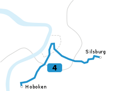
Tram route 4 is an above ground tram route in the city of Antwerp, Belgium. The route runs between the Kioskplaats in the suburb of Hoboken in the South, and the Silsburg cemetery on the Deurne/Wommelgem border in the East.[1] The present day itinerary is the result of the merger of the trajectory from the historic route 8 and that from the original route 4 in 2012.
History
Route 4 is one of the oldest tram routes in the city of Antwerp. It was originally built as a part of a vicinal tramway to Schelle and Boom, but was eventually shortened to the itinerary Groenplaats-Hoboken after the opening of railway line 52 In 1936, it was merged with route 3 into an itinerary Merksem-Central station-Groenplaats-South Station-Hoboken, because too many tram routes had their terminus at the Groenplaats at the time, leading to a chaotic situation. [2]After the end of the Second World War, the route again became a separate line. In 1993, it was extended from the Groenplaats to the Sint-Pietersvliet to the North.[3]
Due to construction works in the Nationalestraat, the route was shortened to the Hoboken-Marnixplaats trajectory on May 2, 2012. After a redrawing of the network map, route 4 was merged with tram route 8 on February 9, 2013, running between Hoboken to the South and Silsburg to the East.[4] At first, the tram tracks on the Leien were used to connect the two trajectories, but after the reopening of the Nationalestraat on March 30, service via the Nationalestraat and Groenplaats was resumed.[5][6] On December 6, 2014, the new tram tracks in the Brusselstraat were taken into service, and route 4 now drives between Hoboken and the Nationalestraat via the Bolivarplaats, instead of the Geuzenstraat. [7]
Colour
Route 4 is usually identified by a black number 4 on a light blue background.
Trivia
With a length af 14.55 km and 40 stops, route 4 is currently both the longest tram route, and that with most stops, in Antwerp.
References
- ↑ De Lijn. "Lijn 4 Silsburg-Hoboken" (in Dutch). Retrieved 26 June 2016.
- ↑ "Het Vlaams Tram & Autobusmuseum" (in Dutch). Retrieved 26 June 2017.
- ↑ "Openbaar vervoer, maanblad gewijd aan het stads-streek- en spoorwegvervoer, p. 211" (PDF) (in Dutch). December 1992. Retrieved 26 June 2017.
- ↑ "Dienstregeling De Lijn verandert vanaf 1 september". Het Nieuwsblad (in Dutch). 31 August 2012. Retrieved 26 June 2017.
- ↑ "Antwerpse Nationalestraat in ere hersteld". Knack (in Dutch). 29 May 2013. Retrieved 26 June 2017.
- ↑ "Eindelijk weer tram door Nationalestraat". Het Nieuwsblad (in Dutch). 29 March 2013. Retrieved 26 June 2017.
- ↑ "Tram 4 rijdt door Brusselstraat" (in Dutch). 3 December 2014. Retrieved 26 June 2017.
External links
- www.delijn.be, the operator of public transport in Flanders.