Tracy Municipal Airport (California)
| Tracy Municipal Airport Tracy Auxiliary Airfield | |||||||||||||||
|---|---|---|---|---|---|---|---|---|---|---|---|---|---|---|---|
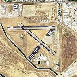 2006 USGS airphoto | |||||||||||||||
| Summary | |||||||||||||||
| Airport type | Public | ||||||||||||||
| Owner | City of Tracy | ||||||||||||||
| Operator | FBO SkyView Aviation LLC | ||||||||||||||
| Location | Tracy, California | ||||||||||||||
| Elevation AMSL | 193 ft / 59 m | ||||||||||||||
| Coordinates | 37°41′20″N 121°26′30″W / 37.68889°N 121.44167°W | ||||||||||||||
| Map | |||||||||||||||
 KTCY Location | |||||||||||||||
| Runways | |||||||||||||||
| |||||||||||||||
| Statistics (2005) | |||||||||||||||
| |||||||||||||||
Tracy Municipal Airport (ICAO: KTCY, FAA LID: TCY) is three miles (5 km) southwest of Tracy, in San Joaquin County, California. It is owned by the City of Tracy.[1]
Most U.S. airports use the same three-letter location identifier for the FAA and IATA, but Tracy Municipal Airport is TCY to the FAA and has no IATA code.
Facilities
Tracy Municipal Airport covers 310 acres (130 ha) and has two asphalt runways, 8/26 & 12/30, the longer one is 4,000 x 75 ft (1,220 x 23 m).[1]
In the year ending May 17, 2017 the airport had 60,000 aircraft operations, average 161 per day: 99% general aviation and 1% air taxi. 107 aircraft are based at the airport: 80 single engine, 4 multi-engine, 1 jet, 2 helicopters and 20 ultralight.[1]
World War II
During World War II the airport was Tracy Auxiliary Airfield (No 4), and was an auxiliary training airfield for Stockton Army Airfield, California.
See also
References
![]()
External links
- Tracy Municipal Airport at City of Tracy web site
- Resources for this airport:
- FAA airport information for TCY
- AirNav airport information for TCY
- FlightAware airport information and live flight tracker
- SkyVector aeronautical chart for TCY
| Flying Training |
|  | ||||
|---|---|---|---|---|---|---|
| Technical Training |
| |||||