Toula, Batroun
| Toula تولا | |
|---|---|
| Village | |
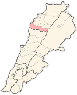
 Toula Location within Lebanon | |
| Coordinates: 34°11′59.7″N 35°43′29.8″E / 34.199917°N 35.724944°ECoordinates: 34°11′59.7″N 35°43′29.8″E / 34.199917°N 35.724944°E | |
| Country |
|
| Governorate | North Lebanon |
| District | Batroun |
| Highest elevation | 760 m (2,490 ft) |
| Lowest elevation | 460 m (1,510 ft) |
| Population (2007) | |
| • Total | 650 |
| Time zone | UTC+2 (EET) |
| • Summer (DST) | UTC+3 (EEST) |
| Dialing code | +961 |
Toula (Arabic: تولا ) is a village in Batroun District, North Governorate, Lebanon, 15 km far from Batroun. Situated at an altitude ranging from 460 meters above sea level at its lowest point, to 760 metres. It is known for its olive oil and figs. The residents are Christians. Its St-Doméce's (Mar Doumit) parish church dates back to 1270, it was restored in 1921 and has beautiful stone vaults inside. There are also the Slayyeb church and Mar Aabda's church.
Geography
- Elevation: 650 m
- Distance from Beirut: 61 km
- Distance from Tripoli: 43 km
- Distance from Batroun: 15 km
External links
http://www.localiban.org/article3719.html
Capital: Batroun | ||
| Towns and villages |
|  |
This article is issued from
Wikipedia.
The text is licensed under Creative Commons - Attribution - Sharealike.
Additional terms may apply for the media files.