Torrijos, Marinduque
| Torrijos | ||
|---|---|---|
| Municipality | ||
| Municipality of Torrijos | ||
| ||
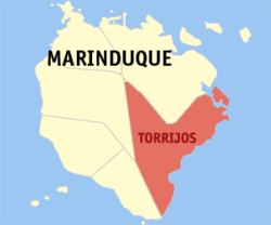 Map of Marinduque with Torrijos highlighted | ||
.svg.png) Torrijos Location within the Philippines | ||
| Coordinates: 13°19′N 122°05′E / 13.32°N 122.08°ECoordinates: 13°19′N 122°05′E / 13.32°N 122.08°E | ||
| Country |
| |
| Region | Mimaropa (Region IV-B) | |
| Province | Marinduque | |
| District | Lone district of Marinduque | |
| Founded | 1880 | |
| Barangays | 25 (see Barangays) | |
| Government [1] | ||
| • Type | Sangguniang Bayan | |
| • Mayor | Lorna Velasco | |
| • Vice Mayor | Ricardo de Galicia | |
| • Electorate | 16,984 voters (2016) | |
| Area [2] | ||
| • Total | 178.92 km2 (69.08 sq mi) | |
| Population (2015 census)[3] | ||
| • Total | 30,524 | |
| • Density | 170/km2 (440/sq mi) | |
| Time zone | UTC+8 (PST) | |
| ZIP code | 4903 | |
| PSGC | 174006000 | |
| IDD : area code | +63 (0)42 | |
| Climate type | Tropical climate | |
| Income class | 3rd municipal income class | |
| Revenue (₱) | 94,725,918.56 (2016) | |
| Native languages | Tagalog | |

Torrijos, officially the Municipality of Torrijos, is a 3rd class municipality in the province of Marinduque, Philippines. According to the 2015 census, it has a population of 30,524 people.[3]
Barangays
Torrijos is politically subdivided into 25 barangays. [2]
- Bangwayin
- Bayakbakin
- Bolo
- Bonliw
- Buangan
- Cabuyo
- Cagpo
- Dampulan
- Kay Duke
- Mabuhay
- Makawayan
- Malibago
- Malinao
- Maranlig
- Marlangga
- Matuyatuya
- Nangka
- Pakaskasan
- Payanas
- Poblacion
- Poctoy
- Sibuyao
- Suha
- Talawan
- Tigwi
History
On September 13, 1900, during the Philippine-American War an engagement in Torrijos pitted the forces of Philippine Revolutionary Army Colonel Maximo Abad against the Americans led by Captain Devereux Shields. Abad's men defeated the American force, it was one of the worst defeats suffered by the Americans during the war. This was known as the Battle of Pulang Lupa which took place in Torrijos. A monument now stands on the mountain where the battle took place, known as Pulang Lupa or "Red Mountain" due to the red soil.
In 1942, the Japanese occupied the town of Torrijos, Marinduque.
In 1945, in the Battle of Marinduque, American and Filipino troops fought in and around the town of Torrijos and Marinduque against the Japanese soldiers during World War II.
Demographics
| Population census of Torrijos | ||
|---|---|---|
| Year | Pop. | ±% p.a. |
| 1903 | 4,275 | — |
| 1918 | 4,933 | +0.96% |
| 1939 | 8,974 | +2.89% |
| 1948 | 10,697 | +1.97% |
| 1960 | 14,885 | +2.79% |
| 1970 | 18,137 | +1.99% |
| 1975 | 20,762 | +2.75% |
| 1980 | 22,255 | +1.40% |
| 1990 | 25,496 | +1.37% |
| 1995 | 25,807 | +0.23% |
| 2000 | 28,000 | +1.76% |
| 2007 | 29,360 | +0.66% |
| 2010 | 29,366 | +0.01% |
| 2015 | 30,524 | +0.74% |
| Source: Philippine Statistics Authority[3][4][5][6] | ||
In the 2015 census, the population of Torrijos, Marinduque, was 30,524 people,[3] with a density of 170 inhabitants per square kilometre or 440 inhabitants per square mile.
Educational institutions
Tertiary
- Marinduque State College
- Torrijos Poblacion School of Arts and Trades (TPSAT)
Secondary
- Bonliw National High School
- Malibago National High School
- Maranlig National High School
- Matuyatuya National High School
- Poctoy National High School
- Sibuyao National High School
- Tigwi National High School
- Our Mother of Perpetual Succor Academy
Primary
- Bangwayin Primary School
- Banukbok Primary School
- Bayakbakin Primary School
- Bolo Primary School
- Bonliw Elementary School
- Buangan Elementary School
- Cabuyo Elementary School
- Cagpo Primary School
- Dampulan Elementary School
- Kay Duke Primary School
- Mabuhay Primary School
- Makawayan Elementary School
- Malibago Elementary School
- Malinao Primary School
- Maranlig Elementary School
- Marlangga Elementary School
- Matuyatuya Elementary School
- Nangka Elementary School
- Pakaskasan Primary School
- Payanas Elementary School
- Poctoy Elementary School
- Sibuyao Elementary School
- Sinambahan Primary School
- Suha Elementary School
- Talawan Elementary School
- Tigwi Elementary School
- Torrijos Central School
Places of Interest
- Torrijos White Beach (also known as Poctoy White Beach Resort, Barangay Poctoy)
- Battle of Pulang Lupa Monument (Barangay Bolo)
- Ka Amon Cave (Barangay Bonliw)
- Freedom Park (also known as Luneta Park, Barangay Poblacion)
- Sibuyao Farms
- Bonliw Loom Weaving (Barangay Bonliw)
- Tabag Cliff and River (Barangay Malibago)
References
- ↑ "Municipality". Quezon City, Philippines: Department of the Interior and Local Government. Retrieved 31 May 2013.
- 1 2 "Province: Marinduque". PSGC Interactive. Quezon City, Philippines: Philippine Statistics Authority. Retrieved 12 November 2016.
- 1 2 3 4 Census of Population (2015). "Region IV-B (Mimaropa)". Total Population by Province, City, Municipality and Barangay. PSA. Retrieved 20 June 2016.
- ↑ Census of Population and Housing (2010). "Region IV-B (Mimaropa)". Total Population by Province, City, Municipality and Barangay. NSO. Retrieved 29 June 2016.
- ↑ Censuses of Population (1903–2007). "Region IV-B (Mimaropa)". Table 1. Population Enumerated in Various Censuses by Province/Highly Urbanized City: 1903 to 2007. NSO.
- ↑ "Province of Marinduque". Municipality Population Data. Local Water Utilities Administration Research Division. Retrieved 17 December 2016.
External links
- Philippine Standard Geographic Code*
- Official Website of Municipality of Torrijos*
- Philippine Census Information
- Local Governance Performance Management System
Places adjacent to Torrijos, Marinduque | ||||||||||
|---|---|---|---|---|---|---|---|---|---|---|
| ||||||||||
Boac (capital) | |
| Municipalities | |