Torre-Pacheco
| Torre-Pacheco | |||
|---|---|---|---|
| Municipality | |||
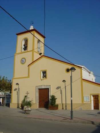 The church of San Cayetano (Murcia) | |||
| |||
 Torre-Pacheco Location in Spain | |||
| Coordinates: 37°44′35″N 0°57′14″W / 37.74306°N 0.95389°W | |||
| Country |
| ||
| Autonomous Community |
| ||
| Province | Region of Murcia | ||
| Comarca | Comarca del Mar Menor | ||
| Government | |||
| • Mayor | Daniel García Madrid (PP) | ||
| Area | |||
| • Total | 189 km2 (73 sq mi) | ||
| Elevation(AMSL) | 40 m (130 ft) | ||
| Population (2017) | |||
| • Total | 35,198 | ||
| • Density | 190/km2 (480/sq mi) | ||
| Time zone | UTC+1 (CET) | ||
| • Summer (DST) | UTC+2 (CEST (GMT +2)) | ||
| Postal code | 30700 | ||
| Area code(s) | +34 (Spain) + 968 (Murcia) | ||
| Website | www.torrepacheco.es | ||
.svg.png)
.svg.png)
Torre-Pacheco (Spanish pronunciation: [torepaˈtʃeko]) is a municipality in the autonomous region of Murcia in southeastern Spain. It has a population of 35,198 as of 2017, and an area of 189.4 km². The only elevation of the municipality is the Cabezo Gordo, the location of the Sima de las Palomas, a protected archeological site. The town is home to one further education college called "I.E.S. Gerardo Molina".
Geography
This municipality is located in the region Campo de Cartagena. There are very few mountain relieves; a notable one is a hill named Cabezo Gordo with a height of 312 metres. There are not any beds which have water in constantly, but there are some ravines, which flow into Mar Menor (a coastal salty lagoon) in rainy periods. The ground of this area is mainly composed of sedimentary materials (loam, sandstone and limestone).[1]
Torre-Pacheco is semi-enclosed in the North by some mountain ranges such as Columbares, Carrascoy, El Puerto, Escalona and Altalona. The South is also enclosed by the mountain ranges of La Unión, Roldán, La Muela, Las Victorias and Cartagena.[1]
These mountain relieves highly influence the climate of the territory. The values of precipitation are usually lower than 300 milimetres and when it rains, the precipitations are usually downpours or torrential rains. The most rainy seasons are autumm and spring and the most rainy months are October and April. Its climate is mediterranean semi-arid. The temperatures are generally high, at a yearly average of 18 °C. Summers are hot, but can feel mild due to the sea breezes. Winters are mild, with an average temperature of 10 °C.[1]
This territory has been highly anthropizated, especially from the 1950s and 1960s, owing to the mechanization in agriculture.[1]
Demography
There were 35,198 inhabitants in the year 2017 and they are distributed in the following localitites: Torre-Pacheco, where 18,003 people live; Roldán, whose population is 6,642; Balsicas which has a population of 3,181; Dolores, which has 2,271 inhabitants; Jimenado, where 1,192 people live; San Cayetano, with 1,207; Hortichuela, whose population is 585; Santa Rosalía, where 185 people reside; El Abardinal, which has a population of 218; Los Camachos, where 173 people live and Hoyamorena with 1076.[2][3]
History
The area of the current municipality of Torre-Pacheco was inhabited from the Lower Paleolithic. In a hill named Cabezo Gordo there is a paleontological site whose name is Sima de Las Palomas. This place shows the presence of individuals belonging to the species Homo heidelbergensis. These creatures inhabited this territory in the period from 150,000 BC to 125,000 BC. Neanderthals also lived in this area from 120,000 BC to 35,000 BC.[4]
Torre-Pacheco was also inhabited by people in the period of the Roman presence in the Iberian Peninsula. In that era there was not any town in Torre-Pacheco, but 16 Roman villas were found. The romans extracted marble from a deposit in Cabezo Gordo. In this territory, economical activities such as the agriculture and the ranching due to the fruitful ground of the territory were performed.[5]
The first historic mentions to Torre-Pacheco have date in the 13th century.[6]
In the Late Middle Ages families whose members were landowners settled in this territory and their surnames named the towns and villages of this current municipality. The Saavedra family came from Galicia, the Roda family came from Navarra, and the Pacheco family came from Portugal. On 7 November 1478, the council of Murcia sent a grant to Pedro Pacheco, who was the founder of Torre-Pacheco. The tower and the country property, which were constructed by Pedro Pacheco, were the origin of this town, that rose up from a villa. This locality took its name from the surname of its founder.[6]
These families procured lands and built farmland houses in order to monitor the agriculture and livestock activities; buildings and some hamlets were established in these areas. Owing to their distance from castles and mountains, these towers were their only protection. The purpose of these constructions was communicating with the population, and sheltering the inhabitants from the raids from Berber, which menaced the locals from the 13th century to the 18th century.[6]
In the mid-16th century, there was an increase in the population of Campo de Cartagena (natural region which this territory belongs to). This increase continued during the 17th century as more people were arriving in the territory and some family linages began to occupy farming houses.[7]
The first localities in this region were Los Álcazares, Fuente Álamo and Torre-Pacheco. Before the appearance of these population centres, there were just a disperse distribution of the buildings.[7]
From the 16th century to the 18th century, new localities such as Balsicas, Roldán, Dolores y Lo Ferro appeared. The latter has its origin in a family of Genoese people settled in Murcia, which procured lands in this region. In the 17th century small churches and chapels were built, and two of them gave the name to the villages San Cayetano and Los Dolores.[7]
In the year 1813 the area of Torre-Pacheco got a town council for the first time and became independent from the municipality of Murcia. This happened with the agreement with the Spanish Constitution of 1812, but this document was nullified the following year. During the Trienio Liberal (1820-1823) Torre-Pacheco's town council was formed again. On 17 September 1836, a town council was established in the territory permanently.[8]
In the year 1900 this area was populated by 8,549 inhabitants. Half a century after, this territory was inhabited by 10,409 people.[8]
During a great part of this historical period, the unemplyment of the working people was a problem in Torre-Pacheco. In this municipality, non-irrigated agriculture was almost the only way the locals made a living, and they grew cereals, almond trees, grapevines and olive trees.[8]
Nowadays, modern technology and the presence of many working foreigners has led agriculture to be a major economic industry of Torre-Pacheco and its region. The main crop products are artichoke, lettuce, broccoli, watermelon and melon.[8]
Main sights
Institute for performing arts C.A.E.S.
The C.A.E.S. is an archetypal building with a modern style and it has a surface of 4000 m2. It has been planified for being home to cultural expression and art acts such as drama, dance, music and cinema. It holds an auditorium with 600 places.[9]
This building was opened on 16 September 2006.[9]
The town library
This edifice was opened on 23 January 2007.[9]
The building has an area of 2,204 m2 and it is part of a developed 18,000 m2 open area. It is situated in a semi-underground floor, where there are several heights joined by ramps. The building holds a "night-open silence area", class and conference rooms and a reading and study room. In addition, there is an art gallery for exhibitions.[9]
The most noteworthy component of this architectural complex is the outdoor reading park.[9]
Nuestra Señora del Rosario Church Tower
In this municipality there was an ancient church, which was more than three centuries old. The body of the Ministry of Culture of Spain Dirección General de Bellas Artes did not declare that building as an artistic-historical monument, therefore it was razed in the year 1971 due to an order of the bisphoric.[9]
The first stone of the new tower was laid in 2005. On 7 October 2010 the bells rang for the first time in 38 years. This tower was unveiled on 6 January 2011.[9]
Some historical sights
Castle of Ros
In the year 1844, Antonio Ros de Olano y Perpigná bought some lands in the hamlet Balsicas. He was a soldier assigned to Cartagena. The queen Isabella II of Spain granted Antonio Ros the ranks viscount of de Ros de Olano and marquis of Gaud-el-Yehi.[10]
This building received some alterations which were carried out by the son and the grandson of Antonio Ros de Olano. This construction is an ancient ramshackle house with a turret.[10]
Casa Valderas
This recreation property was built in the last years of the 19th century. It is surrounded by vegetable gardens. Its architectural style is neoclassical.[11]
Festivities
- El Pasico Festivity: This is a popular festivity which is held surrounding the El Pasico Shrine. The date of the celebration is Easter Mondays. This festivity consists in a mass to which held in El Pasico Shrine and next in a set of non-permanent-staying amusement rides. In the evening, locals eat a traditional confectionery foostuff named mona de Pascua.[12]
- Melon Festivity: The melon started to be grown in the early 20th century in the municipality. A former mayor of Torre-Pacheco decided to establish this Melon Festivity in the year 1969.[13]
Notable people
- Antonio Ros de Olano (1808-1886): writer, politician and soldier. As a soldier, he took place in the First Carlist War (1833-1840) and in the Hispano-Moroccan War (1859-1860), in which he had a determining influence. In regards to his politics career, he was minister of the Spanish nineteenth-century ministery of Trade, Education and Public Constructions. He was also a lifelong senator from 1877. In addition, he had the nineteenth-century charge of 'jefe político superior' (literally translated 'politic top head'). This charge consisted of being the top politics public worker and administrative of one of the provinces of Spain in that era. Antonio Ros was also one of the founder of the Spanish nineteenth-century political party Unión Liberal. [14]
- Pedro Cerdán Martínez (1863-1947): architect. He designed notable buildings in La Unión such as Antiguo Mercado Público de La Unión (the building for the former public market).[15]
- Luis Manzanares (1895-1980): writer.[16]
- Alberto Garre López (1952): politician, president of Region of Murcia from 2014 to 2015.[17][18]
References
- 1 2 3 4 "Torre-Pacheco - Historia - Historia de Torre-Pacheco - Ayuntamiento de Torre-Pacheco".
- ↑ "Torre-Pacheco - Pedanías - Otras - Ayuntamiento de Torre-Pacheco".
- ↑ "INEbase / Demography and population /Municipal Register. Population by municipalities /Nomenclature: Continuous Register Population by Population Unit / Results".
- ↑ "Historia de Torre Pacheco- Prehistoria - Región de Murcia Digital".
- ↑ "Historia de Torre Pacheco- Antigüedad - Región de Murcia Digital".
- 1 2 3 "Historia de Torre Pacheco- Edad Media - Región de Murcia Digital".
- 1 2 3 "Historia de Torre Pacheco- Edad Moderna - Región de Murcia Digital".
- 1 2 3 4 "Historia de Torre Pacheco- Edad Contemporánea - Región de Murcia Digital".
- 1 2 3 4 5 6 7 "Torre-Pacheco - Patrimonio - Torre-Pacheco Contemporáneo - Ayuntamiento de Torre-Pacheco".
- 1 2 "Torre-Pacheco - Pedanías - Balsicas - Ayuntamiento de Torre-Pacheco".
- ↑ "Casa Valderas - Región de Murcia Digital". www.regmurcia.com (in Spanish). Retrieved 2018-08-20.
- ↑ "Turismo - Fiestas - Fiesta de El Pasico - Ayuntamiento de Torre-Pacheco" (in Spanish). Retrieved 2018-10-01.
- ↑ "Turismo - Fiestas - Fiestas del Melón - Ayuntamiento de Torre-Pacheco" (in Spanish). Retrieved 2018-10-01.
- ↑ "Antonio Ros de Olano - Región de Murcia Digital" (in Spanish). Retrieved 2018-09-16.
- ↑ "Pedro Cerdán Martínez - Región de Murcia Digital" (in Spanish). Retrieved 2018-09-16.
- ↑ "Luis Manzanares - Región de Murcia Digital" (in Spanish). Retrieved 2018-09-16.
- ↑ "Garre López, Alberto" (in Spanish). Retrieved 2018-09-16.
- ↑ "El expresidente Alberto Garre monta las bases de su futuro partido regionalista - La Verdad" (in Spanish). Retrieved 2018-09-16.
External links
- Ayuntamiento de Torre-Pacheco (in Spanish)
- Torre-Pacheco - Región de Murcia Digital (in Spanish)
This article contains information from the Spanish Wikipedia article Torre Pacheco, accessed on January 11, 2008.