Topolnitsa River
| Topolnitsa | |
|---|---|
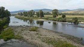 The Topolnitsa as seen from Trakiya motorway | |
| Country | Bulgaria |
| Physical characteristics | |
| River mouth |
Maritsa 42°11′16″N 24°18′02″E / 42.1877°N 24.3006°ECoordinates: 42°11′16″N 24°18′02″E / 42.1877°N 24.3006°E |
| Length | 135.6 km (84.3 mi)[1] |
| Basin features | |
| Progression | Maritsa→ Aegean Sea |
| Basin size | 1,780 km2 (690 sq mi)[1] |
The Topolnitsa (Bulgarian: Тополница) is a river in southern Bulgaria, an important left tributary of the Maritsa. It takes its source from Bich Peak in Sredna Gora close to Koprivshtitsa; it is known as the Shirineyska in its upper course. Its average discharge is 55 m³/s and it is 135.6 kilometres (84.3 mi) long; its drainage basin covers 1,780 square kilometres (690 sq mi).[1] The Topolnitsa flows into the Maritsa near Pazardzhik after making a large turn under Trakiya motorway. The Topolnitsa Reservoir has a maximum volume of 120,000,000 cubic metres (4.2×10⁹ cu ft) and serves the area around Pazardzhik. Among the Topolnitsa's tributaries are the Mativir and the Bunovo River. The river's name is derived from the Bulgarian word топола, topola ("poplar").
References
- "Тополница". Българска енциклопедия А-Я (in Bulgarian). БАН, Труд, Сирма. 2002. ISBN 954-8104-08-3. OCLC 163361648.
| Wikimedia Commons has media related to Topolnitsa. |