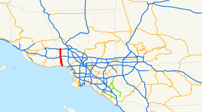
California State Route 27
| ||||
|---|---|---|---|---|
| Topanga Canyon Boulevard | ||||
 SR 27 | ||||
| Route information | ||||
| Defined by Streets and Highways Code § 327 | ||||
| Maintained by Caltrans | ||||
| Length | 19.974 mi[1] (32.145 km) | |||
| Existed | 1963[1] – present | |||
| Major junctions | ||||
| South end |
| |||
|
| ||||
| North end |
| |||
| Location | ||||
| Counties | Los Angeles | |||
| Highway system | ||||
| ||||

State Route 27 is a state highway in the U.S. state of California that runs from Pacific Coast Highway (PCH) at Topanga State Beach near Pacific Palisades, through Topanga Canyon including the community of Fernwood Pacific also known as Topanga, and continuing through Woodland Hills, Canoga Park, West Hills, and Chatsworth to Ronald Reagan Freeway. The entire route is commonly known by its street name, Topanga Canyon Boulevard.
As one of the only routes across the Santa Monica Mountains, Route 27 is heavily traveled by commuters from the western San Fernando Valley heading to Santa Monica or Interstate 10.
Route description
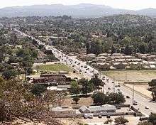
SR 27 begins at SR 1 right next to the Pacific Ocean and Topanga County Beach, in an unincorporated area of Los Angeles County between Malibu and Castellammare. It travels north as Topanga Canyon Boulevard, cutting through Topanga State Park. Upon exiting the park, SR 27 provides access to Fernwood, Topanga, Sylvia Park, and Glenview, all unincorporated. SR 27 continues winding into the San Fernando Valley, nearly entering Calabasas before entering the Los Angeles community of Woodland Hills. The route becomes a major city arterial through the valley, intersecting US 101 before entering Warner Center and Canoga Park. After traversing Chatsworth, SR 27 ends just past an interchange with the SR 118 freeway, thus providing access to the unincorporated area north of Chatsworth.[2]
Metro Local line 245 runs on Topanga Canyon Boulevard.
Except for a small portion in the mountains, SR 27 is part of the National Highway System,[3] a network of highways that are considered essential to the country's economy, defense, and mobility by the Federal Highway Administration.[4] SR 27 is eligible for the State Scenic Highway System.[5] A portion has been officially designated as a scenic highway by the California Department of Transportation.[6][7]
History
The original state highway system in 1933 included a highway from near Topanga Beach to Montalvo-San Fernardo Road near Chatsworth.[8] Two years later, this was numbered as Route 156.[9] The route was redesignated as SR 27 in the 1964 state highway renumbering.[10]
Major intersections
Except where prefixed with a letter, postmiles were measured on the road as it was in 1964, based on the alignment that existed at the time, and do not necessarily reflect current mileage. R reflects a realignment in the route since then, M indicates a second realignment, L refers an overlap due to a correction or change, and T indicates postmiles classified as temporary (for a full list of prefixes, see the list of postmile definitions).[1] Segments that remain unconstructed or have been relinquished to local control may be omitted. The entire route is in Los Angeles County.
| Location | Postmile [1][11][12] | Destinations | Notes | ||
|---|---|---|---|---|---|
| | 0.00 | South end of SR 27 | |||
| Los Angeles | 11.06 | Mulholland Drive | Former SR 268 | ||
| 12.28 | Ventura Boulevard | Former US 101 and US 101 Bus. | |||
| 12.43 | Interchange | ||||
| | Victory Boulevard | ||||
| 18.63 | Devonshire Street – San Fernando | Former SR 118 east | |||
| | Santa Susana Pass Road | Former SR 118 west | |||
| 20.06 | Interchange; north end of SR 27 | ||||
| 20.06 | Poema Place, Mayan Drive | Continuation beyond SR 118 | |||
| 1.000 mi = 1.609 km; 1.000 km = 0.621 mi | |||||
See also

References
- 1 2 3 4 California Department of Transportation. "State Truck Route List". Sacramento: California Department of Transportation. Archived from the original (XLS file) on June 30, 2015. Retrieved June 30, 2015.
- ↑ Los Angeles County Road Atlas (Map). Thomas Brothers. 2008.
- ↑ Federal Highway Administration (March 25, 2015). National Highway System: Los Angeles, CA (PDF) (Map). Scale not given. Washington, DC: Federal Highway Administration. Retrieved October 18, 2017.
- ↑ Natzke, Stefan; Neathery, Mike & Adderly, Kevin (June 20, 2012). "What is the National Highway System?". National Highway System. Washington, DC: Federal Highway Administration. Retrieved July 1, 2012.
- ↑ California State Legislature. "Section 260–284". Streets and Highways Code. Sacramento: California State Legislature. Retrieved June 9, 2017.
- ↑ California Department of Transportation (September 7, 2011). "Officially Designated State Scenic Highways and Historic Parkways". Sacramento: California Department of Transportation.
- ↑ Tallal, Jimy (October 20, 2017). "Topanga Canyon Boulevard Named State Scenic Highway". The Malibu Times. Retrieved 21 October 2017.
- ↑ California State Assembly. "An act to amend sections 2, 3 and 5 and to add two sections to be numbered 6 and 7 to an act entitled 'An act to provide for the acquisition of rights of way for and the construction, maintenance..." Fiftieth Session of the Legislature. Statutes of California. State of California. Ch. 767 p. 2034–2042.
- ↑ California State Assembly. "An act...relating to State highways". Fifty-first Session of the Legislature. Statutes of California. State of California. Ch. 274.
- ↑ California State Assembly. "An act to add Section 253 and Article 3 (commencing with Section 300) to Chapter 2 of Division 1 of, and to repeal Section 253 and Article 3 (commencing with Section 300) of Chapter 2 of Division 1 of, the..." 1963 Session of the Legislature. Statutes of California. State of California. Ch. 385 p. 1182.
- ↑ California Department of Transportation (July 2007). "Log of Bridges on State Highways". Sacramento: California Department of Transportation.
- ↑ California Department of Transportation, All Traffic Volumes on CSHS, 2005 and 2006
External links
Route map:
| Wikimedia Commons has media related to California State Route 27. |