Tongatapu
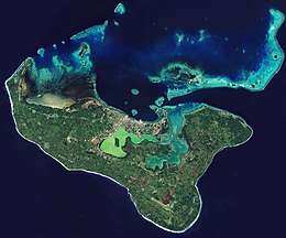 Satellite picture of Tongatapu | |
 | |
| Geography | |
|---|---|
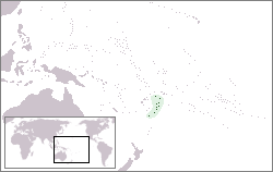
| Location | Pacific Ocean |
| Coordinates | 21°12′41″S 175°09′11″W / 21.21139°S 175.15306°W |
| Archipelago | Tonga Islands |
| Area | 260.48 km2 (100.57 sq mi) |
| Highest elevation | 65 m (213 ft) |
| Highest point | Unnamed |
| Administration | |
|
Tonga | |
| Largest settlement | Nukuʻalofa (pop. 22,400) |
| Demographics | |
| Population | 75,416 (2011) |
| Pop. density | 273.57 /km2 (708.54 /sq mi) |
| Ethnic groups | Tongan (majority), European, Chinese, Pacific Islanders. |
Tongatapu is the main island of the Kingdom of Tonga and the location of its capital Nukuʻalofa. It is located in Tonga's southern island group, to which it gives its name, and is the country's most populous island, with approximately 71,260 residents (2006), 70.5% of the national population, on 260 square kilometres (100 square miles). Its maximum height is 65 metres (213 feet). Tongatapu is Tonga's centre of government and the seat of its monarchy.
Tongatapu, as a commercial and transport hub, has (led by Nukuʻalofa) experienced more rapid economic development than, as well as attracting many internal migrants from, the other islands of the Kingdom.
Geography
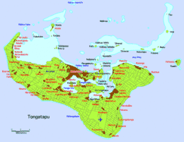
The island is 257.03 square kilometres (99.24 square miles) (or 260.48 square kilometres (100.57 square miles) including neighbouring islands) and rather flat, as it is built of coral limestone. The island is covered with thick fertile soil consisting of volcanic ash from neighboring volcanoes. At the steep coast of the south, heights reach an average of 35 metres (115 feet) gradually decreasing towards the north is 'Atata Island, about a 30-minute boat ride from Tongatapu.]]
North of the island are many small isolated islands and coral reefs which extend up to 7 kilometres (4.3 miles) from Tongatapu's shores. The almost completely closed Fanga'uta and Fangakakau Lagoons are important breeding grounds for birds and fish as they live within the mangroves growing around the lagoon's shores. The lagoons were declared a Natural Reserve in 1974 by the government.
The island has only but a few sandy beaches because of its raised coastlines apart from the many small islands in the north boasting some of the best beaches in Tongatapu.
Climate
Tongatapu has a rather cooler climate than the rest of Tonga as it is the southernmost group of islands in the country. Because of this, fruit production is lower in Tongatapu than it is in the warmer islands in the north.
History
People of the Lapita culture
Tongatapu is known as having one of the highest concentration of archaeological remains in the Pacific. The earliest traces of Lapita pottery found in Tonga was from around 900–850 BCE, 300 years after the first settlements in Tonga were established. Archaeologist David Burley discovered the pottery around the Fanga'uta Lagoon, 2,000 kilometres (1,200 miles) away from the Lapita pottery found at Santa Cruz in the Solomon Islands.
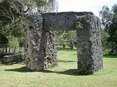
Although Tonga was always the seat of the Tongan Empire, but in an area of distances up to 1,000 kilometres (620 miles), it was often only a symbolic rule. From the first capital at Toloa, around 1000 years ago, to the second capital at Heketā, at the site of the Ha'amonga 'a Maui Trilithon, none boasts more traditional attractions than the third capital at Mu'a (from 1220–1851) with more than 20 royal grave mounds.
Europeans
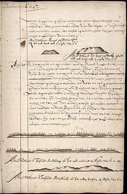
Tongatapu was first sighted by Europeans on 20 January 1643 by Abel Janszoon Tasman commanding two ships, the Heemskerck and the Zeehaen commissioned by the Dutch East India Company of Batavia (Jakarta). The expedition's goals were to chart the unknown southern and eastern seas and to find a possible passage through the South Pacific and Indian Ocean providing a faster route to Chile. The expedition set sail from Batavia on 14 August 1642. Tasman named the island "t’ Eijlandt Amsterdam" (Amsterdam Island), because of its abundance of supplies.[2] This name is no longer used except by historians.
Captain James Cook, sailing the British vessel Resolution visited the island on October 2, 1773 by some accounts[3] and by other accounts[4] October 1774, returning again in 1777 , with Omai,[5] whereupon they left some cattle for breeding. These were still flourishing in 1789 when Bounty, under Fletcher Christian visited.
Spelling
The earliest mention of Tongataboo was recorded by Captain Cook in 1777 as he wrote his memoirs for the Three Voyages Around the World, Volume 1.
Main sights
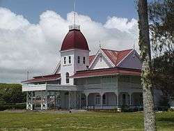
- Nukuʻalofa – Capital of Tonga
- Muʻa – Second largest town in Tongatapu. Site of the ancient burial mounds and the Papae 'o Tele'a Tombs.
- Langi – Tombs of Tongan kings
- Hule Fortress -Located in Nukunuku - Kolotau Ko Hule - Western District of Hihifo (Largest Town in Tongatapu a.k.a The City)
- Mapu ʻa Vaea – Blowholes in the coral reef on the south-western side
- Hūfangalupe – Natural landbridge on the south eastern side of Tongatapu
- Pangaimotu – Small resort island close to Nukuʻalofa
- Landing site of Captain Cook
- Flying Fox Preserve – Located in Kolovai in the western side Taungapeka
- Haʻamonga ʻa Maui – Trilithon
- Nukuleka – possibly the site of first Lapita settlement in Tonga
- Tupou College – first educational establishment in the kingdom located in the eastern district of Tongatapu near Malapo
See also
References
- ↑ Nationaal Archief, archiefinventaris 1.11.01.01 inventarisnummer 121, scan 85 hdl:10648/877f659e-35ce-4059-945e-294a4d05d29c
- ↑ Hooker, Brian (2013). "The European Discovery of the Tonga Islands". Terrae Incognitae. 36: 20. doi:10.1179/tin.2004.36.1.20.
- ↑ "The Kingdom Of Tonga | Three Millennia of History". www.thekingdomoftonga.com. Retrieved 2018-05-15.
- ↑ "A Cook's Tour of Tonga". The Captain Cook Society (CCS). Retrieved 2018-05-15.
- ↑ Salmond, Anne (2010). Aphrodite's Island. Berkeley: University of California Press. pp. 291, 412. ISBN 9780520261143.
External links
| Wikivoyage has a travel guide for Tongatapu. |
- Tonga Quick Facts
- photographs from Tongatapu, Tonga
- The European discovery of the Tonga Islands by Brian Hooker
Coordinates: 21°12′41″S 175°09′11″W / 21.21139°S 175.15306°W