Cockburn Island (Ontario)
| Cockburn Island | |
|---|---|
| Township (single-tier) | |
| Township of Cockburn Island | |
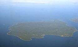 Aerial view of Cockburn Island | |
 Cockburn Island | |
| Coordinates: 45°55′N 83°23′W / 45.917°N 83.383°WCoordinates: 45°55′N 83°23′W / 45.917°N 83.383°W | |
| Country | Canada |
| Province | Ontario |
| District | Manitoulin |
| Settled | ca. 1880 |
| Government | |
| • Reeve | Brenda Jones |
| • Federal riding | Algoma—Manitoulin—Kapuskasing |
| • Prov. riding | Algoma—Manitoulin |
| Area[1] | |
| • Land | 171.04 km2 (66.04 sq mi) |
| Population (2011)[1] | |
| • Total | 0 |
| • Density | 0/km2 (0/sq mi) |
| Time zone | UTC-5 (EST) |
| • Summer (DST) | UTC-4 (EDT) |
| Postal Code FSA | P0P |
| Area code(s) | 705 |
Cockburn Island is an island and municipality in the Canadian province of Ontario, located in the Manitoulin District. It is separated from the westernmost point of Manitoulin Island by the Mississagi Strait, and from Michigan's Drummond Island by the False Detour Channel.
The island is incorporated as and coterminous with the municipal Township of Cockburn Island. With an official population of zero in the Canada 2011 Census, and populations varying between zero and ten people in the previous three censuses, Cockburn Island is the least populated incorporated municipality in Canada. However, the population grows significantly in the summer, as an estimated two to three hundred people maintain cottages and summer homes on the island.[2] Township offices are located on the mainland in Thessalon in Algoma District.
Until 2010, a small portion (3.44 square kilometres (1.33 sq mi)) of the north-west side of the island was taken up by the Cockburn Island 19 Indian reserve, which had no permanent population — this was heritage land belonging to a First Nation whose primary community is located on Manitoulin Island. On January 2, 2010, it was dissolved and added to Cockburn Island Township.[3]
History
The island was named for Francis Cockburn, a deputy quartermaster of Upper and Lower Canada in the early 19th century.
At one time, the island had a population of several hundred people, reaching a peak of over 1000 residents before World War II. Life was centred primarily on fishing operations at Tolsmaville (45°57′29″N 83°19′05″W / 45.95806°N 83.31806°W), which was once also known as Port Cockburn, and logging operations at Ricketts Harbour. Tolsmaville continues to be the primary settlement on the island, operating as the hub of the island's summer tourist economy, even though some references incorrectly describe it as a wholly abandoned ghost town.[4]
In addition to the summer recreational economy, a modest logging industry continues to operate on the island.
Transportation
The island is not connected to either Manitoulin or Drummond Islands, or to the mainland, by bridge or ferry service. The municipality maintains a marina at Tolsmaville for private boats and float planes,[5] and a small grass airstrip located west of Tolsmaville provides a landing area for private planes.[6]
Historically, when the island had a larger permanent resident population, it received ferry service, most notably from the MS Norgoma.[7] The island's population declined rapidly when the ferry service was discontinued in the late 1960s, being reduced to only one round trip from Meldrum Bay per week.
Demographics
| Canada census – Cockburn Island (Ontario) community profile | |||
|---|---|---|---|
| 2011 | 2006 | ||
| Population: | 0 (-100% from 2006) | 10 (% from 2001) | |
| Land area: | 171.04 km2 (66.04 sq mi) | 167.60 km2 (64.71 sq mi) | |
| Population density: | 0/km2 (0/sq mi) | 0.1/km2 (0.26/sq mi) | |
| Median age: | |||
| Total private dwellings: | 79 | 90 | |
| Median household income: | |||
| References: 2011[1] 2006[8] earlier[9] | |||
There was a permanent population of ten in the 2006 Canadian census.[10] In the 2001 census the island's population had been reported as zero,[10] due to Statistics Canada's counting method of rounding off population figures for communities of smaller than 15 people; in the 1996 census it had a reported population of two.
See also
References
- 1 2 3 "2011 Community Profiles". Canada 2011 Census. Statistics Canada. July 5, 2013. Retrieved 2012-02-22.
- ↑ Guide to the North Channel of Lake Huron, continuouswave.com.
- ↑ "Annual changes to census subdivision codes, names and types, between 2006 and 2011, by province and territory, and by year". Standard Geographical Classification (SGC) 2011. Statistics Canada. Retrieved 2012-02-22.
- ↑ Ontario Ghost Towns: Tolsmaville/Port Cockburn
- ↑ "Tolsmaville, Cockburn Island, Ontario -- A Lively Ghost Town", greatlakescruising.blogspot.com.
- ↑ Cockburn Island on Googlesightseeing.com.
- ↑ MS Norgoma: The History of the Turkey Trail.
- ↑ "2006 Community Profiles". Canada 2006 Census. Statistics Canada. March 30, 2011. Retrieved 2012-02-22.
- ↑ "2001 Community Profiles". Canada 2001 Census. Statistics Canada. February 17, 2012.
- 1 2 Canada 2006 Census: Cockburn Island community profile.
Places adjacent to Cockburn Island (Ontario) | |
|---|---|