Drummond Township, Michigan
| Drummond Township, Michigan | |
|---|---|
| Civil township | |
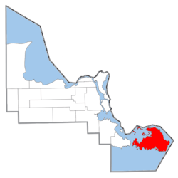 Location within Chippewa County | |
 Drummond Township Location within the state of Michigan | |
| Coordinates: 46°00′N 83°40′W / 46.000°N 83.667°WCoordinates: 46°00′N 83°40′W / 46.000°N 83.667°W | |
| Country | United States |
| State | Michigan |
| County | Chippewa |
| Area | |
| • Total | 249.0 sq mi (644.9 km2) |
| • Land | 128.9 sq mi (333.9 km2) |
| • Water | 120.1 sq mi (311.0 km2) |
| Elevation | 741 ft (247 m) |
| Population (2010) | |
| • Total | 1,058 |
| • Density | 8/sq mi (3.2/km2) |
| Time zone | Eastern |
| FIPS code | 26-23080[1] |
| GNIS feature ID | 1626193[2] |
Drummond Island Township is a civil township of Chippewa County in the U.S. state of Michigan. The population was 1,058 at the 2010 census.[3]
The township consists of Drummond Island, one of the largest islands in Lake Huron.[4] M-134 runs through the western portion of the island. The highway connects with the mainland portion via the Drummond Island Ferry, which runs between De Tour Village and the island.
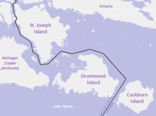
On the east side of Drummond Island, the Canada–United States border passes through the False Detour Channel. On the other side of that channel, the Canadian Cockburn Island separates Drummond from Manitoulin Island.
Communities
- De Tour Village is a community near the eastern tip of Drummond Island.
- Drummond is an unincorporated community on Potagannissing Bay on the northwest side of the island at 46°01′12″N 83°43′52″W / 46.02000°N 83.73111°W.[5] M-134 ends south of the community.
- Johnswood is an unincorporated community on the NE shore of Scammon Cove, near the SW part of Drummond Island.
History
The township and island are named after Gordon Drummond, the first Canadian-born officer to command the military and the civil government of British Canada. As Lieutenant Governor of Upper Canada, Drummond distinguished himself on the Niagara front in the War of 1812 and later became Governor-General and Administrator of Canada.[6] The Ojibwe name for the island is Bootaagan-minising (syncope as Bootaagan-mnising[7] recorded as "Potagannissing"),[8] meaning "at the Mill Island".[7]
The history of Drummond Island dates back centuries, but more recent history of the past 200 years relates to the British occupation of the island during and after the War of 1812. The island was the last British outpost on American soil following the Treaty of Ghent (1814). It was returned to American hands in 1828.[9] Drummond Island is the only island in the Manitoulin island chain which is part of the United States.
The border on the Great Lakes
British and American negotiators to the 1814 Treaty of Ghent ended the War of 1812 by offering no territorial concessions to either side, but returned to those boundaries set by the Treaty of Paris of 1783. But, in order to resolve territorial claims that had precipitated the war, negotiators at Ghent established a process whereby commissioners would survey the boundary to determine the borders envisioned in the original treaty.
Beginning in August 1820, two teams of surveyors, including British explorer and cartographer David Thompson, mapped the area of St. Joseph Island, Drummond Island, and Lesser and Greater Manitou Islands (today Cockburn and Manitoulin islands). Mapping this corner of Lake Huron was a challenge given that little was known about the shores and depths of the channels between the islands. The agent for the United States survey team, Major Joseph Delafield, complained, "No map that I have seen has any truth as it respects the position of Drummond's or the other islands about St. Marys. We entered this bay without a pilot, but are told we cannot proceed up river without one."[10]
Based on the surveys taken in the summers of 1820 and 1821, and guided by the Commission's two principles that the boundary would not divide islands and that the number of islands would be apportioned equally between the two countries,[10] in November and December 1821, commissioners agreed to grant St. Joseph Island and Cockburn Island to Canada and Drummond Island, which lies between them, to the United States.[10]
Geography
According to the US Census Bureau, the township has a total area of 249.0 square miles (644.9 km2), of which 128.9 square miles (333.9 km2) is land and 120.1 square miles (311.0 km2), or 48.23%, is water.[3] The island is dominated by forest, with cliffs on the eastern side, which are part of the Niagara Escarpment.
Most of the island is a state park owned by the state of Michigan.[11] The island hosts a rare environment known as alvar, a grassy limestone plain found only in a few places worldwide.[12]
Demographics
As of the 2000 United States Census,[1] there were 992 people, 467 households, and 309 families in the township. The population density was 7.7 per square mile (3.0/km²). There were 1,476 housing units at an average density of 11.4 per square mile (4.4/km²). The racial makeup of the township was 90.83% White, 0.20% African American, 4.84% Native American, 0.10% from other races, and 4.03% from two or more races. Hispanic or Latino of any race were 0.71% of the population.
There were 467 households out of which 18.2% had children under the age of 18 living with them, 58.5% were married couples living together, 3.9% had a female householder with no husband present, and 33.8% were non-families. 29.3% of all households were made up of individuals and 10.5% had someone living alone who was 65 years of age or older. The average household size was 2.12 and the average family size was 2.59.
The township population contained 16.9% under the age of 18, 3.9% from 18 to 24, 20.9% from 25 to 44, 35.3% from 45 to 64, and 23.0% who were 65 years of age or older. The median age was 51 years. For every 100 females, there were 107.1 males. For every 100 females age 18 and over, there were 103.0 males.
The median income for a household in the township was $36,131, and the median income for a family was $39,931. Males had a median income of $35,729 versus $24,250 for females. The per capita income for the township was $21,963. About 7.6% of families and 9.0% of the population were below the poverty line, including 6.3% of those under age 18 and 7.9% of those age 65 or over.
See also
- Populated islands of the Great Lakes
- Jasper conglomerate (Drummond Island puddingstone)
- Niagara Escarpment
- Gordon Drummond
- War of 1812
References
- 1 2 "American FactFinder". US Census Bureau. Retrieved January 31, 2008.
- ↑ U.S. Geological Survey Geographic Names Information System: Drummond Township, Michigan
- 1 2 "Geographic Identifiers: 2010 Demographic Profile Data (G001): Drummond Island township, Chippewa County MI". US Census Bureau, American Factfinder. Retrieved September 24, 2014.
- ↑ "Drummond, Island". Geographic Names Information System. United States Geological Survey.
- ↑ U.S. Geological Survey Geographic Names Information System: Drummond, Michigan
- ↑ "Drummond Island, Michigan". Retrieved October 5, 2012.
- 1 2 Freelang Ojibwe Dictionary
- ↑ Bamford, Don; Paul Carroll (2009). Four Years on the Great Lakes, 1813-1816: The Journal of Lieutenant David Wingfield, Royal Navy. Natural Heritage Books - The Dundurn Group. p. 259. ISBN 978-1-55488-393-6. Retrieved December 17, 2013.
- ↑ "Michigan History: The first residents of Drummond Island". Retrieved October 5, 2012.
- 1 2 3 Carroll, Francis M. (Fall 2004). "The Search for the Canadian-American boundary along the Michigan frontier, 1819-1827: The Boundary Commissions under Articles Six and Seven of the Treaty of Ghent". Michigan Historical Review. 30 (2): 77–104.
- ↑ Drummond Island
- ↑ Alvar
External links
- Drummond Island Chamber of Commerce
- Kelley, J.G., (2009) Drummond Island Puddingstone. Drummond Island Tourism Association, Drummond Island, Michigan.
Municipalities and communities of Chippewa County, Michigan, United States | ||
|---|---|---|
| City | 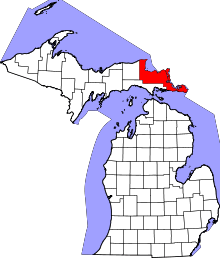 | |
| Village | ||
| Charter township | ||
| General law townships | ||
| Unincorporated communities | ||
| Indian reservations | ||
| Ghost towns | ||
| Authority control |
|---|