Tobin Lake
| Tobin Lake | |
|---|---|
 NASA image of Tobin Lake | |
| Location | Saskatchewan |
| Coordinates | 53°35′N 103°30′W / 53.583°N 103.500°WCoordinates: 53°35′N 103°30′W / 53.583°N 103.500°W |
| Type | reservoir |
| Primary inflows | Saskatchewan River |
| Primary outflows | Saskatchewan River |
| Basin countries | Canada |
| Islands | none |
| Settlements | none |
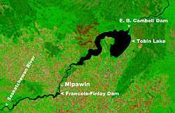
Tobin Lake is a reservoir of Saskatchewan, Canada. Tobin Lake was formed by the E.B. Campbell Dam on the Saskatchewan River in 1963. The dam was originally named Squaw Rapids Dam, but was then renamed E.B. Campbell Dam in 1988 as local first nations people considered the name squaw racist. It is near to the town of Nipawin and is downstream from Codette Lake, formed by Francois Finlay Dam in 1986. The construction of Francois Finlay Dam earned Nipawin the nickname The Town of Two Lakes.
The lake is accessed on the north side by Highway 35, on the east side by Highway 123 and on the southwest side by Highway 255.[1][2]
Fish species
Tobin Lake is home to several species of fish including walleye, sauger, yellow perch, lake sturgeon, northern pike, goldeye, mooneye, lake whitefish, burbot, white sucker, longnose sucker and shorthead redhorse.
Father Mariuz Zajac, from Carrot River caught the world ice fishing record for walleye here in 2005 at 9.8 kg (18.30 lbs). The lake is debatably the top walleye fishing lake in Saskatchewan.
Gallery
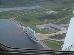 Francois Finlay dam and Nipawin Hydroelectric Generating Station |
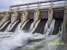 E.B. Campbell Dam Spillway |
See also
References
- ↑ "Natural Resources Canada-Canadian Geographical Names (Tobin Lake)". Retrieved 2014-08-29.
- ↑ "Atlas of Canada Toporama". Retrieved 2014-08-29.
External links