Tiptop, Virginia
| Tiptop, Virginia | |
|---|---|
| Unincorporated community | |
 Tiptop, Virginia  Tiptop, Virginia | |
| Coordinates: 37°12′39″N 81°26′02″W / 37.21083°N 81.43389°WCoordinates: 37°12′39″N 81°26′02″W / 37.21083°N 81.43389°W | |
| Country | United States |
| State | Virginia |
| County | Tazewell |
| Elevation | 2,756 ft (840 m) |
| Time zone | UTC−5 (Eastern (EST)) |
| • Summer (DST) | UTC−4 (EDT) |
| Area code(s) | 276 |
| GNIS feature ID | 1487929[1] |
Tiptop is an unincorporated community located in Tazewell County, Virginia, United States. Tip Top was named for being the highest elevated point on the Norfolk and Western Railroad.
References
Municipalities and communities of Tazewell County, Virginia, United States | ||
|---|---|---|
| Towns | 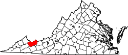 | |
| CDPs | ||
| Unincorporated communities | ||
| Footnotes | ‡This populated place also has portions in an adjacent county or counties | |
This article is issued from
Wikipedia.
The text is licensed under Creative Commons - Attribution - Sharealike.
Additional terms may apply for the media files.