Red Ash, Virginia
| Red Ash, Virginia | |
|---|---|
| Unincorporated community | |
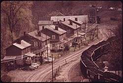 Red Ash in 1974 | |
 Red Ash, Virginia  Red Ash, Virginia | |
| Coordinates: 37°6′48″N 81°52′15″W / 37.11333°N 81.87083°WCoordinates: 37°6′48″N 81°52′15″W / 37.11333°N 81.87083°W | |
| Country | United States |
| State | Virginia |
| County | Tazewell |
| Elevation | 2,155 ft (657 m) |
| Time zone | UTC-5 (Eastern (EST)) |
| • Summer (DST) | UTC-4 (EDT) |
| ZIP codes | 24640 |
| GNIS feature ID | 1499940[1] |
Red Ash is an unincorporated community and coal town located in Tazewell County, Virginia, United States. The community is located along VSR 804, which runs parallel to US 460 north of Raven, Virginia.
References
Municipalities and communities of Tazewell County, Virginia, United States | ||
|---|---|---|
| Towns |  | |
| CDPs | ||
| Unincorporated communities | ||
| Footnotes | ‡This populated place also has portions in an adjacent county or counties | |
This article is issued from
Wikipedia.
The text is licensed under Creative Commons - Attribution - Sharealike.
Additional terms may apply for the media files.