Tighes Hill, New South Wales
| Tighes Hill Newcastle, New South Wales | |||||||||||||||
|---|---|---|---|---|---|---|---|---|---|---|---|---|---|---|---|
| Population | 1,680 (2016 census)[1] | ||||||||||||||
| • Density | 2,400/km2 (6,200/sq mi) | ||||||||||||||
| Established | 1870s | ||||||||||||||
| Postcode(s) | 2297 | ||||||||||||||
| Area | 0.7 km2 (0.3 sq mi) | ||||||||||||||
| Location | 5 km (3 mi) NW of Newcastle | ||||||||||||||
| LGA(s) | City of Newcastle | ||||||||||||||
| Parish | Newcastle | ||||||||||||||
| State electorate(s) | Newcastle | ||||||||||||||
| Federal Division(s) | Newcastle | ||||||||||||||
| |||||||||||||||
Tighes Hill /ˈtaɪz/ is a north-western suburb of Newcastle, New South Wales and was named after A.A.P. Tighe, an early resident, who in 1843 bought the estate.[2] It is primarily an industrial area with residential parts expanding toward Mayfield. A video tribute has been filmed of this grand old suburb, featuring the Catholic Church.
Origins
Tighes Hill developed from the construction of a bridge over Throsby Creek at the opening of the Ferndale Colliery in 1877. Within three years the suburb had a school, post office, church and stores. In April 1894, a tram line was opened to Tighes Hill which extended to Mayfield in 1901.[3]
Today
Tighes Hill provides housing near the CBD.[3] Tighes Hill has now become a trendy inner suburb of the Newcastle inner city area with a large influx of young professionals and families looking to live an inner city lifestyle at the affordable end of town. In August 2010, a property in Tighes Terrace,Tighes Hill was sold at a record breaking price of $950,000 for this inner city suburb. The School of Arts building has had a variety of uses supporting arts and the community in Newcastle. Recently the building reopened as The Tighes Hill School of Arts, Gallery in January 2009. The Newcastle Campus of Hunter Institute of TAFE is located here.
Gallery
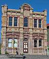 Tighes Hill School of Arts, built in 1900
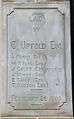 Plaque commemorating the laying of a foundation stone by Charles Upfold in 1900, for the School of Arts building
References
- ↑ Australian Bureau of Statistics (27 June 2017). "Tighes Hill (State Suburb)". 2016 Census QuickStats. Retrieved 9 February 2018.

- ↑ Hunter Valley Place Names and their Meanings
- 1 2 Newcastle City Council, Discover our Suburbs
- "Tighes Hill". Land and Property Management Authority - Spatial Information eXchange. New South Wales Land and Property Information. Retrieved 14 May 2008.